Auquainville | |
|---|---|
Part of
Livarot-Pays-d'Auge | |
.JPG) The centre of Auquainville | |
 Auquainville  Auquainville | |
| Coordinates: 49°03′27″N 0°14′24″E / 49.0575°N 0.24°E | |
| Country | France |
| Region | Normandy |
| Department | Calvados |
| Arrondissement | Lisieux |
| Canton | Livarot-Pays-d'Auge |
| Commune | Livarot-Pays-d'Auge |
| Area 1 | 9.56 km2 (3.69 sq mi) |
| Population (2019)
[1] | 293 |
| • Density | 31/km2 (79/sq mi) |
| Time zone | UTC+01:00 ( CET) |
| • Summer ( DST) | UTC+02:00 ( CEST) |
| Postal code | 14140 |
| Elevation | 67–184 m (220–604 ft) (avg. 250 m or 820 ft) |
| 1 French Land Register data, which excludes lakes, ponds, glaciers > 1 km2 (0.386 sq mi or 247 acres) and river estuaries. | |
Auquainville (French pronunciation: [okɛ̃vil] ) is a former commune in the Calvados department in the Normandy region of north-western France. On 1 January 2016, it was merged into the new commune of Livarot-Pays-d'Auge. [2]
Auquainville is located some 10 km south of Lisieux and 13 km west by north-west of Orbec. Access to the commune is by the D149 road which comes from Saint-Martin-de-Mailloc in the north-east and passes south through the commune and the village continuing to Livarot in the south-west. The D64 road comes from Saint-Martin-de-la-Lieue in the north and passes south through the east of the commune to Fervaques. The D135B branches east off the D64 in the commune and joins the D135 just east of the commune. Apart from the village, there are the hamlets of La Blondeliere in the west with Le Mollants and Le Maubuisson in the east. The commune is mixed forest and farmland with a particularly large forest to the west of the village (the Bois des Grandes Ventes). [3]
The Touques river passes through the commune from south to north just east of the village and continues north to join the ocean at Trouville-sur-Mer. The Ruisseau de la Marette rises in the commune and flows east into the Touques. [3]
Neighbouring communes and villages
[3] | |
|---|---|
In 1831, Auquainville (456 inhabitants) merged with Saint-Aubin-sur-Aquainville (91 inhabitants). Saint-Aubin-sur-Auquainville was south of Auquainville.
.JPG)
List of Successive Mayors [4]
| From | To | Name | Party | Position |
|---|---|---|---|---|
| 1983 | 2014 | Raymond Géret | Farmer | |
| 2014 | 2016 | Philippe Soetaert |
.JPG)
The inhabitants of the commune are known as Auquainvillais or Auquainvillaises in French. [5]
|
| |||||||||||||||||||||||||||||||||||||||||||||||||||||||||||||||||||||||||||||||||||||||||||||||||||||||||||||||
| ||||||||||||||||||||||||||||||||||||||||||||||||||||||||||||||||||||||||||||||||||||||||||||||||||||||||||||||||
| Source: EHESS [6] and INSEE [7] | ||||||||||||||||||||||||||||||||||||||||||||||||||||||||||||||||||||||||||||||||||||||||||||||||||||||||||||||||
.JPG)
The commune has a number of buildings and structures that are registered as historical monuments:
- Lortier Manor (17th century)
 [8]
[8] - Caudemone Manor (15th century)
[9]
- A Mill for
Fuller's Earth (19th century)
[10]
.jpg)
.JPG)
The commune has several religious buildings and structures that are registered as historical monuments:
- The Church of Saint Aubin (15th century).
[11] The church was decommissioned when Saint-Aubin-sur-Auquainville was incorporated into the commune of Auquainville in 1831 and was then used as a burial chapel by the Custine family. The choir with a flat apse indicates the building is from the late Middle Ages. It has a single nave and tower sitting on the western gable. The windows and door have without doubt been re-engineered in the 18th century. Inside, the building has retained all of its former layout. The Church contains many items that are registered as historical objects:
- The Church of Notre-Dame (15th century).
[14] The Church contains many items that are registered as historical objects:
- A
Retable (17th century)
 [15]
[15] - A Group Sculpture: Education of the Virgin (17th century)
[16]
- A Retable (17th century)
[17]
- A Painting: The Annunciation (17th century)
[18]
- A Retable (17th century)
[19]
- A
Tabernacle (17th century)
[20]
- A fragment of
Stained glass (16th century)
[21]
- A Painting: The placing in the tomb (17th century)
[22]
- A Painting: The martyrdom of Saint Ursula (17th century)
[23]
- An Altar (17th century)
[24]
- An Altar (17th century)
[25]
- The Altar facing (17th century)
[26]
- The Altar wood carving of the Annunciation (17th century)
[27]
- A
Retable (17th century)
- The Church of Saint Pierre has a number of items that are registered as historical objects:
-
 Church of Notre Dame
 -
 Church of Notre Dame: the Nave
 -
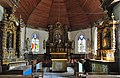 Church of Notre Dame: the Altar
 -
 Church of Notre Dame: Altar detail
 -
 Church of Notre Dame: Altar detail
.JPG)
.JPG)
.jpg)
.JPG)
.jpg)
- Astolphe Louis Léonor, Marquis de Custine (1790-1857), writer, is buried in the Chapel of Saint-Aubin-sur-Auquainville.
- Auquaniville on the 1750 Cassini Map (N.B. Misspelt on the map)
- ^ Téléchargement du fichier d'ensemble des populations légales en 2019, INSEE
- ^ Arrêté préfectoral 24 December 2015 (in French)
- ^ a b c Google Maps
- ^ List of Mayors of France (in French)
- ^ Le nom des habitants du 14 - Calvados, habitants.fr
- ^ Des villages de Cassini aux communes d'aujourd'hui: Commune data sheet Auquainville, EHESS (in French).
- ^ Populations légales 2012, INSEE
- ^ Ministry of Culture, Mérimée PA00111022 Lortier Manor (in French)
-
^ Ministry of Culture, Mérimée
PA00111021 Caudemone Manor (in French)

-
^ Ministry of Culture, Mérimée
IA14000757 Mill for Fullers Earth (in French)
- ^ Ministry of Culture, Mérimée PA14000075 Church of Saint Aubin (in French)
-
^ Ministry of Culture, Palissy
PM14001194 Main Altar, seating, Tabernacle urn, Retable, an Altar Painting: the Agony of Christ in the garden of olives, and 2 Statues of St. Aubin and St. Sebastian (in French)
-
^ Ministry of Culture, Palissy
PM14001195 Secondary Altar, seating, Retables, and 2 Statues of the Virgin and St. Quentin (in French)
-
^ Ministry of Culture, Mérimée
PA00111020 Church (in French)
- ^ Ministry of Culture, Palissy PM14000957 Retable (in French)
- ^ Ministry of Culture, Palissy PM14000956 Group Sculpture: Education of the Virgin (in French)
- ^ Ministry of Culture, Palissy PM14000955 Retable (in French)
- ^ Ministry of Culture, Palissy PM14000954 Painting: The Annunciation (in French)
- ^ Ministry of Culture, Palissy PM14000953 Retable (in French)
- ^ Ministry of Culture, Palissy PM14000952 Tabernacle (in French)
- ^ Ministry of Culture, Palissy PM14000022 Fragment of Stained glass (in French)
- ^ Ministry of Culture, Palissy PM14000021 Painting: The placing in the tomb (in French)
- ^ Ministry of Culture, Palissy PM14000020 Painting: The martyrdom of Saint Ursula (in French)
-
^ Ministry of Culture, Palissy
PM14000019 Altar (in French)
-
^ Ministry of Culture, Palissy
PM14000018 Altar (in French)
-
^ Ministry of Culture, Palissy
PM14000017 Altar facing (in French)
-
^ Ministry of Culture, Palissy
PM14000016 Altar wood carving of the Annunciation (in French)
-
^ Ministry of Culture, Palissy
IM14005204 Stained glass window with a lady's head (in French)
- ^ Ministry of Culture, Palissy IM14005203 Decorative stained glass (in French)
-
^ Ministry of Culture, Palissy
IM14005202 2 Stained glass windows: St. John and St. Mark and St. Matthew and St. Luke (in French)
| Authority control databases: National |
|---|
Auquainville | |
|---|---|
Part of
Livarot-Pays-d'Auge | |
|
The centre of Auquainville | |
Auquainville Auquainville | |
| Coordinates: 49°03′27″N 0°14′24″E / 49.0575°N 0.24°E | |
| Country | France |
| Region | Normandy |
| Department | Calvados |
| Arrondissement | Lisieux |
| Canton | Livarot-Pays-d'Auge |
| Commune | Livarot-Pays-d'Auge |
| Area 1 | 9.56 km2 (3.69 sq mi) |
| Population (2019)
[1] | 293 |
| • Density | 31/km2 (79/sq mi) |
| Time zone | UTC+01:00 ( CET) |
| • Summer ( DST) | UTC+02:00 ( CEST) |
| Postal code | 14140 |
| Elevation | 67–184 m (220–604 ft) (avg. 250 m or 820 ft) |
| 1 French Land Register data, which excludes lakes, ponds, glaciers > 1 km2 (0.386 sq mi or 247 acres) and river estuaries. | |
Auquainville (French pronunciation: [okɛ̃vil] ) is a former commune in the Calvados department in the Normandy region of north-western France. On 1 January 2016, it was merged into the new commune of Livarot-Pays-d'Auge. [2]
Auquainville is located some 10 km south of Lisieux and 13 km west by north-west of Orbec. Access to the commune is by the D149 road which comes from Saint-Martin-de-Mailloc in the north-east and passes south through the commune and the village continuing to Livarot in the south-west. The D64 road comes from Saint-Martin-de-la-Lieue in the north and passes south through the east of the commune to Fervaques. The D135B branches east off the D64 in the commune and joins the D135 just east of the commune. Apart from the village, there are the hamlets of La Blondeliere in the west with Le Mollants and Le Maubuisson in the east. The commune is mixed forest and farmland with a particularly large forest to the west of the village (the Bois des Grandes Ventes). [3]
The Touques river passes through the commune from south to north just east of the village and continues north to join the ocean at Trouville-sur-Mer. The Ruisseau de la Marette rises in the commune and flows east into the Touques. [3]
Neighbouring communes and villages
[3] | |
|---|---|
In 1831, Auquainville (456 inhabitants) merged with Saint-Aubin-sur-Aquainville (91 inhabitants). Saint-Aubin-sur-Auquainville was south of Auquainville.
List of Successive Mayors [4]
| From | To | Name | Party | Position |
|---|---|---|---|---|
| 1983 | 2014 | Raymond Géret | Farmer | |
| 2014 | 2016 | Philippe Soetaert |
The inhabitants of the commune are known as Auquainvillais or Auquainvillaises in French. [5]
|
| |||||||||||||||||||||||||||||||||||||||||||||||||||||||||||||||||||||||||||||||||||||||||||||||||||||||||||||||
| ||||||||||||||||||||||||||||||||||||||||||||||||||||||||||||||||||||||||||||||||||||||||||||||||||||||||||||||||
| Source: EHESS [6] and INSEE [7] | ||||||||||||||||||||||||||||||||||||||||||||||||||||||||||||||||||||||||||||||||||||||||||||||||||||||||||||||||
The commune has a number of buildings and structures that are registered as historical monuments:
- Lortier Manor (17th century)
[8]
- Caudemone Manor (15th century)
[9]
- A Mill for
Fuller's Earth (19th century)
[10]
The commune has several religious buildings and structures that are registered as historical monuments:
- The Church of Saint Aubin (15th century).
[11] The church was decommissioned when Saint-Aubin-sur-Auquainville was incorporated into the commune of Auquainville in 1831 and was then used as a burial chapel by the Custine family. The choir with a flat apse indicates the building is from the late Middle Ages. It has a single nave and tower sitting on the western gable. The windows and door have without doubt been re-engineered in the 18th century. Inside, the building has retained all of its former layout. The Church contains many items that are registered as historical objects:
- The Church of Notre-Dame (15th century).
[14] The Church contains many items that are registered as historical objects:
- A
Retable (17th century)
[15]
- A Group Sculpture: Education of the Virgin (17th century)
[16]
- A Retable (17th century)
[17]
- A Painting: The Annunciation (17th century)
[18]
- A Retable (17th century)
[19]
- A
Tabernacle (17th century)
[20]
- A fragment of
Stained glass (16th century)
[21]
- A Painting: The placing in the tomb (17th century)
[22]
- A Painting: The martyrdom of Saint Ursula (17th century)
[23]
- An Altar (17th century)
[24]
- An Altar (17th century)
[25]
- The Altar facing (17th century)
[26]
- The Altar wood carving of the Annunciation (17th century)
[27]
- A
Retable (17th century)
- The Church of Saint Pierre has a number of items that are registered as historical objects:
-
Church of Notre Dame
-
Church of Notre Dame: the Nave
-
Church of Notre Dame: the Altar
-
Church of Notre Dame: Altar detail
-
Church of Notre Dame: Altar detail
- Astolphe Louis Léonor, Marquis de Custine (1790-1857), writer, is buried in the Chapel of Saint-Aubin-sur-Auquainville.
- Auquaniville on the 1750 Cassini Map (N.B. Misspelt on the map)
- ^ Téléchargement du fichier d'ensemble des populations légales en 2019, INSEE
- ^ Arrêté préfectoral 24 December 2015 (in French)
- ^ a b c Google Maps
- ^ List of Mayors of France (in French)
- ^ Le nom des habitants du 14 - Calvados, habitants.fr
- ^ Des villages de Cassini aux communes d'aujourd'hui: Commune data sheet Auquainville, EHESS (in French).
- ^ Populations légales 2012, INSEE
- ^ Ministry of Culture, Mérimée PA00111022 Lortier Manor (in French)
-
^ Ministry of Culture, Mérimée
PA00111021 Caudemone Manor (in French)
-
^ Ministry of Culture, Mérimée
IA14000757 Mill for Fullers Earth (in French)
- ^ Ministry of Culture, Mérimée PA14000075 Church of Saint Aubin (in French)
-
^ Ministry of Culture, Palissy
PM14001194 Main Altar, seating, Tabernacle urn, Retable, an Altar Painting: the Agony of Christ in the garden of olives, and 2 Statues of St. Aubin and St. Sebastian (in French)
-
^ Ministry of Culture, Palissy
PM14001195 Secondary Altar, seating, Retables, and 2 Statues of the Virgin and St. Quentin (in French)
-
^ Ministry of Culture, Mérimée
PA00111020 Church (in French)
- ^ Ministry of Culture, Palissy PM14000957 Retable (in French)
- ^ Ministry of Culture, Palissy PM14000956 Group Sculpture: Education of the Virgin (in French)
- ^ Ministry of Culture, Palissy PM14000955 Retable (in French)
- ^ Ministry of Culture, Palissy PM14000954 Painting: The Annunciation (in French)
- ^ Ministry of Culture, Palissy PM14000953 Retable (in French)
- ^ Ministry of Culture, Palissy PM14000952 Tabernacle (in French)
- ^ Ministry of Culture, Palissy PM14000022 Fragment of Stained glass (in French)
- ^ Ministry of Culture, Palissy PM14000021 Painting: The placing in the tomb (in French)
- ^ Ministry of Culture, Palissy PM14000020 Painting: The martyrdom of Saint Ursula (in French)
-
^ Ministry of Culture, Palissy
PM14000019 Altar (in French)
-
^ Ministry of Culture, Palissy
PM14000018 Altar (in French)
-
^ Ministry of Culture, Palissy
PM14000017 Altar facing (in French)
-
^ Ministry of Culture, Palissy
PM14000016 Altar wood carving of the Annunciation (in French)
-
^ Ministry of Culture, Palissy
IM14005204 Stained glass window with a lady's head (in French)
- ^ Ministry of Culture, Palissy IM14005203 Decorative stained glass (in French)
-
^ Ministry of Culture, Palissy
IM14005202 2 Stained glass windows: St. John and St. Mark and St. Matthew and St. Luke (in French)
| Authority control databases: National |
|---|