Arvigna | |
|---|---|
 Town hall | |
 Coat of arms | |
 Arvigna  Arvigna | |
| Coordinates: 43°03′49″N 1°43′59″E / 43.0636°N 1.7331°E | |
| Country | France |
| Region | Occitania |
| Department | Ariège |
| Arrondissement | Pamiers |
| Canton | Pamiers-2 |
| Intercommunality | CC Portes Ariège Pyrénées |
| Government | |
| • Mayor (2020–2026) | Maxime Roubichou [1] |
| Area 1 | 8.6 km2 (3.3 sq mi) |
| Population (2021)
[2] | 230 |
| • Density | 27/km2 (69/sq mi) |
| Time zone | UTC+01:00 ( CET) |
| • Summer ( DST) | UTC+02:00 ( CEST) |
| INSEE/Postal code |
09022 /09100 |
| Elevation | 279–490 m (915–1,608 ft) (avg. 650 m or 2,130 ft) |
| 1 French Land Register data, which excludes lakes, ponds, glaciers > 1 km2 (0.386 sq mi or 247 acres) and river estuaries. | |
Arvigna (French pronunciation: [aʁvinɑ̃]; Occitan: Arvinhan) is a commune in the Ariège department in the Occitanie region of southwestern France.
Arvigna is a commune in the Pre-Pyrenees located some 11 km south-east of Pamiers and 12 km west by south-west of Mirepoix. Access to the commune is by the D12 road from Vira in the south-west passing through the commune east of the village and continuing to join the D119 north of the commune. There are extensive forests in the commune covering about 40% of the land area with the rest farmland. [3]
The Douctouyre river flows along the edge of the forests in the north-east of the commune from south-east to north and it continues north to join the Hers near Vals. Four streams rise in the commune and flow north-east to join the Douctouyre in the commune - the Ruisseau de Lafage, the Ruisseau de Truffet, an unnamed stream, and the Ruisseau de Minguet. The western border is delineated by an unnamed stream which flows north to join Le Canal south of Saint-Amadou. [3]
The population is mostly split between four hamlets (Languit, Menet, Roubichou, les Bordes) which are scattered around the Town hall and the school. The church is on the slopes of Cantegril hill above Arvigna village. There are eight other hamlets in the commune: [4]
- Le Castel
- Marty
- Minguet
- Monge
- Peres
- Le Pioy
- La Rose
- Le Soula
- En Terraine
Places adjacent to Arvigna | ||||||||||||||||
|---|---|---|---|---|---|---|---|---|---|---|---|---|---|---|---|---|
| ||||||||||||||||
|
Blazon: Or, 3 chevrons of Sable debruised by a castle Gules towered at centre turreted port open, windowed and masoned in Sable, bordure in Vert.
|
List of Successive Mayors [5]
| From | To | Name | Party | Position |
|---|---|---|---|---|
| 1965 | 1977 | Georges Chaubet | SE | |
| 1977 | 1987 | Pierre Naudi | SE | Farmer |
| 1987 | 1995 | André Jalibert | SE | Farmer |
| 1995 | 2008 | Jacques Mirouse | PS | Retired |
| 2008 | 2020 | Jean-François Naudi | SE | Farmer |
| 2020 | 2026 | Maxime Roubichou |
The inhabitants of the commune are known as Arvignais or Arvignaises in French. [6]
|
| ||||||||||||||||||||||||||||||||||||||||||||||||||||||||||||||||||||||||||||||||||||||||||||||||||||||||||||||||||
| Source: EHESS [7] and INSEE [8] | |||||||||||||||||||||||||||||||||||||||||||||||||||||||||||||||||||||||||||||||||||||||||||||||||||||||||||||||||||
There are four structures registered as historical monuments in Arvigna. These are:
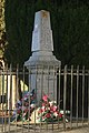
- War memorial (20th century).
 [9] This memorial is located inside the walls of the church.
 - Funeral Chapel of the Barrière family (19th century)
[10]
- Wayside Cross at Roubichou (1813)
 [11]
[11] - Parish Church of Saint-Vincent and Saint-Martial (14th century).
[12]
The Church of Saint-Vincent and Saint-Martial contains many items that have been registered as historical objects. These are:
- Funeral Cross of Father Louis Richard (20th century)
[13]
- Cemetery Cross (19th century)
[14]
- The surroundings of the war memorial including the large statues of Saint Joan of Arc and Saint Germaine of Pibrac with their
Corbels (20th century)
[15]
- 2
Altar Towers (19th century)
[16]
- Cape and Cloth of Gold (19th century)
[17]
- 4 sides of the processional
dais (19th century)
[18]
- Exhibition veil of the sacremental saint: IHS (19th century)
[19]
- Processional banner: Baby Jesus blessing the world (19th century)
[20]
- Baptismal fonts and a sculpture of the baptism of Christ (19th century)
[21]
- Secondary Altar of the Virgin, Altar tombstone, Altar seating, Tabernacle, and small statue: Virgin of the Sacred Heart (19th century)
[22]
-
Harmonium (19th-20th century)
[23]
- Main Altar, Altar tombstone, Altar seating, and Tabernacle (19th century)
[24]
- Collection plate (17th century)
[25]
-
Stoup: 3 anthropomorphic heads (17th century)
[26]
- Stoup (on a footing) (17th century)
[27]
- Family pew (19th century)
[28]
- Sacristy furniture (17th century)
[29]
- 4 Funeral candlesticks (19th century)
[30]
- Altar Cross: Christ on the cross (17th century)
[31]
-
Chalice with its
Paten (20th century)
[32]
- Solar
Monstrance (19th century)
[33]
- Mortuary cloth: with deaths-heads insignia (19th century)
[34]
- Mortuary cloth (19th century)
[35]
- Aube (19th century)
[36]
- Paddle: IHS (19th century)
[37]
- Paddle: IHS (18th century)
[38]
- Statuette: Virgin and child (18th century)
[39]
- Pair of paintings: Saint Vincent and Saint Martial (19th century)
[40]
- Altar table with its frame: Calvary St. Peter and St. Martial (17th century)
[41]
- 4 Stained glass windows (19th century)
[42]
- The Church furniture
[43]
- 4 paintings on the processional dais (19th century)
[44]
-
 War memorial
 -
 The Church of Arvigna painted by R. Labitrie (1983)
 -
 The fortified Church
 -
 The Bell tower of the church


School: an inter-communal educational grouping (RPI) for the Douctouyre Valley groups together the communes of Arvigna, Calzan, Vira, [Dun], Lieurac, and Carla-de-Roquefort. Five classes are open, including one at Arvigna with a canteen service and a CLAE. There is a leisure centre that operates on Wednesdays and during the holidays at Dun.
There are two rural Gîtes (apartments), a Hiking or Mountain bike trail 7 km long trail which is an Earth Society (maquisards and guerrillas) path starting from the hamlet of Minguet to the site of a former Cathar castle (not restored).

- The Festival Committee organises various annual events, local festivals and fireworks. It includes many people from the commune and elsewhere, young and old.
- Hunting Association
- Walking group: Les Caminaïres
- ^ "Répertoire national des élus: les maires". data.gouv.fr, Plateforme ouverte des données publiques françaises (in French). 2 December 2020.
- ^ "Populations légales 2021" (in French). The National Institute of Statistics and Economic Studies. 28 December 2023.
- ^ a b c Google Maps
- ^ Géoportail, IGN (in French)
- ^ List of Mayors of France (in French)
- ^ Le nom des habitants du 09 - Ariège, habitants.fr
- ^ Des villages de Cassini aux communes d'aujourd'hui: Commune data sheet Arvigna, EHESS (in French).
- ^ Population en historique depuis 1968, INSEE
- ^ Ministry of Culture, Mérimée IA09000072 War memorial (in French)
- ^ Ministry of Culture, Mérimée IA09000186 Funeral Chapel of the Barrière family (in French)
- ^ Ministry of Culture, Palissy IM09001045 Wayside cross at Roubichou (in French)
- ^ Ministry of Culture, Mérimée IA09000052 Church of Saint-Vincent and Saint-Martial (in French)
- ^ Ministry of Culture, Palissy IM09000940 Funeral Cross of Father Louis Richard (in French)
- ^ Ministry of Culture, Palissy IM09000853 Cemetery Cross (in French)
- ^ Ministry of Culture, Palissy IM09000922 Surroundings of the war memorial (in French)
- ^ Ministry of Culture, Palissy IM09000852 2 Altar Towers (in French)
- ^ Ministry of Culture, Palissy IM09000779 Cape and Cloth of Gold (in French)
- ^ Ministry of Culture, Palissy IM09000778 4 sides of the processional dais (in French)
- ^ Ministry of Culture, Palissy IM09000777 Exhibition veil of the sacremental saint (in French)
- ^ Ministry of Culture, Palissy IM09000776 Processional banner: Baby Jesus blessing the world (in French)
- ^ Ministry of Culture, Palissy IM09000775 Baptismal fonts and a sculpture of the baptism of Christ (in French)
- ^ Ministry of Culture, Palissy IM09000774 Secondary Altar of the Virgin, Altar tombstone, Altar seating, Tabernacle, and small statue: Virgin of the Sacred Heart (in French)
- ^ Ministry of Culture, Palissy IM09000773 Harmonium (in French)
- ^ Ministry of Culture, Palissy IM09000772 Main Altar, Altar tombstone, Altar seating, and Tabernacle (in French)
- ^ Ministry of Culture, Palissy IM09000771 Collection plate (in French)
- ^ Ministry of Culture, Palissy IM09000770 Stoup: 3 anthropomorphic heads (in French)
- ^ Ministry of Culture, Palissy IM09000769 Stoup (on a footing) (in French)
- ^ Ministry of Culture, Palissy IM09000768 Family pew (in French)
- ^ Ministry of Culture, Palissy IM09000767 Sacristy furniture (in French)
- ^ Ministry of Culture, Palissy IM09000766 4 Funeral Candlesticks (in French)
- ^ Ministry of Culture, Palissy IM09000765 Altar Cross: Christ on the cross (in French)
- ^ Ministry of Culture, Palissy IM09000764 Chalice with its Paten (in French)
- ^ Ministry of Culture, Palissy IM09000763 Solar Monstrance (in French)
- ^ Ministry of Culture, Palissy IM09000762 Mortuary cloth: with deaths-heads insignia (in French)
- ^ Ministry of Culture, Palissy IM09000761 Mortuary cloth (in French)
- ^ Ministry of Culture, Palissy IM09000760 Aube (in French)
- ^ Ministry of Culture, Palissy IM09000759 Paddle: IHS (in French)
- ^ Ministry of Culture, Palissy IM09000758 Paddle: IHS (in French)
- ^ Ministry of Culture, Palissy IM09000757 Statuette: Virgin and child (in French)
- ^ Ministry of Culture, Palissy IM09000756 Pair of paintings: Saint Vincent and Saint Martial (in French)
- ^ Ministry of Culture, Palissy IM09000755 Altar table with its frame: Calvary St. Peter and St. Martial (in French)
- ^ Ministry of Culture, Palissy IM09000754 4 Stained glass windows (in French)
- ^ Ministry of Culture, Palissy IM09000753 Church furniture (in French)
- ^ Ministry of Culture, Palissy IM09000875 4 paintings on the processional dais (in French)
- Arvigna on the old National Geographic Institute website (in French)
- Arvigna on Géoportail, National Geographic Institute (IGN) website (in French)
- Arvigna on the 1750 Cassini Map
Arvigna | |
|---|---|
|
Town hall | |
|
Coat of arms | |
Arvigna Arvigna | |
| Coordinates: 43°03′49″N 1°43′59″E / 43.0636°N 1.7331°E | |
| Country | France |
| Region | Occitania |
| Department | Ariège |
| Arrondissement | Pamiers |
| Canton | Pamiers-2 |
| Intercommunality | CC Portes Ariège Pyrénées |
| Government | |
| • Mayor (2020–2026) | Maxime Roubichou [1] |
| Area 1 | 8.6 km2 (3.3 sq mi) |
| Population (2021)
[2] | 230 |
| • Density | 27/km2 (69/sq mi) |
| Time zone | UTC+01:00 ( CET) |
| • Summer ( DST) | UTC+02:00 ( CEST) |
| INSEE/Postal code |
09022 /09100 |
| Elevation | 279–490 m (915–1,608 ft) (avg. 650 m or 2,130 ft) |
| 1 French Land Register data, which excludes lakes, ponds, glaciers > 1 km2 (0.386 sq mi or 247 acres) and river estuaries. | |
Arvigna (French pronunciation: [aʁvinɑ̃]; Occitan: Arvinhan) is a commune in the Ariège department in the Occitanie region of southwestern France.
Arvigna is a commune in the Pre-Pyrenees located some 11 km south-east of Pamiers and 12 km west by south-west of Mirepoix. Access to the commune is by the D12 road from Vira in the south-west passing through the commune east of the village and continuing to join the D119 north of the commune. There are extensive forests in the commune covering about 40% of the land area with the rest farmland. [3]
The Douctouyre river flows along the edge of the forests in the north-east of the commune from south-east to north and it continues north to join the Hers near Vals. Four streams rise in the commune and flow north-east to join the Douctouyre in the commune - the Ruisseau de Lafage, the Ruisseau de Truffet, an unnamed stream, and the Ruisseau de Minguet. The western border is delineated by an unnamed stream which flows north to join Le Canal south of Saint-Amadou. [3]
The population is mostly split between four hamlets (Languit, Menet, Roubichou, les Bordes) which are scattered around the Town hall and the school. The church is on the slopes of Cantegril hill above Arvigna village. There are eight other hamlets in the commune: [4]
- Le Castel
- Marty
- Minguet
- Monge
- Peres
- Le Pioy
- La Rose
- Le Soula
- En Terraine
Places adjacent to Arvigna | ||||||||||||||||
|---|---|---|---|---|---|---|---|---|---|---|---|---|---|---|---|---|
| ||||||||||||||||
|
Blazon: Or, 3 chevrons of Sable debruised by a castle Gules towered at centre turreted port open, windowed and masoned in Sable, bordure in Vert.
|
List of Successive Mayors [5]
| From | To | Name | Party | Position |
|---|---|---|---|---|
| 1965 | 1977 | Georges Chaubet | SE | |
| 1977 | 1987 | Pierre Naudi | SE | Farmer |
| 1987 | 1995 | André Jalibert | SE | Farmer |
| 1995 | 2008 | Jacques Mirouse | PS | Retired |
| 2008 | 2020 | Jean-François Naudi | SE | Farmer |
| 2020 | 2026 | Maxime Roubichou |
The inhabitants of the commune are known as Arvignais or Arvignaises in French. [6]
|
| ||||||||||||||||||||||||||||||||||||||||||||||||||||||||||||||||||||||||||||||||||||||||||||||||||||||||||||||||||
| Source: EHESS [7] and INSEE [8] | |||||||||||||||||||||||||||||||||||||||||||||||||||||||||||||||||||||||||||||||||||||||||||||||||||||||||||||||||||
There are four structures registered as historical monuments in Arvigna. These are:
- War memorial (20th century).
[9] This memorial is located inside the walls of the church.
- Funeral Chapel of the Barrière family (19th century)
[10]
- Wayside Cross at Roubichou (1813)
[11]
- Parish Church of Saint-Vincent and Saint-Martial (14th century).
[12]
The Church of Saint-Vincent and Saint-Martial contains many items that have been registered as historical objects. These are:
- Funeral Cross of Father Louis Richard (20th century)
[13]
- Cemetery Cross (19th century)
[14]
- The surroundings of the war memorial including the large statues of Saint Joan of Arc and Saint Germaine of Pibrac with their
Corbels (20th century)
[15]
- 2
Altar Towers (19th century)
[16]
- Cape and Cloth of Gold (19th century)
[17]
- 4 sides of the processional
dais (19th century)
[18]
- Exhibition veil of the sacremental saint: IHS (19th century)
[19]
- Processional banner: Baby Jesus blessing the world (19th century)
[20]
- Baptismal fonts and a sculpture of the baptism of Christ (19th century)
[21]
- Secondary Altar of the Virgin, Altar tombstone, Altar seating, Tabernacle, and small statue: Virgin of the Sacred Heart (19th century)
[22]
-
Harmonium (19th-20th century)
[23]
- Main Altar, Altar tombstone, Altar seating, and Tabernacle (19th century)
[24]
- Collection plate (17th century)
[25]
-
Stoup: 3 anthropomorphic heads (17th century)
[26]
- Stoup (on a footing) (17th century)
[27]
- Family pew (19th century)
[28]
- Sacristy furniture (17th century)
[29]
- 4 Funeral candlesticks (19th century)
[30]
- Altar Cross: Christ on the cross (17th century)
[31]
-
Chalice with its
Paten (20th century)
[32]
- Solar
Monstrance (19th century)
[33]
- Mortuary cloth: with deaths-heads insignia (19th century)
[34]
- Mortuary cloth (19th century)
[35]
- Aube (19th century)
[36]
- Paddle: IHS (19th century)
[37]
- Paddle: IHS (18th century)
[38]
- Statuette: Virgin and child (18th century)
[39]
- Pair of paintings: Saint Vincent and Saint Martial (19th century)
[40]
- Altar table with its frame: Calvary St. Peter and St. Martial (17th century)
[41]
- 4 Stained glass windows (19th century)
[42]
- The Church furniture
[43]
- 4 paintings on the processional dais (19th century)
[44]
-
War memorial
-
The Church of Arvigna painted by R. Labitrie (1983)
-
The fortified Church
-
The Bell tower of the church
School: an inter-communal educational grouping (RPI) for the Douctouyre Valley groups together the communes of Arvigna, Calzan, Vira, [Dun], Lieurac, and Carla-de-Roquefort. Five classes are open, including one at Arvigna with a canteen service and a CLAE. There is a leisure centre that operates on Wednesdays and during the holidays at Dun.
There are two rural Gîtes (apartments), a Hiking or Mountain bike trail 7 km long trail which is an Earth Society (maquisards and guerrillas) path starting from the hamlet of Minguet to the site of a former Cathar castle (not restored).
- The Festival Committee organises various annual events, local festivals and fireworks. It includes many people from the commune and elsewhere, young and old.
- Hunting Association
- Walking group: Les Caminaïres
- ^ "Répertoire national des élus: les maires". data.gouv.fr, Plateforme ouverte des données publiques françaises (in French). 2 December 2020.
- ^ "Populations légales 2021" (in French). The National Institute of Statistics and Economic Studies. 28 December 2023.
- ^ a b c Google Maps
- ^ Géoportail, IGN (in French)
- ^ List of Mayors of France (in French)
- ^ Le nom des habitants du 09 - Ariège, habitants.fr
- ^ Des villages de Cassini aux communes d'aujourd'hui: Commune data sheet Arvigna, EHESS (in French).
- ^ Population en historique depuis 1968, INSEE
- ^ Ministry of Culture, Mérimée IA09000072 War memorial (in French)
- ^ Ministry of Culture, Mérimée IA09000186 Funeral Chapel of the Barrière family (in French)
- ^ Ministry of Culture, Palissy IM09001045 Wayside cross at Roubichou (in French)
- ^ Ministry of Culture, Mérimée IA09000052 Church of Saint-Vincent and Saint-Martial (in French)
- ^ Ministry of Culture, Palissy IM09000940 Funeral Cross of Father Louis Richard (in French)
- ^ Ministry of Culture, Palissy IM09000853 Cemetery Cross (in French)
- ^ Ministry of Culture, Palissy IM09000922 Surroundings of the war memorial (in French)
- ^ Ministry of Culture, Palissy IM09000852 2 Altar Towers (in French)
- ^ Ministry of Culture, Palissy IM09000779 Cape and Cloth of Gold (in French)
- ^ Ministry of Culture, Palissy IM09000778 4 sides of the processional dais (in French)
- ^ Ministry of Culture, Palissy IM09000777 Exhibition veil of the sacremental saint (in French)
- ^ Ministry of Culture, Palissy IM09000776 Processional banner: Baby Jesus blessing the world (in French)
- ^ Ministry of Culture, Palissy IM09000775 Baptismal fonts and a sculpture of the baptism of Christ (in French)
- ^ Ministry of Culture, Palissy IM09000774 Secondary Altar of the Virgin, Altar tombstone, Altar seating, Tabernacle, and small statue: Virgin of the Sacred Heart (in French)
- ^ Ministry of Culture, Palissy IM09000773 Harmonium (in French)
- ^ Ministry of Culture, Palissy IM09000772 Main Altar, Altar tombstone, Altar seating, and Tabernacle (in French)
- ^ Ministry of Culture, Palissy IM09000771 Collection plate (in French)
- ^ Ministry of Culture, Palissy IM09000770 Stoup: 3 anthropomorphic heads (in French)
- ^ Ministry of Culture, Palissy IM09000769 Stoup (on a footing) (in French)
- ^ Ministry of Culture, Palissy IM09000768 Family pew (in French)
- ^ Ministry of Culture, Palissy IM09000767 Sacristy furniture (in French)
- ^ Ministry of Culture, Palissy IM09000766 4 Funeral Candlesticks (in French)
- ^ Ministry of Culture, Palissy IM09000765 Altar Cross: Christ on the cross (in French)
- ^ Ministry of Culture, Palissy IM09000764 Chalice with its Paten (in French)
- ^ Ministry of Culture, Palissy IM09000763 Solar Monstrance (in French)
- ^ Ministry of Culture, Palissy IM09000762 Mortuary cloth: with deaths-heads insignia (in French)
- ^ Ministry of Culture, Palissy IM09000761 Mortuary cloth (in French)
- ^ Ministry of Culture, Palissy IM09000760 Aube (in French)
- ^ Ministry of Culture, Palissy IM09000759 Paddle: IHS (in French)
- ^ Ministry of Culture, Palissy IM09000758 Paddle: IHS (in French)
- ^ Ministry of Culture, Palissy IM09000757 Statuette: Virgin and child (in French)
- ^ Ministry of Culture, Palissy IM09000756 Pair of paintings: Saint Vincent and Saint Martial (in French)
- ^ Ministry of Culture, Palissy IM09000755 Altar table with its frame: Calvary St. Peter and St. Martial (in French)
- ^ Ministry of Culture, Palissy IM09000754 4 Stained glass windows (in French)
- ^ Ministry of Culture, Palissy IM09000753 Church furniture (in French)
- ^ Ministry of Culture, Palissy IM09000875 4 paintings on the processional dais (in French)
- Arvigna on the old National Geographic Institute website (in French)
- Arvigna on Géoportail, National Geographic Institute (IGN) website (in French)
- Arvigna on the 1750 Cassini Map