Artillery Park | |
 | |
  | |
| Location | Jamestown, Rhode Island |
|---|---|
| Coordinates | 41°29′47″N 71°22′29″W / 41.49639°N 71.37472°W |
| Built | 1656 |
| NRHP reference No. | 73000054 [1] |
| Added to NRHP | March 7, 1973 |
The Artillery Park (also known as the Churchyard Cemetery and Historical Cemetery 2) is a historic cemetery at North Road and Narragansett Avenue in Jamestown, Rhode Island. It is located at a high point on the southern part of Conanicut Island. The cemetery was listed on the National Register of Historic Places in 1973. [1]
History
It was originally laid out in 1656 as a burying ground and militia training ground, but appears to have been used as a burying ground only since the 1740s. When British forces occupied the island in 1776, there was a brief skirmish there, and the British afterward used the area as a military staging ground. [2]
-
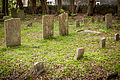 Old section of the cemetery
 -
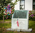 Memorial to veterans of Jamestown, RI
 -
 American Legion insignia on gate of cemetery


See also
- National Register of Historic Places listings in Newport County, Rhode Island
- List of cemeteries in Rhode Island
References
- ^ a b "National Register Information System". National Register of Historic Places. National Park Service. January 23, 2007.
- ^ "NRHP nomination for Artillery Park" (PDF). Rhode Island Preservation. Retrieved 2014-08-30.
External links
- Jamestown Philomenian Library – Historic and Architectural Resources of Jamestown, Rhode Island
- Town Cemetery at Find a Grave
| Topics | |
|---|---|
| Lists by state |
|
| Lists by insular areas | |
| Lists by associated state | |
| Other areas | |
| Related | |
Artillery Park | |
|
| |
| |
| Location | Jamestown, Rhode Island |
|---|---|
| Coordinates | 41°29′47″N 71°22′29″W / 41.49639°N 71.37472°W |
| Built | 1656 |
| NRHP reference No. | 73000054 [1] |
| Added to NRHP | March 7, 1973 |
The Artillery Park (also known as the Churchyard Cemetery and Historical Cemetery 2) is a historic cemetery at North Road and Narragansett Avenue in Jamestown, Rhode Island. It is located at a high point on the southern part of Conanicut Island. The cemetery was listed on the National Register of Historic Places in 1973. [1]
History
It was originally laid out in 1656 as a burying ground and militia training ground, but appears to have been used as a burying ground only since the 1740s. When British forces occupied the island in 1776, there was a brief skirmish there, and the British afterward used the area as a military staging ground. [2]
-
Old section of the cemetery
-
Memorial to veterans of Jamestown, RI
-
American Legion insignia on gate of cemetery
See also
- National Register of Historic Places listings in Newport County, Rhode Island
- List of cemeteries in Rhode Island
References
- ^ a b "National Register Information System". National Register of Historic Places. National Park Service. January 23, 2007.
- ^ "NRHP nomination for Artillery Park" (PDF). Rhode Island Preservation. Retrieved 2014-08-30.
External links
- Jamestown Philomenian Library – Historic and Architectural Resources of Jamestown, Rhode Island
- Town Cemetery at Find a Grave
| Topics | |
|---|---|
| Lists by state |
|
| Lists by insular areas | |
| Lists by associated state | |
| Other areas | |
| Related | |