Photos • Location

Ard, Arkansas | |
|---|---|
 Ard, Arkansas  Ard, Arkansas | |
| Coordinates: 35°08′41″N 93°11′31″W / 35.14472°N 93.19194°W | |
| Country | United States |
| State | Arkansas |
| County | Yell |
| Elevation | 459 ft (140 m) |
| Time zone | UTC-6 ( Central (CST)) |
| • Summer ( DST) | UTC-5 (CDT) |
| Area code | 479 |
| GNIS feature ID | 67853 [1] |
Ard is an unincorporated community in Yell County, Arkansas, United States. [1] The community is located along locally maintained Ard Road 5.7 miles (9.2 km) south-southwest of Dardanelle. [2]
Notes
- ^ a b c U.S. Geological Survey Geographic Names Information System: Ard, Arkansas
- ^ General Highway Map: Yell County, Arkansas (PDF) (Map). Arkansas State Highway and Transportation Department. November 27, 2002. Retrieved April 24, 2018.
Municipalities and communities of
Yell County, Arkansas, United States | ||
|---|---|---|
| Cities | 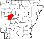 | |
| Town | ||
| CDPs | ||
|
Other unincorporated communities | ||
| Footnotes | ‡This populated place also has portions in an adjacent county or counties | |
|
| This article about a location in Yell County, Arkansas is a stub. You can help Wikipedia by expanding it. |
Ard, Arkansas | |
|---|---|
Ard, Arkansas Ard, Arkansas | |
| Coordinates: 35°08′41″N 93°11′31″W / 35.14472°N 93.19194°W | |
| Country | United States |
| State | Arkansas |
| County | Yell |
| Elevation | 459 ft (140 m) |
| Time zone | UTC-6 ( Central (CST)) |
| • Summer ( DST) | UTC-5 (CDT) |
| Area code | 479 |
| GNIS feature ID | 67853 [1] |
Ard is an unincorporated community in Yell County, Arkansas, United States. [1] The community is located along locally maintained Ard Road 5.7 miles (9.2 km) south-southwest of Dardanelle. [2]
Notes
- ^ a b c U.S. Geological Survey Geographic Names Information System: Ard, Arkansas
- ^ General Highway Map: Yell County, Arkansas (PDF) (Map). Arkansas State Highway and Transportation Department. November 27, 2002. Retrieved April 24, 2018.
Municipalities and communities of
Yell County, Arkansas, United States | ||
|---|---|---|
| Cities | | |
| Town | ||
| CDPs | ||
|
Other unincorporated communities | ||
| Footnotes | ‡This populated place also has portions in an adjacent county or counties | |
|
| This article about a location in Yell County, Arkansas is a stub. You can help Wikipedia by expanding it. |