| Arashan | |
|---|---|
 | |
| Location | |
| Country | Kyrgyzstan |
| Physical characteristics | |
| Source | Terskey Alatau |
| Mouth | Ak-Suu |
• coordinates | 42°28′25″N 78°31′54″E / 42.4736°N 78.5316°E |
| Basin features | |
| Progression | Ak-Suu→ Jyrgalang→ Issyk-Kul |
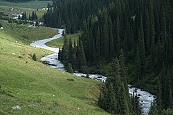
The Arashan ( Kyrgyz: Арашан), is a river in the Ak-Suu District, Issyk Kul Region, northeastern Kyrgyzstan. It flows north from the Terskey Alatau mountains, near Karakol and Issyk Kul Lake. It flows through Altyn Arashan, a mountain resort of hot springs and forested valley. [1] The Palatka Glacier looms over the river and valley. It flows into the river Ak-Suu, a tributary of the Jyrgalang.
References
- ^ Whittell, Giles (1995). Central Asia: the practical handbook. Cadogan. p. 228. ISBN 978-0-947754-53-2. Retrieved 22 November 2011.
External links
| Arashan | |
|---|---|
 | |
| Location | |
| Country | Kyrgyzstan |
| Physical characteristics | |
| Source | Terskey Alatau |
| Mouth | Ak-Suu |
• coordinates | 42°28′25″N 78°31′54″E / 42.4736°N 78.5316°E |
| Basin features | |
| Progression | Ak-Suu→ Jyrgalang→ Issyk-Kul |
The Arashan ( Kyrgyz: Арашан), is a river in the Ak-Suu District, Issyk Kul Region, northeastern Kyrgyzstan. It flows north from the Terskey Alatau mountains, near Karakol and Issyk Kul Lake. It flows through Altyn Arashan, a mountain resort of hot springs and forested valley. [1] The Palatka Glacier looms over the river and valley. It flows into the river Ak-Suu, a tributary of the Jyrgalang.
References
- ^ Whittell, Giles (1995). Central Asia: the practical handbook. Cadogan. p. 228. ISBN 978-0-947754-53-2. Retrieved 22 November 2011.
External links