This article needs additional citations for
verification. (June 2012) |
| Arad County | |
|---|---|
|
County of the
Kingdom of Hungary (~1200-1526) County of the Eastern Hungarian Kingdom (1526–1552) County of the Kingdom of Hungary (1741–1923) | |
 | |
| Capital |
Arad; Elek (1920–1923) |
| Area | |
| • Coordinates | 46°11′N 21°19′E / 46.183°N 21.317°E |
• 1910 | 6,048 km2 (2,335 sq mi) |
• 1920 | 270 km2 (100 sq mi) |
| Population | |
• 1910 | 414,388 |
• 1920 | 21,720 |
| History | |
• Established | 11th century |
• Ottoman conquest | 1552 |
• County recreated | 1741 |
| 4 June 1920 | |
• Merged into Csanád-Arad-Torontál County | 1923 |
| Today part of |
Romania (5,778 km2) Hungary (270 km2) |
.svg)
Arad County was an administrative unit in the Kingdom of Hungary, the Eastern Hungarian Kingdom and the Principality of Transylvania. The county was established along the Maros (Mureș) river in the 11th or the 12th century, but its first head, or ispán, was only mentioned in 1214. Its territory is now part of Romania, except a small area (the town of Elek and the surrounding villages) which is part of Hungary. The capital of the county was Arad.
Geography
.jpg)
The medieval Arad County was situated in the lands along both banks of the Maros (Mureș) River. [1] [2] The existence of arable lands, pastures, vineyards and orchards in the western lowlands in the Middle Ages is well-documented. [1] The hilly eastern regions were sparsely populated. [1] The total territory of the medieval county was around 3,800 km2 (1,500 sq mi). [3]
In 1744, Arad County absorbed a large part of Zaránd County, including its capital Zaránd/ Zărand (the remainder of Zarand County was then reorganized, with Körösbánya/ Baia de Criș as the new capital). In 1876, when the administrative structure of the Kingdom of Hungary was changed, the territory of Arad County was further modified to include the western third of the diminished Zaránd County, namely the Nagyhalmágy/ Hălmagiu district (Zarand County was disbanded altogether on that occasion).
Arad County shared borders with the Hungarian counties of Csanád, Békés, Bihar, Torda-Aranyos, Hunyad, Krassó-Szörény, Temes and Torontál. The river Mureș formed its southern border. Crişul Alb River flowed through the county. Its area was 6,078 km2 (2,347 sq mi) around 1910.
History
Origins
The Hungarians dominated the region of the Maros in the middle of the 10th century, according to the Byzantine Emperor Constantine Porphyrogenitus. [4] [5] Archaeological finds also shows that Hungarians settled in the plains along the river after their arrival in the Carpathian Basin at the end of the 9th century. [6] [7] Place names of Slavic origin, including Lipova (Lippa) and Zăbrani (Temeshidegkút), evidence the presence of Slavic speaking communities, especially in the region where the river, coming from the mountains, reached the lowlands. [8]
A powerful chieftain, Ajtony, ruled the territory along the rivers Danube, Maros and Tisza in the early 11th century. [9] [10] The Maros formed the northern border of Ajtony's realm, according to the Gesta Hungarorum, but the longer version of the Legend of Saint Gerard wrote that he controlled the lands as far as the Körös River. [11] Ajtony was killed in a battle against the army of Stephen I of Hungary, which was under the command of Csanád. [12] According to a scholarly theory, first proposed by historian György Györffy, Stephen I established Arad County after Ajtony's fall. [7] On the other hand, historian Gyula Kristó writes that Ajtony's whole realm was transformed into the large Csanád County during Stephen I's reign; Arad County only developed into a separate administrative unit in the second half of the 11th century or in the 12th century. [7] [2]
Middle Ages

The remains of an 11th-century stronghold, made of earth and timber, were found at Arad. [13] At an assembly held in Arad in 1131, the wife of King Béla the Blind, Helena of Rascia, ordered the massacre of 68 Hungarian lords. [14] Arad Castle and the estates attached to it were first documented in a royal charter, issued in 1177. [2] [7] The first known ispán, or head, of Arad County, Paul Csanád, was mentioned in a royal diploma, dated to 1214, but its authenticity is suspect. [2] The earliest authentic document that referred to an ispán of Arad was issued in 1240. [2] The western regions of the county were included in the Deanery of Arad of the Roman Catholic Diocese of Csanád; the Archdean of Arad was first mentioned in 1288. [15]
The earliest documents suggest that the kings owned most lands in the plains along the Maros. [16] However, the distribution of royal domains started at the end of the 11th century. [16] For instance, Ladislaus I of Hungary and his brother, Lampert, granted five villages to the Titel Chapter before 1095 and Béla the Blind established the Arad Chapter in the 1130s. [16] The Hodos clan was the only local noble kindred in the county; they were the patrons of the Hodoș-Bodrog Monastery. [16] Members of the Csanád, Csák and Dorozsma clans received estates in Arad County in the early 13th century. [16]
The effects of the Mongol invasion of Hungary cannot exactly be determined, but at least four monasteries disappeared. [16] Solymos Castle (in present-day Șoimoș in Lipova), the first fortress built by a nobleman in the county, was erected after the withdrawal of the Mongols. [16] Ecclesiastic institutions, prelates and lay lords – including the bishop of Csanád, the Arad Chapter and the Garais, Lackfis and Telegdis – held most former royal estates in the first half of the 14th century. [17] The existence of four elected "judges of the nobles" was first documented in 1311, proving that Arad County had transformed into a "noble county", an institution of the local noblemen's self-government. [3] [15]
Lippa (present-day Lipova) became the most prosperous settlement in the early 14th century: the tax payable by the local priest to the Holy See between 1333 and 1335 (266 dinars) was almost ten times higher than the average tax collected in other parishes. [18] The Slavs of the district of Lipova were converted into Catholicism in the middle of the century, according to John of Küküllő's contemporaneous chronicle. [18] The earliest Romanian place name in the county – Caprewar (now Căprioara) – was recorded in a list of the estates of the Telegdis which was completed in 1337. [18]
Modern Times

In 1920, the Treaty of Trianon assigned most of the territory of Arad county to Romania, except for a small area south of Békéscsaba, which became part of the newly formed Hungarian county of Csanád-Arad-Torontál in 1923. At the end of World War II, the Hungarian part of Arad county was merged into the recreated Csanád county, but in 1950 that county was split and its territory became part of Békés County.
The rest of the county is now part of the Arad County in Romania. This county also contains parts of the former counties Temes and Krassó-Szörény.
Demographics

| Census | Total | Romanian | Hungarian | German | Slovak | Other or unknown |
|---|---|---|---|---|---|---|
| 1880 [19] | 303,964 | 185,241 (63.35%) | 67,613 (23,12%) | 30,931 (10.58%) | 2,938 (1.00%) | 5,669 (1.94%) |
| 1890 [20] | 343,597 | 208,957 (60.81%) | 86,780 (25.26%) | 37,303 (10.86%) | 4,157 (1.21%) | 6,400 (1.86%) |
| 1900 [21] | 386,100 | 223,806 (57.97%) | 110,823 (28.70%) | 40,148 (10.40%) | 5,600 (1.45%) | 5,723 (1.48%) |
| 1910 [22] | 414,388 | 239,755 (57.86%) | 124,215 (29.98%) | 38,695 (9.34%) | 5,451 (1.32%) | 6,272 (1.51%) |
| Census | Total | Eastern Orthodox | Roman Catholic | Calvinist | Greek Catholic | Lutheran | Jewish | Other or unknown |
|---|---|---|---|---|---|---|---|---|
| 1880 | 303,964 | 186,758 (61.44%) | 75,304 (24.77%) | 17,519 (5.76%) | 11,079 (3.64%) | 5,151 (1.69%) | 8,018 (2.64%) | 135 (0.04%) |
| 1890 | 343,597 | 201,984 (58.79%) | 91,045 (26.50%) | 20,787 (6.05%) | 13,140 (3.82%) | 7,495 (2.18%) | 8,924 (2.60%) | 222 (0.06%) |
| 1900 | 386,100 | 215,904 (55.92%) | 109,523 (28.37%) | 24,849 (6.44%) | 15,134 (3.92%) | 9,954 (2.58%) | 10,085 (2.61%) | 651 (0.17%) |
| 1910 | 414,388 | 230,907 (55.72%) | 117,630 (28.39%) | 26,709 (6.45%) | 16,318 (3.94%) | 10,950 (2.64%) | 10,102 (2.44%) | 1,772 (0.43%) |
Subdivisions

In the early 20th century, the subdivisions of Arad county were:
| Districts (járás) | |
|---|---|
| District | Capital |
| Arad | Arad |
| Borosjenő | Borosjenő (now Ineu) |
| Borossebes | Borossebes (now Sebiş) |
| Elek | Elek |
| Kisjenő | Kisjenő (now Chișineu-Criș) |
| Magyarpécska | Magyarpécska (now Pecica) |
| Máriaradna | Máriaradna (now Radna) |
| Nagyhalmágy | Nagyhalmágy (now Hălmagiu) |
| Tornova | Tornova (now Târnova) |
| Világos | Világos (now Șiria) |
| Urban counties (törvényhatósági jogú város) | |
| Arad | |
Elek is now in Hungary. All the other towns mentioned are in Romania.
List of ispáns
Middle Ages
| Term | Incumbent | Monarch | Notes | Source |
|---|---|---|---|---|
| 1214 | Clement | Andrew II | son of Benedict from the kindred Csanád | [23] |
| 1238 | Paul | Béla IV | [23] | |
| 1240 | Saul | Béla IV | [23] | |
| c. 1310 | Alexander | Charles I | for voivode Ladislaus Kán; castellan of Solymos | [24] |
| 1311 | Dominic | Charles I | for voivode Ladislaus Kán; castellan of Solymos | [24] |
| 1319–1321 | Thomas Széchényi | Charles I | also master of the treasury for the Queen (1320–1321), voivode (1321–1342), castellan of Solymos | [24] |
| 1321–1372 | Arad County was administered by voivodes of Transylvania, who appointed deputies. | [24] | ||
| 1351 | Blaise Pósafi de Szer | Louis I | for duke Stephen, castellan of Hátszeg | [24] |
| 1391 | George Báthory | Sigismund | from the Somlyó branch | [25] |
| 1393–1401 | Arad County was administered by voivodes of Transylvania, who appointed deputies. | [25] | ||
| 1404–1426 | Pipo of Ozora | Sigismund | also ispán of Temes County | [25] |
| c. 1427 | Emeric Pálóci | Sigismund | [25] | |
| c. 1437 | John Országh de Guth | Sigismund | also castellan of Világosvár; ispán of Zaránd and Csongrád Counties | [25] |
| 1441–1444 | Ladislaus Maróti |
Vladislaus I Ladislaus V |
together with John Hunyadi (1443–1444); also ban of Macsó (1441–1443); ispán of Zaránd and Békés Counties | [25] [26] |
| 1443–1456 | John Hunyadi |
Vladislaus I Ladislaus V |
together with Ladislaus Maróti (1443–1444), with Nicholas Újlaki (1444–1446); also voivode (1443–1446); regent-governor of the Kingdom of Hungary (1446–1452) | [25] |
| 1444–1446 | Nicholas Újlaki | Ladislaus V | together with John Hunyadi; also voivode; ban of Severin (1445–1446) | [25] |
Habsburg rule
| Term | Incumbent | Monarch | Notes | Source |
|---|---|---|---|---|
| 1526–1527 | Gáspár Paksy |
Ferdinand I John I |
for John I, later Ferdinand I | |
| 1527–1614 | Unknown office-holders | [27] | ||
| 1614 | András Dóczy | Matthias II | also ispán of Szatmár County | [27] |
| 1614–1702 | Unknown office-holders | [27] | ||
| 1702–1713 | Ferenc Klobusiczky |
Leopold I Joseph I |
also chief justice (1702–1707); later Kuruc senator and ispán for Francis II Rákóczi | [27] |
| 1713–1736 | Pál Consbruch | Charles III | died in office | [27] |
| 1737–1743 | Unknown office-holder(s) | [27] | ||
| 1743–1744 | Zsigmond Andrássy | Maria Theresa | administrator | [27] |
| 1744–1751 | Antal Grassalkovich | Maria Theresa | also chief justice (1744–1748) | [27] |
| 1751–1788 | György Fekete |
Maria Theresa Joseph II |
also chief justice (1751–1762); vice-chancellor (1762–1773); master of the stewards (1766–1773); judge royal (1773–1783); director of the royal treasury (1782); died in office | [27] |
| 1788–1790 | Vacant | Joseph II | [27] | |
| 1790–1821 | Pál Almásy |
Leopold II Francis |
also master of the horse (1812–1821); poisoned | [27] |
| 1822–1830 | József Wenckheim | Francis | died in office | [27] |
| 1830–1837 | Lőrinc Orczy |
Francis Ferdinand V |
[27] | |
| 1837–1845 | István Szerencsy | Ferdinand V | [27] | |
| 1845–1848 | József Fascho de Lucsivna | Ferdinand V | [27] | |
| 1848–1849 | János Bohus de Világos | Ferdinand V | first term | [27] |
| 1849 | József Tomcsányi | Francis Joseph I | [27] | |
| 1849–1860 | Military District of Großwardein | |||
| 1860–1861 | János Bohus de Világos | Francis Joseph I | second term | |
| 1861–1867 | Vacant | Francis Joseph I | ||
| 1867–1869 | Béla Szende | Francis Joseph I | ||
| 1869–1871 | Vacant | Francis Joseph I | ||
| 1871–1878 | Péter Atzél | Francis Joseph I | resigned | |
| 1879–1886 | Károly Tabajdi | Francis Joseph I | died in office | |
| 1886– | László Fábián | Francis Joseph I | ||
| 1899–1905 | Iván Urbán | Francis Joseph I | first term; resigned | |
| 1906–1910 | Gyula Károlyi | Francis Joseph I | later prime minister (1931–1932) | |
| 1910–1915 | Iván Urbán | Francis Joseph I | second term; died in office | |
| 1915–1917 | Ferenc Baross |
Francis Joseph I Charles IV |
died in office | |
| 1917 | Béla Barabás | Charles IV | ||
| 1918– | Lajos Varjassy | |||
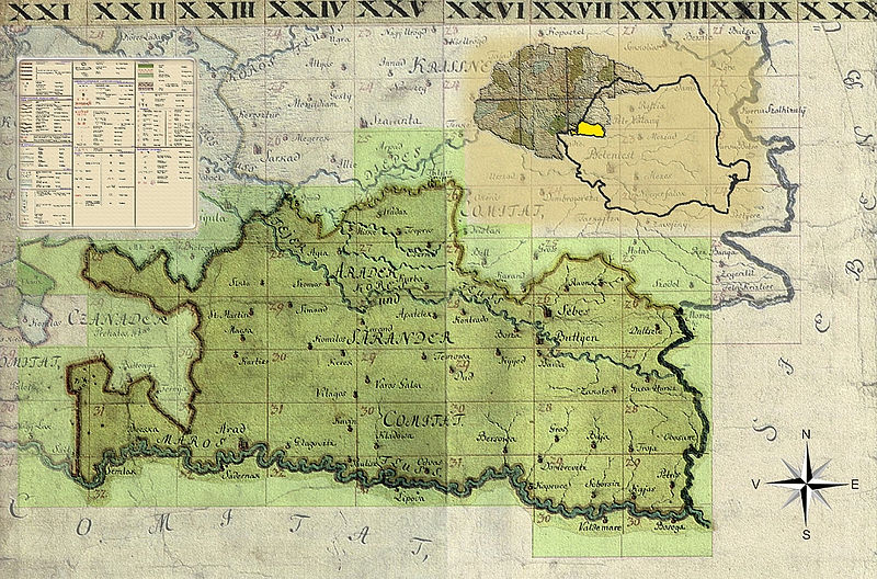
Clickable map of the Arad County, 1782–85
Notes
References
- ^ a b c Györffy 1987, p. 163.
- ^ a b c d e Kristó 1988, p. 462.
- ^ a b Györffy 1987, p. 167.
- ^ Bóna 1994, pp. 115–116.
- ^ Benkő 1994, pp. 53–54.
- ^ Bóna 1994, p. 116.
- ^ a b c d Benkő 1994, p. 54.
- ^ Györffy 1987, pp. 163–164.
- ^ Curta 2006, p. 248.
- ^ Györffy 1987, p. 164.
- ^ Kristó 1988, p. 459.
- ^ Curta 2006, p. 250.
- ^ Curta 2006, p. 251.
- ^ Bóna 1994, p. 143.
- ^ a b Kristó 1988, p. 463.
- ^ a b c d e f g Györffy 1987, p. 166.
- ^ Györffy 1987, pp. 166–167.
- ^ a b c Györffy 1987, p. 169.
- ^ "Az 1881. év elején végrehajtott népszámlálás főbb eredményei megyék és községek szerint rendezve, II. kötet (1882)". library.hungaricana.hu. Retrieved 28 September 2021.
- ^ "A Magyar Korona országainak helységnévtára (1892)". library.hungaricana.hu. Retrieved 29 September 2021.
- ^ "A MAGYAR KORONA ORSZÁGAINAK 1900". library.hungaricana.hu. Retrieved 29 September 2021.
- ^ "KlimoTheca :: Könyvtár". Kt.lib.pte.hu. Retrieved 29 September 2021.
- ^ a b c Zsoldos 2011, p. 125.
- ^ a b c d e Engel 1996, p. 97.
- ^ a b c d e f g h Engel 1996, p. 98.
- ^ Engel 1996, p. 30.
- ^ a b c d e f g h i j k l m n o p q Fallenbüchl 1994, p. 60.
Sources
- Benkő, Elek (1994). "Arad 2.". In Kristó, Gyula; Engel, Pál; Makk, Ferenc (eds.). Korai magyar történeti lexikon (9–14. század) [Encyclopedia of the Early Hungarian History (9th–14th centuries)] (in Hungarian). Akadémiai Kiadó. pp. 53–54. ISBN 963-05-6722-9.
- Bóna, István (1994). "The Hungarian–Slav Period (895–1172)". In Köpeczi, Béla; Barta, Gábor; Bóna, István; Makkai, László; Szász, Zoltán; Borus, Judit (eds.). History of Transylvania. Akadémiai Kiadó. pp. 109–177. ISBN 963-05-6703-2.
- Curta, Florin (2006). Southeastern Europe in the Middle Ages, 500-1250. Cambridge University Press. ISBN 978-0-521-89452-4.
- Engel, Pál (1996). Magyarország világi archontológiája, 1301–1457, I. [Secular Archontology of Hungary, 1301–1457, Volume I] (in Hungarian). História, MTA Történettudományi Intézete. ISBN 963-8312-44-0.
- Fallenbüchl, Zoltán (1994). Magyarország főispánjai, 1526–1848 [Lord-Lieutenants of Counties in Hungary, 1526–1848] (in Hungarian). Argumentum Kiadó. ISBN 963-7719-81-4.
- Györffy, György (1987). Az Árpád-kori Magyarország történeti földrajza, I: Abaújvár, Arad, Árva, Bács, Baranya, Bars, Békés, Bereg, Beszterce, Bihar, Bodrog, Borsod, Brassó, Csanád és Csongrád megye [Historical Geography of Hungary of the Árpáds, Volume I: The Counties of Abaújvár, Arad, Árva, Bács, Baranya, Bars, Békés, Bereg, Beszterce, Bihar, Bodrog, Borsod, Brassó, Csanád and Csongrád] (in Hungarian). Akadémiai Kiadó. ISBN 963-05-4200-5.
- Kristó, Gyula (1988). A vármegyék kialakulása Magyarországon [The Development of the Counties in Hungary] (in Hungarian). Magvető Kiadó. ISBN 963-14-1189-3.
- Zsoldos, Attila (2011). Magyarország világi archontológiája, 1000–1301. [Secular Archontology of Hungary, 1000–1301] (in Hungarian). História, MTA Történettudományi Intézete. ISBN 978-963-9627-38-3.

| International | |
|---|---|
| National | |
This article needs additional citations for
verification. (June 2012) |
| Arad County | |
|---|---|
|
County of the
Kingdom of Hungary (~1200-1526) County of the Eastern Hungarian Kingdom (1526–1552) County of the Kingdom of Hungary (1741–1923) | |
|
| |
| Capital |
Arad; Elek (1920–1923) |
| Area | |
| • Coordinates | 46°11′N 21°19′E / 46.183°N 21.317°E |
• 1910 | 6,048 km2 (2,335 sq mi) |
• 1920 | 270 km2 (100 sq mi) |
| Population | |
• 1910 | 414,388 |
• 1920 | 21,720 |
| History | |
• Established | 11th century |
• Ottoman conquest | 1552 |
• County recreated | 1741 |
| 4 June 1920 | |
• Merged into Csanád-Arad-Torontál County | 1923 |
| Today part of |
Romania (5,778 km2) Hungary (270 km2) |
Arad County was an administrative unit in the Kingdom of Hungary, the Eastern Hungarian Kingdom and the Principality of Transylvania. The county was established along the Maros (Mureș) river in the 11th or the 12th century, but its first head, or ispán, was only mentioned in 1214. Its territory is now part of Romania, except a small area (the town of Elek and the surrounding villages) which is part of Hungary. The capital of the county was Arad.
Geography
The medieval Arad County was situated in the lands along both banks of the Maros (Mureș) River. [1] [2] The existence of arable lands, pastures, vineyards and orchards in the western lowlands in the Middle Ages is well-documented. [1] The hilly eastern regions were sparsely populated. [1] The total territory of the medieval county was around 3,800 km2 (1,500 sq mi). [3]
In 1744, Arad County absorbed a large part of Zaránd County, including its capital Zaránd/ Zărand (the remainder of Zarand County was then reorganized, with Körösbánya/ Baia de Criș as the new capital). In 1876, when the administrative structure of the Kingdom of Hungary was changed, the territory of Arad County was further modified to include the western third of the diminished Zaránd County, namely the Nagyhalmágy/ Hălmagiu district (Zarand County was disbanded altogether on that occasion).
Arad County shared borders with the Hungarian counties of Csanád, Békés, Bihar, Torda-Aranyos, Hunyad, Krassó-Szörény, Temes and Torontál. The river Mureș formed its southern border. Crişul Alb River flowed through the county. Its area was 6,078 km2 (2,347 sq mi) around 1910.
History
Origins
The Hungarians dominated the region of the Maros in the middle of the 10th century, according to the Byzantine Emperor Constantine Porphyrogenitus. [4] [5] Archaeological finds also shows that Hungarians settled in the plains along the river after their arrival in the Carpathian Basin at the end of the 9th century. [6] [7] Place names of Slavic origin, including Lipova (Lippa) and Zăbrani (Temeshidegkút), evidence the presence of Slavic speaking communities, especially in the region where the river, coming from the mountains, reached the lowlands. [8]
A powerful chieftain, Ajtony, ruled the territory along the rivers Danube, Maros and Tisza in the early 11th century. [9] [10] The Maros formed the northern border of Ajtony's realm, according to the Gesta Hungarorum, but the longer version of the Legend of Saint Gerard wrote that he controlled the lands as far as the Körös River. [11] Ajtony was killed in a battle against the army of Stephen I of Hungary, which was under the command of Csanád. [12] According to a scholarly theory, first proposed by historian György Györffy, Stephen I established Arad County after Ajtony's fall. [7] On the other hand, historian Gyula Kristó writes that Ajtony's whole realm was transformed into the large Csanád County during Stephen I's reign; Arad County only developed into a separate administrative unit in the second half of the 11th century or in the 12th century. [7] [2]
Middle Ages
The remains of an 11th-century stronghold, made of earth and timber, were found at Arad. [13] At an assembly held in Arad in 1131, the wife of King Béla the Blind, Helena of Rascia, ordered the massacre of 68 Hungarian lords. [14] Arad Castle and the estates attached to it were first documented in a royal charter, issued in 1177. [2] [7] The first known ispán, or head, of Arad County, Paul Csanád, was mentioned in a royal diploma, dated to 1214, but its authenticity is suspect. [2] The earliest authentic document that referred to an ispán of Arad was issued in 1240. [2] The western regions of the county were included in the Deanery of Arad of the Roman Catholic Diocese of Csanád; the Archdean of Arad was first mentioned in 1288. [15]
The earliest documents suggest that the kings owned most lands in the plains along the Maros. [16] However, the distribution of royal domains started at the end of the 11th century. [16] For instance, Ladislaus I of Hungary and his brother, Lampert, granted five villages to the Titel Chapter before 1095 and Béla the Blind established the Arad Chapter in the 1130s. [16] The Hodos clan was the only local noble kindred in the county; they were the patrons of the Hodoș-Bodrog Monastery. [16] Members of the Csanád, Csák and Dorozsma clans received estates in Arad County in the early 13th century. [16]
The effects of the Mongol invasion of Hungary cannot exactly be determined, but at least four monasteries disappeared. [16] Solymos Castle (in present-day Șoimoș in Lipova), the first fortress built by a nobleman in the county, was erected after the withdrawal of the Mongols. [16] Ecclesiastic institutions, prelates and lay lords – including the bishop of Csanád, the Arad Chapter and the Garais, Lackfis and Telegdis – held most former royal estates in the first half of the 14th century. [17] The existence of four elected "judges of the nobles" was first documented in 1311, proving that Arad County had transformed into a "noble county", an institution of the local noblemen's self-government. [3] [15]
Lippa (present-day Lipova) became the most prosperous settlement in the early 14th century: the tax payable by the local priest to the Holy See between 1333 and 1335 (266 dinars) was almost ten times higher than the average tax collected in other parishes. [18] The Slavs of the district of Lipova were converted into Catholicism in the middle of the century, according to John of Küküllő's contemporaneous chronicle. [18] The earliest Romanian place name in the county – Caprewar (now Căprioara) – was recorded in a list of the estates of the Telegdis which was completed in 1337. [18]
Modern Times
In 1920, the Treaty of Trianon assigned most of the territory of Arad county to Romania, except for a small area south of Békéscsaba, which became part of the newly formed Hungarian county of Csanád-Arad-Torontál in 1923. At the end of World War II, the Hungarian part of Arad county was merged into the recreated Csanád county, but in 1950 that county was split and its territory became part of Békés County.
The rest of the county is now part of the Arad County in Romania. This county also contains parts of the former counties Temes and Krassó-Szörény.
Demographics
| Census | Total | Romanian | Hungarian | German | Slovak | Other or unknown |
|---|---|---|---|---|---|---|
| 1880 [19] | 303,964 | 185,241 (63.35%) | 67,613 (23,12%) | 30,931 (10.58%) | 2,938 (1.00%) | 5,669 (1.94%) |
| 1890 [20] | 343,597 | 208,957 (60.81%) | 86,780 (25.26%) | 37,303 (10.86%) | 4,157 (1.21%) | 6,400 (1.86%) |
| 1900 [21] | 386,100 | 223,806 (57.97%) | 110,823 (28.70%) | 40,148 (10.40%) | 5,600 (1.45%) | 5,723 (1.48%) |
| 1910 [22] | 414,388 | 239,755 (57.86%) | 124,215 (29.98%) | 38,695 (9.34%) | 5,451 (1.32%) | 6,272 (1.51%) |
| Census | Total | Eastern Orthodox | Roman Catholic | Calvinist | Greek Catholic | Lutheran | Jewish | Other or unknown |
|---|---|---|---|---|---|---|---|---|
| 1880 | 303,964 | 186,758 (61.44%) | 75,304 (24.77%) | 17,519 (5.76%) | 11,079 (3.64%) | 5,151 (1.69%) | 8,018 (2.64%) | 135 (0.04%) |
| 1890 | 343,597 | 201,984 (58.79%) | 91,045 (26.50%) | 20,787 (6.05%) | 13,140 (3.82%) | 7,495 (2.18%) | 8,924 (2.60%) | 222 (0.06%) |
| 1900 | 386,100 | 215,904 (55.92%) | 109,523 (28.37%) | 24,849 (6.44%) | 15,134 (3.92%) | 9,954 (2.58%) | 10,085 (2.61%) | 651 (0.17%) |
| 1910 | 414,388 | 230,907 (55.72%) | 117,630 (28.39%) | 26,709 (6.45%) | 16,318 (3.94%) | 10,950 (2.64%) | 10,102 (2.44%) | 1,772 (0.43%) |
Subdivisions
In the early 20th century, the subdivisions of Arad county were:
| Districts (járás) | |
|---|---|
| District | Capital |
| Arad | Arad |
| Borosjenő | Borosjenő (now Ineu) |
| Borossebes | Borossebes (now Sebiş) |
| Elek | Elek |
| Kisjenő | Kisjenő (now Chișineu-Criș) |
| Magyarpécska | Magyarpécska (now Pecica) |
| Máriaradna | Máriaradna (now Radna) |
| Nagyhalmágy | Nagyhalmágy (now Hălmagiu) |
| Tornova | Tornova (now Târnova) |
| Világos | Világos (now Șiria) |
| Urban counties (törvényhatósági jogú város) | |
| Arad | |
Elek is now in Hungary. All the other towns mentioned are in Romania.
List of ispáns
Middle Ages
| Term | Incumbent | Monarch | Notes | Source |
|---|---|---|---|---|
| 1214 | Clement | Andrew II | son of Benedict from the kindred Csanád | [23] |
| 1238 | Paul | Béla IV | [23] | |
| 1240 | Saul | Béla IV | [23] | |
| c. 1310 | Alexander | Charles I | for voivode Ladislaus Kán; castellan of Solymos | [24] |
| 1311 | Dominic | Charles I | for voivode Ladislaus Kán; castellan of Solymos | [24] |
| 1319–1321 | Thomas Széchényi | Charles I | also master of the treasury for the Queen (1320–1321), voivode (1321–1342), castellan of Solymos | [24] |
| 1321–1372 | Arad County was administered by voivodes of Transylvania, who appointed deputies. | [24] | ||
| 1351 | Blaise Pósafi de Szer | Louis I | for duke Stephen, castellan of Hátszeg | [24] |
| 1391 | George Báthory | Sigismund | from the Somlyó branch | [25] |
| 1393–1401 | Arad County was administered by voivodes of Transylvania, who appointed deputies. | [25] | ||
| 1404–1426 | Pipo of Ozora | Sigismund | also ispán of Temes County | [25] |
| c. 1427 | Emeric Pálóci | Sigismund | [25] | |
| c. 1437 | John Országh de Guth | Sigismund | also castellan of Világosvár; ispán of Zaránd and Csongrád Counties | [25] |
| 1441–1444 | Ladislaus Maróti |
Vladislaus I Ladislaus V |
together with John Hunyadi (1443–1444); also ban of Macsó (1441–1443); ispán of Zaránd and Békés Counties | [25] [26] |
| 1443–1456 | John Hunyadi |
Vladislaus I Ladislaus V |
together with Ladislaus Maróti (1443–1444), with Nicholas Újlaki (1444–1446); also voivode (1443–1446); regent-governor of the Kingdom of Hungary (1446–1452) | [25] |
| 1444–1446 | Nicholas Újlaki | Ladislaus V | together with John Hunyadi; also voivode; ban of Severin (1445–1446) | [25] |
Habsburg rule
| Term | Incumbent | Monarch | Notes | Source |
|---|---|---|---|---|
| 1526–1527 | Gáspár Paksy |
Ferdinand I John I |
for John I, later Ferdinand I | |
| 1527–1614 | Unknown office-holders | [27] | ||
| 1614 | András Dóczy | Matthias II | also ispán of Szatmár County | [27] |
| 1614–1702 | Unknown office-holders | [27] | ||
| 1702–1713 | Ferenc Klobusiczky |
Leopold I Joseph I |
also chief justice (1702–1707); later Kuruc senator and ispán for Francis II Rákóczi | [27] |
| 1713–1736 | Pál Consbruch | Charles III | died in office | [27] |
| 1737–1743 | Unknown office-holder(s) | [27] | ||
| 1743–1744 | Zsigmond Andrássy | Maria Theresa | administrator | [27] |
| 1744–1751 | Antal Grassalkovich | Maria Theresa | also chief justice (1744–1748) | [27] |
| 1751–1788 | György Fekete |
Maria Theresa Joseph II |
also chief justice (1751–1762); vice-chancellor (1762–1773); master of the stewards (1766–1773); judge royal (1773–1783); director of the royal treasury (1782); died in office | [27] |
| 1788–1790 | Vacant | Joseph II | [27] | |
| 1790–1821 | Pál Almásy |
Leopold II Francis |
also master of the horse (1812–1821); poisoned | [27] |
| 1822–1830 | József Wenckheim | Francis | died in office | [27] |
| 1830–1837 | Lőrinc Orczy |
Francis Ferdinand V |
[27] | |
| 1837–1845 | István Szerencsy | Ferdinand V | [27] | |
| 1845–1848 | József Fascho de Lucsivna | Ferdinand V | [27] | |
| 1848–1849 | János Bohus de Világos | Ferdinand V | first term | [27] |
| 1849 | József Tomcsányi | Francis Joseph I | [27] | |
| 1849–1860 | Military District of Großwardein | |||
| 1860–1861 | János Bohus de Világos | Francis Joseph I | second term | |
| 1861–1867 | Vacant | Francis Joseph I | ||
| 1867–1869 | Béla Szende | Francis Joseph I | ||
| 1869–1871 | Vacant | Francis Joseph I | ||
| 1871–1878 | Péter Atzél | Francis Joseph I | resigned | |
| 1879–1886 | Károly Tabajdi | Francis Joseph I | died in office | |
| 1886– | László Fábián | Francis Joseph I | ||
| 1899–1905 | Iván Urbán | Francis Joseph I | first term; resigned | |
| 1906–1910 | Gyula Károlyi | Francis Joseph I | later prime minister (1931–1932) | |
| 1910–1915 | Iván Urbán | Francis Joseph I | second term; died in office | |
| 1915–1917 | Ferenc Baross |
Francis Joseph I Charles IV |
died in office | |
| 1917 | Béla Barabás | Charles IV | ||
| 1918– | Lajos Varjassy | |||
Clickable map of the Arad County, 1782–85
Notes
References
- ^ a b c Györffy 1987, p. 163.
- ^ a b c d e Kristó 1988, p. 462.
- ^ a b Györffy 1987, p. 167.
- ^ Bóna 1994, pp. 115–116.
- ^ Benkő 1994, pp. 53–54.
- ^ Bóna 1994, p. 116.
- ^ a b c d Benkő 1994, p. 54.
- ^ Györffy 1987, pp. 163–164.
- ^ Curta 2006, p. 248.
- ^ Györffy 1987, p. 164.
- ^ Kristó 1988, p. 459.
- ^ Curta 2006, p. 250.
- ^ Curta 2006, p. 251.
- ^ Bóna 1994, p. 143.
- ^ a b Kristó 1988, p. 463.
- ^ a b c d e f g Györffy 1987, p. 166.
- ^ Györffy 1987, pp. 166–167.
- ^ a b c Györffy 1987, p. 169.
- ^ "Az 1881. év elején végrehajtott népszámlálás főbb eredményei megyék és községek szerint rendezve, II. kötet (1882)". library.hungaricana.hu. Retrieved 28 September 2021.
- ^ "A Magyar Korona országainak helységnévtára (1892)". library.hungaricana.hu. Retrieved 29 September 2021.
- ^ "A MAGYAR KORONA ORSZÁGAINAK 1900". library.hungaricana.hu. Retrieved 29 September 2021.
- ^ "KlimoTheca :: Könyvtár". Kt.lib.pte.hu. Retrieved 29 September 2021.
- ^ a b c Zsoldos 2011, p. 125.
- ^ a b c d e Engel 1996, p. 97.
- ^ a b c d e f g h Engel 1996, p. 98.
- ^ Engel 1996, p. 30.
- ^ a b c d e f g h i j k l m n o p q Fallenbüchl 1994, p. 60.
Sources
- Benkő, Elek (1994). "Arad 2.". In Kristó, Gyula; Engel, Pál; Makk, Ferenc (eds.). Korai magyar történeti lexikon (9–14. század) [Encyclopedia of the Early Hungarian History (9th–14th centuries)] (in Hungarian). Akadémiai Kiadó. pp. 53–54. ISBN 963-05-6722-9.
- Bóna, István (1994). "The Hungarian–Slav Period (895–1172)". In Köpeczi, Béla; Barta, Gábor; Bóna, István; Makkai, László; Szász, Zoltán; Borus, Judit (eds.). History of Transylvania. Akadémiai Kiadó. pp. 109–177. ISBN 963-05-6703-2.
- Curta, Florin (2006). Southeastern Europe in the Middle Ages, 500-1250. Cambridge University Press. ISBN 978-0-521-89452-4.
- Engel, Pál (1996). Magyarország világi archontológiája, 1301–1457, I. [Secular Archontology of Hungary, 1301–1457, Volume I] (in Hungarian). História, MTA Történettudományi Intézete. ISBN 963-8312-44-0.
- Fallenbüchl, Zoltán (1994). Magyarország főispánjai, 1526–1848 [Lord-Lieutenants of Counties in Hungary, 1526–1848] (in Hungarian). Argumentum Kiadó. ISBN 963-7719-81-4.
- Györffy, György (1987). Az Árpád-kori Magyarország történeti földrajza, I: Abaújvár, Arad, Árva, Bács, Baranya, Bars, Békés, Bereg, Beszterce, Bihar, Bodrog, Borsod, Brassó, Csanád és Csongrád megye [Historical Geography of Hungary of the Árpáds, Volume I: The Counties of Abaújvár, Arad, Árva, Bács, Baranya, Bars, Békés, Bereg, Beszterce, Bihar, Bodrog, Borsod, Brassó, Csanád and Csongrád] (in Hungarian). Akadémiai Kiadó. ISBN 963-05-4200-5.
- Kristó, Gyula (1988). A vármegyék kialakulása Magyarországon [The Development of the Counties in Hungary] (in Hungarian). Magvető Kiadó. ISBN 963-14-1189-3.
- Zsoldos, Attila (2011). Magyarország világi archontológiája, 1000–1301. [Secular Archontology of Hungary, 1000–1301] (in Hungarian). História, MTA Történettudományi Intézete. ISBN 978-963-9627-38-3.
| International | |
|---|---|
| National | |