Photos • Location
(Redirected from
Arabie Dam)
| Flag Boshielo Dam Arabie Dam | |
|---|---|
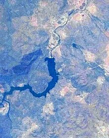
 Seen from space, 2012 | |
| Official name | Flag Boshielo Dam |
| Location | Limpopo, South Africa |
| Coordinates | 24°47′0″S 29°25′40″E / 24.78333°S 29.42778°E |
| Opening date | 1987 |
| Operator(s) | Department of Water Affairs and Forestry |
| Dam and spillways | |
| Impounds | Olifants River |
| Height | 36 m |
| Length | 1225 m |
| Reservoir | |
| Creates | Flag Boshielo Dam Reservoir |
| Total capacity | 185 100 000 m³ |
| Surface area | 1288 ha |
Flag Boshielo Dam is a water reservoir on the Olifants River, near Marble Hall, Limpopo, South Africa. It was established in 1987 and is named after activist Flag Boshielo.
See also
References
(Redirected from
Arabie Dam)
| Flag Boshielo Dam Arabie Dam | |
|---|---|
 Seen from space, 2012 | |
| Official name | Flag Boshielo Dam |
| Location | Limpopo, South Africa |
| Coordinates | 24°47′0″S 29°25′40″E / 24.78333°S 29.42778°E |
| Opening date | 1987 |
| Operator(s) | Department of Water Affairs and Forestry |
| Dam and spillways | |
| Impounds | Olifants River |
| Height | 36 m |
| Length | 1225 m |
| Reservoir | |
| Creates | Flag Boshielo Dam Reservoir |
| Total capacity | 185 100 000 m³ |
| Surface area | 1288 ha |
Flag Boshielo Dam is a water reservoir on the Olifants River, near Marble Hall, Limpopo, South Africa. It was established in 1987 and is named after activist Flag Boshielo.
See also
References