Aqqala County
Persian: شهرستان آققلا | |
|---|---|
 Location of Aqqala County in Golestan Province (center left, green) | |
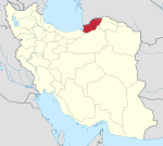
 Location of Golestan Province in Iran | |
| Coordinates: 37°12′N 54°34′E / 37.200°N 54.567°E [1] | |
| Country | |
| Province | Golestan |
| Capital | Aqqala |
| Districts | Central, Voshmgir |
| Population (2016)
[2] | |
| • Total | 132,733 |
| Time zone | UTC+3:30 ( IRST) |
| Aqqala County at GEOnet Names Server | |
Aqqala County ( Persian: شهرستان آققلا) is in Golestan Province, Iran. Its capital is the city of Aqqala. [3]
Demographics
Population
At the time of the 2006 National Census, the county's population was 109,440 in 22,804 households. [4] The following census in 2011 counted 124,185 people in 31,817 households. [5] The 2016 census measured the population of the county as 132,733 in 35,989 households. [2]
Administrative divisions
Aqqala County's population history and administrative structure over three consecutive censuses are shown in the following table.
| Administrative Divisions | 2006 [4] | 2011 [5] | 2016 [2] |
|---|---|---|---|
| Central District | 84,291 | 94,944 | 101,988 |
| Aq Altin RD | 19,030 | 21,460 | 22,020 |
| Gorganbuy RD | 24,950 | 27,343 | 29,201 |
| Sheykh Musa RD | 12,909 | 14,515 | 15,651 |
| Aqqala (city) | 27,402 | 31,626 | 35,116 |
| Voshmgir District | 25,149 | 29,241 | 30,745 |
| Mazraeh-ye Jonubi RD | 5,891 | 7,008 | 7,681 |
| Mazraeh-ye Shomali RD [a] | 13,399 | 15,693 | 16,061 |
| Anbar Olum (city) | 5,859 | 6,540 | 7,003 |
| Total | 109,440 | 124,185 | 132,733 |
| RD = Rural District | |||
See also
![]() Media related to
Aqqala County at Wikimedia Commons
Media related to
Aqqala County at Wikimedia Commons
Notes
- ^ Formerly Mazraeh Rural District
References
- ^ OpenStreetMap contributors (11 October 2023). "Aqqala County" (Map). OpenStreetMap (in Persian). Retrieved 11 October 2023.
- ^ a b c "Census of the Islamic Republic of Iran, 1395 (2016)". AMAR (in Persian). The Statistical Center of Iran. p. 27. Archived from the original (Excel) on 29 March 2019. Retrieved 19 December 2022.
- ^ Habibi, Hassan (31 January 1379). "Creating divisional changes and reforms in Golestan province". Lamtakam (in Persian). Ministry of Interior, Council of Ministers. Archived from the original on 18 December 2023. Retrieved 13 February 2024.
- ^ a b "Census of the Islamic Republic of Iran, 1385 (2006)". AMAR (in Persian). The Statistical Center of Iran. p. 27. Archived from the original (Excel) on 20 September 2011. Retrieved 25 September 2022.
- ^ a b "Census of the Islamic Republic of Iran, 1390 (2011)". Syracuse University (in Persian). The Statistical Center of Iran. p. 27. Archived from the original (Excel) on 17 January 2023. Retrieved 19 December 2022.
Aqqala County
Persian: شهرستان آققلا | |
|---|---|
 Location of Aqqala County in Golestan Province (center left, green) | |
 Location of Golestan Province in Iran | |
| Coordinates: 37°12′N 54°34′E / 37.200°N 54.567°E [1] | |
| Country | |
| Province | Golestan |
| Capital | Aqqala |
| Districts | Central, Voshmgir |
| Population (2016)
[2] | |
| • Total | 132,733 |
| Time zone | UTC+3:30 ( IRST) |
| Aqqala County at GEOnet Names Server | |
Aqqala County ( Persian: شهرستان آققلا) is in Golestan Province, Iran. Its capital is the city of Aqqala. [3]
Demographics
Population
At the time of the 2006 National Census, the county's population was 109,440 in 22,804 households. [4] The following census in 2011 counted 124,185 people in 31,817 households. [5] The 2016 census measured the population of the county as 132,733 in 35,989 households. [2]
Administrative divisions
Aqqala County's population history and administrative structure over three consecutive censuses are shown in the following table.
| Administrative Divisions | 2006 [4] | 2011 [5] | 2016 [2] |
|---|---|---|---|
| Central District | 84,291 | 94,944 | 101,988 |
| Aq Altin RD | 19,030 | 21,460 | 22,020 |
| Gorganbuy RD | 24,950 | 27,343 | 29,201 |
| Sheykh Musa RD | 12,909 | 14,515 | 15,651 |
| Aqqala (city) | 27,402 | 31,626 | 35,116 |
| Voshmgir District | 25,149 | 29,241 | 30,745 |
| Mazraeh-ye Jonubi RD | 5,891 | 7,008 | 7,681 |
| Mazraeh-ye Shomali RD [a] | 13,399 | 15,693 | 16,061 |
| Anbar Olum (city) | 5,859 | 6,540 | 7,003 |
| Total | 109,440 | 124,185 | 132,733 |
| RD = Rural District | |||
See also
![]() Media related to
Aqqala County at Wikimedia Commons
Media related to
Aqqala County at Wikimedia Commons
Notes
- ^ Formerly Mazraeh Rural District
References
- ^ OpenStreetMap contributors (11 October 2023). "Aqqala County" (Map). OpenStreetMap (in Persian). Retrieved 11 October 2023.
- ^ a b c "Census of the Islamic Republic of Iran, 1395 (2016)". AMAR (in Persian). The Statistical Center of Iran. p. 27. Archived from the original (Excel) on 29 March 2019. Retrieved 19 December 2022.
- ^ Habibi, Hassan (31 January 1379). "Creating divisional changes and reforms in Golestan province". Lamtakam (in Persian). Ministry of Interior, Council of Ministers. Archived from the original on 18 December 2023. Retrieved 13 February 2024.
- ^ a b "Census of the Islamic Republic of Iran, 1385 (2006)". AMAR (in Persian). The Statistical Center of Iran. p. 27. Archived from the original (Excel) on 20 September 2011. Retrieved 25 September 2022.
- ^ a b "Census of the Islamic Republic of Iran, 1390 (2011)". Syracuse University (in Persian). The Statistical Center of Iran. p. 27. Archived from the original (Excel) on 17 January 2023. Retrieved 19 December 2022.
