Appel | |
|---|---|
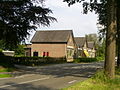
 Gristmill De Hoop | |
 Appel Location in the Netherlands  Appel Appel (Netherlands) | |
| Coordinates: 52°11′15″N 5°32′25″E / 52.18750°N 5.54028°E | |
| Country | Netherlands |
| Province | Gelderland |
| Municipality | Nijkerk |
| Area | |
| • Total | 10.75 km2 (4.15 sq mi) |
| Population | |
| • Total | 705 |
| • Density | 66/km2 (170/sq mi) |
| Time zone | UTC+1 ( CET) |
| • Summer ( DST) | UTC+2 ( CEST) |
| Postal code | 3862
[1] |
| Dialing code | 033 |
Appel (literally "apple") is a hamlet in the Dutch province of Gelderland. [2] It is located in the municipality Nijkerk, about 6 km southeast of the city, on the border with the municipality of Barneveld. [3]
It was first mentioned in 1146 as Appele. The etymology is unclear and may not be related to apples. [4] The postal authorities have placed it under Nijkerk. [5] In 1840, it was home to 318 people. [6] The grist mill De Hoop was constructed in 1888 and was restored in 2004. [7] In 2007, remains of a wooden castle were found near Appel which dated from around 1100. The hamlet consists of about 60 houses. [6]
Gallery
-
 School in Appel
 -
 Place name sign


References
- ^
a
b
c
"Kerncijfers wijken en buurten 2021". Central Bureau of Statistics. Retrieved 23 March 2022.
combined listing with 't Woud
- ^ VUGA's Alfabetische Plaatsnamengids van Nederland (13th edition), VUGA, 1997.
- ^ ANWB Topografische Atlas Nederland, Topografische Dienst and ANWB, 2005.
- ^ "Appel - (geografische naam)". Etymologiebank (in Dutch). Retrieved 23 March 2022.
- ^ "Postcode 3862 in Nijkerk". Postcode bij adres (in Dutch). Retrieved 23 March 2022.
- ^ a b "Appel". Plaatsengids (in Dutch). Retrieved 23 March 2022.
- ^ "De Hoop". Molen database (in Dutch). Retrieved 23 March 2022.
|
| This Gelderland location article is a stub. You can help Wikipedia by expanding it. |
Appel | |
|---|---|
|
Gristmill De Hoop | |
Appel Location in the Netherlands Appel Appel (Netherlands) | |
| Coordinates: 52°11′15″N 5°32′25″E / 52.18750°N 5.54028°E | |
| Country | Netherlands |
| Province | Gelderland |
| Municipality | Nijkerk |
| Area | |
| • Total | 10.75 km2 (4.15 sq mi) |
| Population | |
| • Total | 705 |
| • Density | 66/km2 (170/sq mi) |
| Time zone | UTC+1 ( CET) |
| • Summer ( DST) | UTC+2 ( CEST) |
| Postal code | 3862
[1] |
| Dialing code | 033 |
Appel (literally "apple") is a hamlet in the Dutch province of Gelderland. [2] It is located in the municipality Nijkerk, about 6 km southeast of the city, on the border with the municipality of Barneveld. [3]
It was first mentioned in 1146 as Appele. The etymology is unclear and may not be related to apples. [4] The postal authorities have placed it under Nijkerk. [5] In 1840, it was home to 318 people. [6] The grist mill De Hoop was constructed in 1888 and was restored in 2004. [7] In 2007, remains of a wooden castle were found near Appel which dated from around 1100. The hamlet consists of about 60 houses. [6]
Gallery
-
School in Appel
-
Place name sign
References
- ^
a
b
c
"Kerncijfers wijken en buurten 2021". Central Bureau of Statistics. Retrieved 23 March 2022.
combined listing with 't Woud
- ^ VUGA's Alfabetische Plaatsnamengids van Nederland (13th edition), VUGA, 1997.
- ^ ANWB Topografische Atlas Nederland, Topografische Dienst and ANWB, 2005.
- ^ "Appel - (geografische naam)". Etymologiebank (in Dutch). Retrieved 23 March 2022.
- ^ "Postcode 3862 in Nijkerk". Postcode bij adres (in Dutch). Retrieved 23 March 2022.
- ^ a b "Appel". Plaatsengids (in Dutch). Retrieved 23 March 2022.
- ^ "De Hoop". Molen database (in Dutch). Retrieved 23 March 2022.
|
| This Gelderland location article is a stub. You can help Wikipedia by expanding it. |