You can help expand this article with text translated from
the corresponding article in Lithuanian. (October 2011) Click [show] for important translation instructions.
|
| Anykšta | |
|---|---|
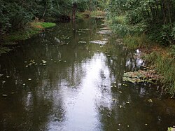
 The Anykšta near its source | |
| Location | |
| Country | Lithuania |
| Location | Anykščiai district municipality, Utena County |
| Physical characteristics | |
| Source | |
| • location | Rubikiai Lake |
| Mouth | |
• coordinates | 55°31′52″N 25°06′47″E / 55.5312°N 25.1131°E |
| Length | 13.8 km (8.6 mi) [1] |
| Basin size | 144.9 km2 (55.9 sq mi) [1] |
| Discharge | |
| • average | 1.18 m³/s |
| Basin features | |
| Progression | Šventoji→ Neris→ Neman→ Baltic Sea |
The Anykšta is a river of Anykščiai district municipality, Utena County, in northeastern Lithuania. It flows for 13.8 kilometres and has a basin area of 144.9 km².
The Anykšta is a left-bank tributary of the Šventoji, joining it in the town of Anykščiai.
The name Anykšta is of unknown origin. According to one theory, it could have been derived from Proto-Indoeuropean root *an-/*en- related to water. [2]
- ^
a
b B. Gailiušis, J. Jablonskis, M Kovalenkovienė (2001). Lietuvos upės (in Lithuanian). Kaunas: Lietuvos energetikos institutas. p. 507.
{{
cite book}}
: CS1 maint: multiple names: authors list ( link) - ^ Vanagas, Aleksandras (1981). Lietuvių hidronimų etimologinis žodynas (in Lithuanian). Vilnius: Mokslas.
LIETUVOS RESPUBLIKOS UPIŲ IR TVENKINIŲ KLASIFIKATORIUS (Republic of Lithuania- River and Pond Classifications) Archived 2017-03-29 at the Wayback Machine. Ministry of Environment (Lithuania). Accessed 2011-11-11.
You can help expand this article with text translated from
the corresponding article in Lithuanian. (October 2011) Click [show] for important translation instructions.
|
| Anykšta | |
|---|---|
 The Anykšta near its source | |
| Location | |
| Country | Lithuania |
| Location | Anykščiai district municipality, Utena County |
| Physical characteristics | |
| Source | |
| • location | Rubikiai Lake |
| Mouth | |
• coordinates | 55°31′52″N 25°06′47″E / 55.5312°N 25.1131°E |
| Length | 13.8 km (8.6 mi) [1] |
| Basin size | 144.9 km2 (55.9 sq mi) [1] |
| Discharge | |
| • average | 1.18 m³/s |
| Basin features | |
| Progression | Šventoji→ Neris→ Neman→ Baltic Sea |
The Anykšta is a river of Anykščiai district municipality, Utena County, in northeastern Lithuania. It flows for 13.8 kilometres and has a basin area of 144.9 km².
The Anykšta is a left-bank tributary of the Šventoji, joining it in the town of Anykščiai.
The name Anykšta is of unknown origin. According to one theory, it could have been derived from Proto-Indoeuropean root *an-/*en- related to water. [2]
- ^
a
b B. Gailiušis, J. Jablonskis, M Kovalenkovienė (2001). Lietuvos upės (in Lithuanian). Kaunas: Lietuvos energetikos institutas. p. 507.
{{
cite book}}
: CS1 maint: multiple names: authors list ( link) - ^ Vanagas, Aleksandras (1981). Lietuvių hidronimų etimologinis žodynas (in Lithuanian). Vilnius: Mokslas.
LIETUVOS RESPUBLIKOS UPIŲ IR TVENKINIŲ KLASIFIKATORIUS (Republic of Lithuania- River and Pond Classifications) Archived 2017-03-29 at the Wayback Machine. Ministry of Environment (Lithuania). Accessed 2011-11-11.