Photos • Location
| Angren | |
|---|---|
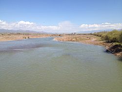
 Angren river in
Ohangaron | |
| Location | |
| Country | Uzbekistan |
| Physical characteristics | |
| Mouth | Syr Darya |
• coordinates | 40°47′32″N 68°49′56″E / 40.7922°N 68.8322°E |
| Length | 223 km (139 mi) |
| Basin size | 5,260 km2 (2,030 sq mi) |
| Basin features | |
| Progression | Syr Darya→ North Aral Sea |
The Angren ( Russian: Ангрен, Uzbek: Ohangaron, Persian: آهنگران), also known as Achangaran, is a river in Tashkent Region of Uzbekistan. The river is 223 kilometres (139 mi) long, and has a basin area of 5,260 square kilometres (2,030 sq mi). [1] It flows through the town of Angren. The Angren is a right tributary of the Syr Darya.
A dam is built over the river.
References
| Angren | |
|---|---|
 Angren river in
Ohangaron | |
| Location | |
| Country | Uzbekistan |
| Physical characteristics | |
| Mouth | Syr Darya |
• coordinates | 40°47′32″N 68°49′56″E / 40.7922°N 68.8322°E |
| Length | 223 km (139 mi) |
| Basin size | 5,260 km2 (2,030 sq mi) |
| Basin features | |
| Progression | Syr Darya→ North Aral Sea |
The Angren ( Russian: Ангрен, Uzbek: Ohangaron, Persian: آهنگران), also known as Achangaran, is a river in Tashkent Region of Uzbekistan. The river is 223 kilometres (139 mi) long, and has a basin area of 5,260 square kilometres (2,030 sq mi). [1] It flows through the town of Angren. The Angren is a right tributary of the Syr Darya.
A dam is built over the river.
References