Photos • Location
This article relies largely or entirely on a
single source. (August 2022) |
| Andhari River | |
|---|---|
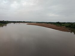
 Andhari river near
Mul,
Maharashtra | |
| Location | |
| Country | India |
| State | Maharashtra |
| Region | Vidarbha |
| District | Chandrapur |
| Physical characteristics | |
| Source | |
| • location | Chandrapur |
| Mouth | Wainganga river |
• location | Near Ghatkul village, Chandrapur |
• coordinates | 19°44′29″N 79°45′59″E / 19.74139°N 79.76639°E |
Andhari river is a minor river of the Wainganga basin. It flows through the Chandrapur district of Maharashtra. Meandering through the Tadoba forests, it gives its name to Tadoba Andhari Tiger Reserve. [1]
References
- ^ "Central Provinces District Gazetteers - Chanda". Gazetteers.maharashtra.gov.in. Retrieved 15 August 2022.
This article relies largely or entirely on a
single source. (August 2022) |
| Andhari River | |
|---|---|
 Andhari river near
Mul,
Maharashtra | |
| Location | |
| Country | India |
| State | Maharashtra |
| Region | Vidarbha |
| District | Chandrapur |
| Physical characteristics | |
| Source | |
| • location | Chandrapur |
| Mouth | Wainganga river |
• location | Near Ghatkul village, Chandrapur |
• coordinates | 19°44′29″N 79°45′59″E / 19.74139°N 79.76639°E |
Andhari river is a minor river of the Wainganga basin. It flows through the Chandrapur district of Maharashtra. Meandering through the Tadoba forests, it gives its name to Tadoba Andhari Tiger Reserve. [1]
References
- ^ "Central Provinces District Gazetteers - Chanda". Gazetteers.maharashtra.gov.in. Retrieved 15 August 2022.