Aminadav
עַמִּינָדָב عميناداف / عميناداڤ | |
|---|---|
| Hebrew transcription(s) | |
| • official | Amminadav |
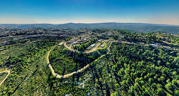
 Aminadav forest | |
| Etymology: Named after Amminadab | |
| Coordinates: 31°45′5″N 35°8′33″E / 31.75139°N 35.14250°E | |
| Country | Israel |
| District | Jerusalem |
| Council | Mateh Yehuda |
| Affiliation | Moshavim Movement |
| Founded | 1950 |
| Founded by | Yemenite Jews |
| Population (2022)
[1] | 1,119 |
Aminadav ( Hebrew: עַמִּינָדָב) is a moshav in central Israel. Located southwest of Jerusalem near Yad Kennedy, it falls under the jurisdiction of Mateh Yehuda Regional Council. In 2022 it had a population of 1,119. [1]

The name "Aminadav" is a combination of two Hebrew words; "Ami"- my nation, and "Nadav"- generous, giving, or volunteering; thus Aminadav translates "a generous people" and the moshav is named after biblical Aminadav [2](Exodus 6:23 et al.); "Nachshon ben Aminadav" was the first man to enter the "Red Sea" as the Jews left slavery in Egypt.[ citation needed]
The village was established in 1950 by Yemeni Jews. Between 1952 and 1953 it absorbed more immigrants from North Africa as well as some native Israelis.[ citation needed]
Aminadav was located on land that had belonged to the Palestinian village of al-Walaja. [3]
The Aminadav Forest, spread over 7 km2 (700 ha), is a combination of natural woodland and trees planted by the Jewish National Fund along the Salmon- Sorek contour. The forest overlooks the Sorek and Refa`im riverbeds and the Jerusalem hills. In the forest are several natural springs, ancient agricultural terraces, orchards, ancient wine presses and chalk pits. [4] The Lord Sacks forest is a forest of 25,000 trees being planted within the Aminadav forest by the JNF, UK. It is named for Chief Rabbi of the United Hebrew Congregations of the Commonwealth, Lord Jonathan Sacks. [5]
- ^ a b "Regional Statistics". Israel Central Bureau of Statistics. Retrieved 21 March 2024.
- ^ Carta's Official Guide to Israel and Complete Gazetteer to all Sites in the Holy Land. (3rd edition 1993) Jerusalem, Carta, p. 77, ISBN 965-220-186-3
- ^ Khalidi, W. (1992). All That Remains: The Palestinian Villages Occupied and Depopulated by Israel in 1948. Washington D.C.: Institute for Palestine Studies. p. 323. ISBN 0-88728-224-5.
- ^ "Aminadav forest". My-country-israel.com. Archived from the original on 2011-11-19. Retrieved 2013-08-11.
- ^ JNF Lord Sacks forest Archived May 16, 2011, at the Wayback Machine
Aminadav
עַמִּינָדָב عميناداف / عميناداڤ | |
|---|---|
| Hebrew transcription(s) | |
| • official | Amminadav |
 Aminadav forest | |
| Etymology: Named after Amminadab | |
| Coordinates: 31°45′5″N 35°8′33″E / 31.75139°N 35.14250°E | |
| Country | Israel |
| District | Jerusalem |
| Council | Mateh Yehuda |
| Affiliation | Moshavim Movement |
| Founded | 1950 |
| Founded by | Yemenite Jews |
| Population (2022)
[1] | 1,119 |
Aminadav ( Hebrew: עַמִּינָדָב) is a moshav in central Israel. Located southwest of Jerusalem near Yad Kennedy, it falls under the jurisdiction of Mateh Yehuda Regional Council. In 2022 it had a population of 1,119. [1]

The name "Aminadav" is a combination of two Hebrew words; "Ami"- my nation, and "Nadav"- generous, giving, or volunteering; thus Aminadav translates "a generous people" and the moshav is named after biblical Aminadav [2](Exodus 6:23 et al.); "Nachshon ben Aminadav" was the first man to enter the "Red Sea" as the Jews left slavery in Egypt.[ citation needed]
The village was established in 1950 by Yemeni Jews. Between 1952 and 1953 it absorbed more immigrants from North Africa as well as some native Israelis.[ citation needed]
Aminadav was located on land that had belonged to the Palestinian village of al-Walaja. [3]
The Aminadav Forest, spread over 7 km2 (700 ha), is a combination of natural woodland and trees planted by the Jewish National Fund along the Salmon- Sorek contour. The forest overlooks the Sorek and Refa`im riverbeds and the Jerusalem hills. In the forest are several natural springs, ancient agricultural terraces, orchards, ancient wine presses and chalk pits. [4] The Lord Sacks forest is a forest of 25,000 trees being planted within the Aminadav forest by the JNF, UK. It is named for Chief Rabbi of the United Hebrew Congregations of the Commonwealth, Lord Jonathan Sacks. [5]
- ^ a b "Regional Statistics". Israel Central Bureau of Statistics. Retrieved 21 March 2024.
- ^ Carta's Official Guide to Israel and Complete Gazetteer to all Sites in the Holy Land. (3rd edition 1993) Jerusalem, Carta, p. 77, ISBN 965-220-186-3
- ^ Khalidi, W. (1992). All That Remains: The Palestinian Villages Occupied and Depopulated by Israel in 1948. Washington D.C.: Institute for Palestine Studies. p. 323. ISBN 0-88728-224-5.
- ^ "Aminadav forest". My-country-israel.com. Archived from the original on 2011-11-19. Retrieved 2013-08-11.
- ^ JNF Lord Sacks forest Archived May 16, 2011, at the Wayback Machine
