Ambatolampy | |
|---|---|
 Ambatolampy skyline | |
 Map of Antananarivo Province showing the location of Ambatolampy | |
 Ambatolampy Location in Madagascar | |
| Coordinates: 19°23′10″S 47°25′45″E / 19.38611°S 47.42917°E | |
| Country | |
| Region | Vakinankaratra |
| Area | |
| • Total | 30 km2 (10 sq mi) |
| Elevation | 1,644 m (5,394 ft) |
| Population (2013) | |
| • Total | 28,500 |
| Postal code | 104 |
| Climate | Cwb |

Ambatolampy is a city (commune urbaine) in the Vakinankaratra Region, situated in the Central Highlands of Madagascar. It had a population of about 28,500 in 2013. [1]
It is the administrative capital of the district of the same name, and is situated on Route nationale No. 7 which runs from Antananarivo to Toliara. Ambatolampy is a railway station on the Antananarivo - Antsirabe line. It is situated at 70 km South from the capital Antananarivo.
A species of gecko, Lygodactylus tolampyae, may be named after Ambatolampy. [2]
Economy
Ambatolampy is known for its Aluminium founderies. Most of aluminium kitchen utensils in Madagascar are produced in this town. The founderies also work with copper and bronze. [3] Various workshops are specialized in recycling old metal.
Museums
The Butterfly museum (Musée des Papillons) is in Ambatolampy. [4] The museum exhibits 6,000 species of insects and butterflies.
-
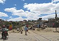 Railway crossing
 -
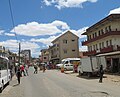 Main Street
 -
 Main street
 -
 Oxcarts
 -
 Recycling metal in a foundery
 -
 Typical residential area


See also
External links
-
 Media related to
Ambatolampy at Wikimedia Commons
Media related to
Ambatolampy at Wikimedia Commons
References
- ^ Institut National de la Statistique, Antananarivo.
- ^ Beolens, Bo; Watkins, Michael; Grayson, Michael (2011). The Eponym Dictionary of Reptiles. Baltimore: Johns Hopkins University Press. xiii + 296 pp. ISBN 978-1-4214-0135-5. ("Tolampy", p. 266).
- ^ jacaranda.fr
- ^ Madacamp
Capital:
Antsirabe | ||
| Ambatolampy (19) |  | |
| Antanifotsy (14) | ||
| Antsirabe I (1) | ||
| Antsirabe II (20) | ||
| Betafo (18) | ||
| Faratsiho (9) | ||
| Mandoto (9) | ||
7 districts; 89 communes | ||
|
| This Vakinankaratra location article is a stub. You can help Wikipedia by expanding it. |
Ambatolampy | |
|---|---|
|
Ambatolampy skyline | |
|
Map of Antananarivo Province showing the location of Ambatolampy | |
Ambatolampy Location in Madagascar | |
| Coordinates: 19°23′10″S 47°25′45″E / 19.38611°S 47.42917°E | |
| Country | |
| Region | Vakinankaratra |
| Area | |
| • Total | 30 km2 (10 sq mi) |
| Elevation | 1,644 m (5,394 ft) |
| Population (2013) | |
| • Total | 28,500 |
| Postal code | 104 |
| Climate | Cwb |
Ambatolampy is a city (commune urbaine) in the Vakinankaratra Region, situated in the Central Highlands of Madagascar. It had a population of about 28,500 in 2013. [1]
It is the administrative capital of the district of the same name, and is situated on Route nationale No. 7 which runs from Antananarivo to Toliara. Ambatolampy is a railway station on the Antananarivo - Antsirabe line. It is situated at 70 km South from the capital Antananarivo.
A species of gecko, Lygodactylus tolampyae, may be named after Ambatolampy. [2]
Economy
Ambatolampy is known for its Aluminium founderies. Most of aluminium kitchen utensils in Madagascar are produced in this town. The founderies also work with copper and bronze. [3] Various workshops are specialized in recycling old metal.
Museums
The Butterfly museum (Musée des Papillons) is in Ambatolampy. [4] The museum exhibits 6,000 species of insects and butterflies.
-
Railway crossing
-
Main Street
-
Main street
-
Oxcarts
-
Recycling metal in a foundery
-
Typical residential area
See also
External links
-
Media related to
Ambatolampy at Wikimedia Commons
References
- ^ Institut National de la Statistique, Antananarivo.
- ^ Beolens, Bo; Watkins, Michael; Grayson, Michael (2011). The Eponym Dictionary of Reptiles. Baltimore: Johns Hopkins University Press. xiii + 296 pp. ISBN 978-1-4214-0135-5. ("Tolampy", p. 266).
- ^ jacaranda.fr
- ^ Madacamp
Capital:
Antsirabe | ||
| Ambatolampy (19) | | |
| Antanifotsy (14) | ||
| Antsirabe I (1) | ||
| Antsirabe II (20) | ||
| Betafo (18) | ||
| Faratsiho (9) | ||
| Mandoto (9) | ||
7 districts; 89 communes | ||
|
| This Vakinankaratra location article is a stub. You can help Wikipedia by expanding it. |