Photos • Location

Municipalities bordering Cauca; boundary intersections indicated in red.
Almaguer | |
|---|---|
Municipality and town | |
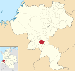
 Location of the municipality and town of Almaguer in the Cauca Department of Colombia. | |
| Coordinates: 1°55′N 76°52′W / 1.917°N 76.867°W | |
| Country | |
| Department | Cauca Department |
| Population (Census 2018
[1]) | |
| • Total | 16,523 |
| Time zone | UTC-5 (Colombia Standard Time) |
| Climate | Cfb |
Almaguer (Spanish pronunciation: [almaˈɣeɾ]) is a town and municipality in the Cauca Department, Colombia.
Founded in 1551 by Vasco de Guzmán and Alonso de Fuenmayor, the municipality covers an area of 520 km2 and has a population of 21,300. [2] The population is primarily engaged in agriculture.

Notable residents
References
- ^ "Censo Nacional de Población y Vivienda 2018" (in Spanish). DANE. Retrieved 23 April 2020.
- ^ "Departemento del Cauca". Fundefilms. Archived from the original on November 23, 2008. Retrieved March 29, 2009.
1°55′N 76°52′W / 1.917°N 76.867°W
Almaguer | |
|---|---|
Municipality and town | |
 Location of the municipality and town of Almaguer in the Cauca Department of Colombia. | |
| Coordinates: 1°55′N 76°52′W / 1.917°N 76.867°W | |
| Country | |
| Department | Cauca Department |
| Population (Census 2018
[1]) | |
| • Total | 16,523 |
| Time zone | UTC-5 (Colombia Standard Time) |
| Climate | Cfb |
Almaguer (Spanish pronunciation: [almaˈɣeɾ]) is a town and municipality in the Cauca Department, Colombia.
Founded in 1551 by Vasco de Guzmán and Alonso de Fuenmayor, the municipality covers an area of 520 km2 and has a population of 21,300. [2] The population is primarily engaged in agriculture.

Notable residents
References
- ^ "Censo Nacional de Población y Vivienda 2018" (in Spanish). DANE. Retrieved 23 April 2020.
- ^ "Departemento del Cauca". Fundefilms. Archived from the original on November 23, 2008. Retrieved March 29, 2009.
1°55′N 76°52′W / 1.917°N 76.867°W


