Photos • Location
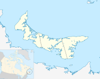
Location of Alma in
Prince Edward Island
46°51′40″N 64°06′32″W / 46.861°N 64.109°W Alma is a settlement in Prince Edward Island.
It is an unincorporated area located in Prince County in the western portion of Prince Edward Island, northwest of Alberton. Its precise location is N 46°52', W 64°07'.
Location of Alma in
Prince Edward Island
46°51′40″N 64°06′32″W / 46.861°N 64.109°W Alma is a settlement in Prince Edward Island.
It is an unincorporated area located in Prince County in the western portion of Prince Edward Island, northwest of Alberton. Its precise location is N 46°52', W 64°07'.
