Alfter | |
|---|---|
![Schloss Alfter [de] in Alfter](/info/en/?search=File:Alfter_Schloss_(03).png)
Schloss Alfter in Alfter | |
 Coat of arms | |
Location of Alfter within Rhein-Sieg-Kreis district 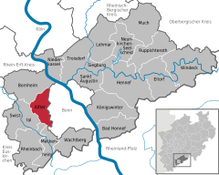 | |
 Alfter  Alfter | |
| Coordinates: 50°44′08″N 07°00′33″E / 50.73556°N 7.00917°E | |
| Country | Germany |
| State | North Rhine-Westphalia |
| Admin. region | Köln |
| District | Rhein-Sieg-Kreis |
| Government | |
| • Mayor (2020–25) | Rolf Schumacher [1] ( CDU) |
| Area | |
| • Total | 34.73 km2 (13.41 sq mi) |
| Elevation | 76 m (249 ft) |
| Population (2022-12-31)
[2] | |
| • Total | 23,904 |
| • Density | 690/km2 (1,800/sq mi) |
| Time zone | UTC+01:00 ( CET) |
| • Summer ( DST) | UTC+02:00 ( CEST) |
| Postal codes | 53347 |
| Dialling codes | 02222, 0228 |
| Vehicle registration | SU |
| Website | www.alfter.de |
Alfter ( Kölsch: Alefte) is a municipality in the Rhein-Sieg district, in North Rhine-Westphalia, Germany. It is situated approximately 6 km west of Bonn.
Location
The community of Alfter lies west of former capital of Bonn, on the southern ridge of the "Vorgebirge". It borders on the city of Bornheim to the north, Bonn to the east, the cities of Meckenheim and Rheinbach to the south and the community of Swisttal to the west. Alfter consists of a total area of 35 km², of which 18 km² is used for agricultural purposes and 8 km² is forest.
References
- ^ Wahlergebnisse in NRW Kommunalwahlen 2020, Land Nordrhein-Westfalen, accessed 29 June 2021.
- ^ "Bevölkerung der Gemeinden Nordrhein-Westfalens am 31. Dezember 2022 – Fortschreibung des Bevölkerungsstandes auf Basis des Zensus vom 9. Mai 2011" (in German). Landesbetrieb Information und Technik NRW. Retrieved 20 June 2023.
Towns and municipalities in
Rhein-Sieg-Kreis | ||
|---|---|---|
| International | |
|---|---|
| National | |
|
| This Rhein-Sieg-Kreis location article is a stub. You can help Wikipedia by expanding it. |
Alfter | |
|---|---|
|
Schloss Alfter in Alfter | |
|
Coat of arms | |
Location of Alfter within Rhein-Sieg-Kreis district | |
Alfter Alfter | |
| Coordinates: 50°44′08″N 07°00′33″E / 50.73556°N 7.00917°E | |
| Country | Germany |
| State | North Rhine-Westphalia |
| Admin. region | Köln |
| District | Rhein-Sieg-Kreis |
| Government | |
| • Mayor (2020–25) | Rolf Schumacher [1] ( CDU) |
| Area | |
| • Total | 34.73 km2 (13.41 sq mi) |
| Elevation | 76 m (249 ft) |
| Population (2022-12-31)
[2] | |
| • Total | 23,904 |
| • Density | 690/km2 (1,800/sq mi) |
| Time zone | UTC+01:00 ( CET) |
| • Summer ( DST) | UTC+02:00 ( CEST) |
| Postal codes | 53347 |
| Dialling codes | 02222, 0228 |
| Vehicle registration | SU |
| Website | www.alfter.de |
Alfter ( Kölsch: Alefte) is a municipality in the Rhein-Sieg district, in North Rhine-Westphalia, Germany. It is situated approximately 6 km west of Bonn.
Location
The community of Alfter lies west of former capital of Bonn, on the southern ridge of the "Vorgebirge". It borders on the city of Bornheim to the north, Bonn to the east, the cities of Meckenheim and Rheinbach to the south and the community of Swisttal to the west. Alfter consists of a total area of 35 km², of which 18 km² is used for agricultural purposes and 8 km² is forest.
References
- ^ Wahlergebnisse in NRW Kommunalwahlen 2020, Land Nordrhein-Westfalen, accessed 29 June 2021.
- ^ "Bevölkerung der Gemeinden Nordrhein-Westfalens am 31. Dezember 2022 – Fortschreibung des Bevölkerungsstandes auf Basis des Zensus vom 9. Mai 2011" (in German). Landesbetrieb Information und Technik NRW. Retrieved 20 June 2023.
Towns and municipalities in
Rhein-Sieg-Kreis | ||
|---|---|---|
| International | |
|---|---|
| National | |
|
| This Rhein-Sieg-Kreis location article is a stub. You can help Wikipedia by expanding it. |