Photos • Location
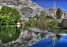
View of Alcalá del Jucar with
Church of San Andrés on right.


Alcalá del Júcar | |
|---|---|
municipality | |
 Seal | |
| Country | Spain |
| Autonomous community | Castile-La Mancha |
| Province | Albacete |
| Comarca | Manchuela |
| Area | |
| • Total | 146.82 km2 (56.69 sq mi) |
| Elevation | 596 m (1,955 ft) |
| Population (2018)
[1] | |
| • Total | 1,199 |
| • Density | 8.2/km2 (21/sq mi) |
| Time zone | UTC+1 ( CET) |
| • Summer ( DST) | UTC+2 ( CEST) |

Alcalá del Júcar is a municipality in Province of Albacete, Castile-La Mancha, Spain. It has a population of 1,442.
- ^ Municipal Register of Spain 2018. National Statistics Institute.
Wikimedia Commons has media related to
Alcalá del Júcar.
- Alcalá del Júcar Town hall
- Alcalá del Júcar - Web de la Diputación
- Alcalá del Júcar - Useful, but no official, website of the village
39°12′N 1°26′W / 39.200°N 1.433°W
|
| This Albacete Province location article is a stub. You can help Wikipedia by expanding it. |
Alcalá del Júcar | |
|---|---|
municipality | |
|
Seal | |
| Country | Spain |
| Autonomous community | Castile-La Mancha |
| Province | Albacete |
| Comarca | Manchuela |
| Area | |
| • Total | 146.82 km2 (56.69 sq mi) |
| Elevation | 596 m (1,955 ft) |
| Population (2018)
[1] | |
| • Total | 1,199 |
| • Density | 8.2/km2 (21/sq mi) |
| Time zone | UTC+1 ( CET) |
| • Summer ( DST) | UTC+2 ( CEST) |
Alcalá del Júcar is a municipality in Province of Albacete, Castile-La Mancha, Spain. It has a population of 1,442.
- ^ Municipal Register of Spain 2018. National Statistics Institute.
Wikimedia Commons has media related to
Alcalá del Júcar.
- Alcalá del Júcar Town hall
- Alcalá del Júcar - Web de la Diputación
- Alcalá del Júcar - Useful, but no official, website of the village
39°12′N 1°26′W / 39.200°N 1.433°W
|
| This Albacete Province location article is a stub. You can help Wikipedia by expanding it. |