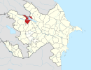
40°46′N 46°24′E / 40.767°N 46.400°E
Alıncalı | |
|---|---|
| Coordinates: 40°46′N 46°24′E / 40.767°N 46.400°E | |
| Country | |
| Rayon | Samukh |
| Time zone | UTC+4 ( AZT) |
| • Summer ( DST) | UTC+5 ( AZT) |
Alıncalı (also, Alyndzhaly) is a village in the Samukh Rayon of Azerbaijan.
There are 8 airports near Alıncalı, of which two are larger airports. The closest airport in Azerbaijan is Ganja Airport in a distance of 4 mi (or 6 km), South-West.[ citation needed]
There are several Unesco world heritage sites nearby. The closest heritage site is Monasteries of Haghpat and Sanahin in Armenia at a distance of 90 mi (or 145 km).[ citation needed]

