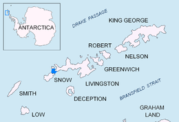
 Location of Morton Strait in the South Shetland Islands. | |
| Geography | |
|---|---|
| Location | Antarctica |
| Coordinates | 62°41′43.6″S 61°15′50.6″W / 62.695444°S 61.264056°W |
| Administration | |
| Administered under the Antarctic Treaty System | |
| Demographics | |
| Population | Uninhabited |
Aim Rocks is a group of rocks lying east of Cape Timblón in the middle of Morton Strait in the South Shetland Islands, Antarctica. The name, given by the United Kingdom Antarctic Place-Names Committee in 1961, is descriptive; these rocks in line are a guide for safe passage through the southern entrance of Morton Strait.
See also
Maps
- L.L. Ivanov et al. Antarctica: Livingston Island and Greenwich Island, South Shetland Islands. Scale 1:100000 topographic map. Sofia: Antarctic Place-names Commission of Bulgaria, 2005.
- L.L. Ivanov. Antarctica: Livingston Island and Greenwich, Robert, Snow and Smith Islands. Scale 1:120000 topographic map. Troyan: Manfred Wörner Foundation, 2009. ISBN 978-954-92032-6-4
References
![]() This article incorporates
public domain material from
"Aim Rocks".
Geographic Names Information System.
United States Geological Survey.
This article incorporates
public domain material from
"Aim Rocks".
Geographic Names Information System.
United States Geological Survey.


