Aghitu
Աղիտու | |
|---|---|
 Aghitu in 2013 | |
 Aghitu  Aghitu | |
| Coordinates: 39°30′55″N 46°04′51″E / 39.51528°N 46.08083°E | |
| Country | Armenia |
| Province | Syunik |
| Municipality | Sisian |
| Area | |
| • Total | 19.44 km2 (7.51 sq mi) |
| Population | |
| • Total | 436 |
| • Density | 22/km2 (58/sq mi) |
| Time zone | UTC+4 ( AMT) |
| Aghitu at GEOnet Names Server | |
Aghitu ( Armenian: Աղիտու) is a village in the Sisian Municipality of the Syunik Province in Armenia. It is located on the left bank of the Vorotan river, 7 kilometers east of the regional capital of Sisian. [3]
History
In the 2nd to 1st millennium BC, the territory of Aghitu was one of the southern strongholds of the Etiuni confederation in Armenia, with the archaeological ruins of a fortress from that time period located in the village. [4]
Mausoleum of Aghitu

The village is famous for the 6th-7th century Aghitu mausoleum and funerary complex. [5] [6] Two rectangular towers rise above the mausoleum with a richly decorated octagonal column in the center. The monument is decorated with carvings of pomegranates, grapes, vegetables, and geometric ornaments similar to the 7th century churches of Sisian and Zvartnots. [6] [3] According to tradition, the mausoleum was in honor of three Armenian princes of Syunik who fought off Persian solidiers. The Persians and Armenians fought a decisive battle near a village called Aghudi where they were able to drive out the Persians. However, that battle took the lives of the three princes. In their honor, the residents of the village buried the princes and built a crypt and monument for them. [5] [6] The monument was damaged in the earthquake of 1931 however it was restored promptly by the Armenian authorities. [3]
Demographics
The Statistical Committee of Armenia reported its population as 304 in 2010, [7] up from 209 at the 2001 census. [8] Prior to 1988, the village was partly inhabited by Azerbaijanis who settled there from Nakhchivan, Iran, and other localities. [6]
Gallery
-
 Scenery
 -
 Aghitu monument
 -
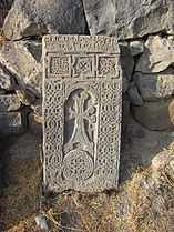 Khachkar in Aghitu
 -
 Scenery


References
- ^ "Syunik regional e-Governance System" (in Armenian). Syunik Province provincial government. Click on link entitled "Համայնքներ" (community) and search for the place by Armenian name.
- ^ Statistical Committee of Armenia. "The results of the 2011 Population Census of Armenia" (PDF).
- ^ a b c Gasparyan, Mnatsakanyan & Karakhanyan 1974, p. 266.
- ^ Avetisyan et al. 2019, p. 9.
- ^ a b Dum-Tragut 2023, p. 452.
- ^ a b c d Hakobyan, Melik-Bakhshyan & Barseghyan 1986, p. 200.
- ^ "Marzes of Armenia and Yerevan City in Figures, 2010" (PDF). Statistical Committee of Armenia.
- ^ Report of the results of the 2001 Armenian Census, Statistical Committee of Armenia
Bibliography
- Avetisyan, Hayk; Gnuni, Artak; Sargsyan, Gagik; Bobokhyan, Arsen (2019). "Human Images from the Eastern Urartian Periphery: Anthropomorphic Sculpture of Syunik on the Cusp of the 2nd and 1st Millennia BC". In Avetisyan, Pavel S.; Dan, Roberto; Grekyan, Yervand H. (eds.). Over the Mountains and Far Away: Studies in Near Eastern history and archaeology. Archaeopress. pp. 9–18. ISBN 9781784919443.
- Gasparyan, B.; Mnatsakanyan, S.; Karakhanyan, G. (1974). "ԱՂՈՒԴԻ [Aghudi]". In Ambartsumian, Viktor (ed.). Armenian Soviet Encyclopedia (in Armenian). Vol. 1. Yerevan: Academy of Sciences of the Armenian SSR. p. 266. OCLC 22420067.
- Dum-Tragut, Jasmine (2023). "Aghitu". Armenien: 3000 Jahre Kultur zwischen Ost und West. Mit Jerevan, Edschmiatsin, Sevansee, Dilidschan, Gjumri, Vandzor und Goris [Armenia: 3000 years of culture between East and West. With Yerevan, Edzmiatsin, Lake Sevan, Dilijan, Gyumri, Vandzor and Goris] (in German). Germany: Trescher Verlag. p. 452. ISBN 9783897946248.
- Hakobyan, Tadevos Kh.; Melik-Bakhshyan, Stepan T.; Barseghyan, Hovhannes Kh. (1986). "Աղուդի [Aghitu]". Հայաստանի եւ հարակից շրջանների տեղանունների բառարան [Dictionary of place names of Armenia and neighboring regions]. Vol. 1. Yerevan: Yerevan State University Press. p. 200.

|
| This article about a location in Syunik Province, Armenia is a stub. You can help Wikipedia by expanding it. |
Aghitu
Աղիտու | |
|---|---|
|
Aghitu in 2013 | |
Aghitu Aghitu | |
| Coordinates: 39°30′55″N 46°04′51″E / 39.51528°N 46.08083°E | |
| Country | Armenia |
| Province | Syunik |
| Municipality | Sisian |
| Area | |
| • Total | 19.44 km2 (7.51 sq mi) |
| Population | |
| • Total | 436 |
| • Density | 22/km2 (58/sq mi) |
| Time zone | UTC+4 ( AMT) |
| Aghitu at GEOnet Names Server | |
Aghitu ( Armenian: Աղիտու) is a village in the Sisian Municipality of the Syunik Province in Armenia. It is located on the left bank of the Vorotan river, 7 kilometers east of the regional capital of Sisian. [3]
History
In the 2nd to 1st millennium BC, the territory of Aghitu was one of the southern strongholds of the Etiuni confederation in Armenia, with the archaeological ruins of a fortress from that time period located in the village. [4]
Mausoleum of Aghitu
The village is famous for the 6th-7th century Aghitu mausoleum and funerary complex. [5] [6] Two rectangular towers rise above the mausoleum with a richly decorated octagonal column in the center. The monument is decorated with carvings of pomegranates, grapes, vegetables, and geometric ornaments similar to the 7th century churches of Sisian and Zvartnots. [6] [3] According to tradition, the mausoleum was in honor of three Armenian princes of Syunik who fought off Persian solidiers. The Persians and Armenians fought a decisive battle near a village called Aghudi where they were able to drive out the Persians. However, that battle took the lives of the three princes. In their honor, the residents of the village buried the princes and built a crypt and monument for them. [5] [6] The monument was damaged in the earthquake of 1931 however it was restored promptly by the Armenian authorities. [3]
Demographics
The Statistical Committee of Armenia reported its population as 304 in 2010, [7] up from 209 at the 2001 census. [8] Prior to 1988, the village was partly inhabited by Azerbaijanis who settled there from Nakhchivan, Iran, and other localities. [6]
Gallery
-
Scenery
-
Aghitu monument
-
Khachkar in Aghitu
-
Scenery
References
- ^ "Syunik regional e-Governance System" (in Armenian). Syunik Province provincial government. Click on link entitled "Համայնքներ" (community) and search for the place by Armenian name.
- ^ Statistical Committee of Armenia. "The results of the 2011 Population Census of Armenia" (PDF).
- ^ a b c Gasparyan, Mnatsakanyan & Karakhanyan 1974, p. 266.
- ^ Avetisyan et al. 2019, p. 9.
- ^ a b Dum-Tragut 2023, p. 452.
- ^ a b c d Hakobyan, Melik-Bakhshyan & Barseghyan 1986, p. 200.
- ^ "Marzes of Armenia and Yerevan City in Figures, 2010" (PDF). Statistical Committee of Armenia.
- ^ Report of the results of the 2001 Armenian Census, Statistical Committee of Armenia
Bibliography
- Avetisyan, Hayk; Gnuni, Artak; Sargsyan, Gagik; Bobokhyan, Arsen (2019). "Human Images from the Eastern Urartian Periphery: Anthropomorphic Sculpture of Syunik on the Cusp of the 2nd and 1st Millennia BC". In Avetisyan, Pavel S.; Dan, Roberto; Grekyan, Yervand H. (eds.). Over the Mountains and Far Away: Studies in Near Eastern history and archaeology. Archaeopress. pp. 9–18. ISBN 9781784919443.
- Gasparyan, B.; Mnatsakanyan, S.; Karakhanyan, G. (1974). "ԱՂՈՒԴԻ [Aghudi]". In Ambartsumian, Viktor (ed.). Armenian Soviet Encyclopedia (in Armenian). Vol. 1. Yerevan: Academy of Sciences of the Armenian SSR. p. 266. OCLC 22420067.
- Dum-Tragut, Jasmine (2023). "Aghitu". Armenien: 3000 Jahre Kultur zwischen Ost und West. Mit Jerevan, Edschmiatsin, Sevansee, Dilidschan, Gjumri, Vandzor und Goris [Armenia: 3000 years of culture between East and West. With Yerevan, Edzmiatsin, Lake Sevan, Dilijan, Gyumri, Vandzor and Goris] (in German). Germany: Trescher Verlag. p. 452. ISBN 9783897946248.
- Hakobyan, Tadevos Kh.; Melik-Bakhshyan, Stepan T.; Barseghyan, Hovhannes Kh. (1986). "Աղուդի [Aghitu]". Հայաստանի եւ հարակից շրջանների տեղանունների բառարան [Dictionary of place names of Armenia and neighboring regions]. Vol. 1. Yerevan: Yerevan State University Press. p. 200.
|
| This article about a location in Syunik Province, Armenia is a stub. You can help Wikipedia by expanding it. |