Native name: Adi Jaya | |
|---|---|
 Pulau Adi Location in Papua  Pulau Adi Location in Indonesia | |
| Geography | |
| Coordinates | 4°12′54.654″S 133°28′0.807″E / 4.21518167°S 133.46689083°E |
| Area | 157.9 km2 (61.0 sq mi) [1] |
| Length | 44 km (27.3 mi) [2] |
| Width | 7 km (4.3 mi) [2] |
| Coastline | 100 km (60 mi) |
| Highest elevation | 200 m (700 ft) [1] |
| Administration | |
Indonesia | |
| Province | West Papua |
| Regency | Kaimana |
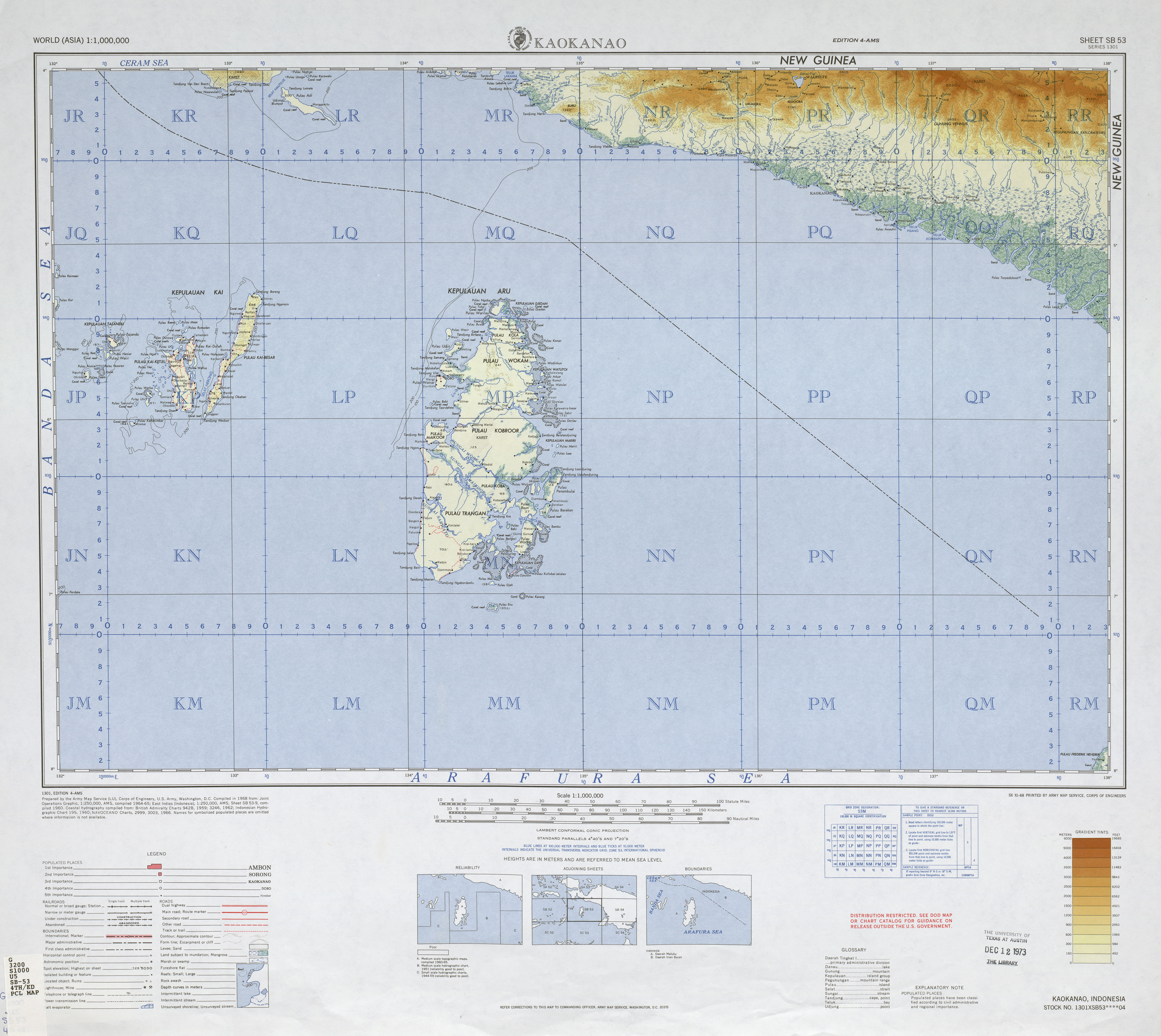
Adi (or Adi Island, Indonesian: Pulau Adi) is an Indonesian island.
Adi is located approximately 450 kilometres (280 mi) south of the equator in the Seram Sea off the western coast of New Guinea. It is severed from the Bomberai Peninsula by Nautilus Strait, the narrowest width of which is only ten kilometres (6.2 mi). Adi marks the southern border of the Kamrau Bay; beyond lies the open Seram Sea. [3] [4]
References
- ^ a b "UNEP Islands Directory". Archived from the original on 2012-12-06.
- ^ a b "International Map of the World, Blatt SB-53". Retrieved 2010-06-18.
- ^ "National Geographic Adi Island".
- ^ http://www.ppk-kp3k.kkp.go.id/direktori-pulau/index.php/public_c/pulau_info/13475
Native name: Adi Jaya | |
|---|---|
Pulau Adi Location in Papua Pulau Adi Location in Indonesia | |
| Geography | |
| Coordinates | 4°12′54.654″S 133°28′0.807″E / 4.21518167°S 133.46689083°E |
| Area | 157.9 km2 (61.0 sq mi) [1] |
| Length | 44 km (27.3 mi) [2] |
| Width | 7 km (4.3 mi) [2] |
| Coastline | 100 km (60 mi) |
| Highest elevation | 200 m (700 ft) [1] |
| Administration | |
Indonesia | |
| Province | West Papua |
| Regency | Kaimana |
Adi (or Adi Island, Indonesian: Pulau Adi) is an Indonesian island.
Adi is located approximately 450 kilometres (280 mi) south of the equator in the Seram Sea off the western coast of New Guinea. It is severed from the Bomberai Peninsula by Nautilus Strait, the narrowest width of which is only ten kilometres (6.2 mi). Adi marks the southern border of the Kamrau Bay; beyond lies the open Seram Sea. [3] [4]
References
- ^ a b "UNEP Islands Directory". Archived from the original on 2012-12-06.
- ^ a b "International Map of the World, Blatt SB-53". Retrieved 2010-06-18.
- ^ "National Geographic Adi Island".
- ^ http://www.ppk-kp3k.kkp.go.id/direktori-pulau/index.php/public_c/pulau_info/13475