| Academia Peak | |
|---|---|
 | |
| Highest point | |
| Elevation | 1,253 m (4,111 ft) |
| Coordinates | 62°40′13″S 60°12′30″W / 62.67028°S 60.20833°W |
| Geography | |
 Academia Peak | |
| Parent range | Tangra Mountains |
| Climbing | |
| First ascent | 16 January 2017 Doychin Boyanov, Nikolay Petkov and Nedelcho Hazarbasanov |
Academia Peak ( Bulgarian: връх Академия, romanized: vrah Akademiya, IPA: [ˈvrɤx ɐkɐˈdɛmijɐ]) is a peak rising to 1,253 m in the Friesland Ridge, Tangra Mountains on eastern Livingston Island in Antarctica. The peak has precipitous and ice-free north-western slopes and surmounts Huntress Glacier to the northwest and southwest. It was first ascended and GPS-surveyed by the Bulgarian climbers D. Boyanov, N. Petkov and N. Hazarbasanov from Nesebar Gap via the head of Huntress Glacier on 15 January 2017. [1]
The peak is named for the Bulgarian Academy of Sciences (established 1869) for its important role in the Bulgarian Antarctic research.
Location
The peak is located 1 km northwest of St. Boris Peak, 2.96 km south by southeast of the summit of Pliska Ridge and 3.9 km east by southeast of Willan Nunatak. The peak was first mapped by Bulgaria in 2005, and later in 2009.
See also
Maps
- L.L. Ivanov et al. Antarctica: Livingston Island and Greenwich Island, South Shetland Islands. Scale 1:100000 topographic map. Sofia: Antarctic Place-names Commission of Bulgaria, 2005.
- L.L. Ivanov. Antarctica: Livingston Island and Greenwich, Robert, Snow and Smith Islands. Scale 1:120000 topographic map. Troyan: Manfred Wörner Foundation, 2009.
- Antarctic Digital Database (ADD). Scale 1:250000 topographic map of Antarctica. Scientific Committee on Antarctic Research (SCAR). Since 1993, regularly upgraded and updated.
- L.L. Ivanov. Antarctica: Livingston Island and Smith Island. Scale 1:100000 topographic map. Manfred Wörner Foundation, 2017. ISBN 978-619-90008-3-0
- A. Kamburov and L. Ivanov. Bowles Ridge and Central Tangra Mountains: Livingston Island, Antarctica. Scale 1:25000 map. Sofia: Manfred Wörner Foundation, 2023. ISBN 978-619-90008-6-1
Gallery
-
 Topographic map of Livingston Island and Smith Island
 -
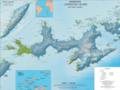
 Location of Tangra Mountains on Livingston Island in the South Shetland Islands
 -
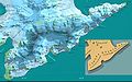 Map of Tangra Mountains
 -
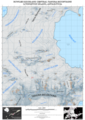 Topographic map of Bowles Ridge and central Tangra Mountains featuring Academia Peak


Notes
- ^ D. Boyanov and N. Petkov. The Peaks of Tangra Mountains: Project Report Part Two 2016/17. Sofia, February 2017 (in Bulgarian)
References
- Academia Peak. SCAR Composite Gazetteer of Antarctica
- Reference Map
- Bulgarian Antarctic Gazetteer. Antarctic Place-names Commission. (details in Bulgarian, basic data in English)
External links
- Academia Peak. Copernix satellite image
This article includes information from the Antarctic Place-names Commission of Bulgaria which is used with permission.
|
| This Livingston Island location article is a stub. You can help Wikipedia by expanding it. |
|
| This Antarctica mountain, mountain range, or peak related article is a stub. You can help Wikipedia by expanding it. |
| Academia Peak | |
|---|---|
|
| |
| Highest point | |
| Elevation | 1,253 m (4,111 ft) |
| Coordinates | 62°40′13″S 60°12′30″W / 62.67028°S 60.20833°W |
| Geography | |
Academia Peak | |
| Parent range | Tangra Mountains |
| Climbing | |
| First ascent | 16 January 2017 Doychin Boyanov, Nikolay Petkov and Nedelcho Hazarbasanov |
Academia Peak ( Bulgarian: връх Академия, romanized: vrah Akademiya, IPA: [ˈvrɤx ɐkɐˈdɛmijɐ]) is a peak rising to 1,253 m in the Friesland Ridge, Tangra Mountains on eastern Livingston Island in Antarctica. The peak has precipitous and ice-free north-western slopes and surmounts Huntress Glacier to the northwest and southwest. It was first ascended and GPS-surveyed by the Bulgarian climbers D. Boyanov, N. Petkov and N. Hazarbasanov from Nesebar Gap via the head of Huntress Glacier on 15 January 2017. [1]
The peak is named for the Bulgarian Academy of Sciences (established 1869) for its important role in the Bulgarian Antarctic research.
Location
The peak is located 1 km northwest of St. Boris Peak, 2.96 km south by southeast of the summit of Pliska Ridge and 3.9 km east by southeast of Willan Nunatak. The peak was first mapped by Bulgaria in 2005, and later in 2009.
See also
Maps
- L.L. Ivanov et al. Antarctica: Livingston Island and Greenwich Island, South Shetland Islands. Scale 1:100000 topographic map. Sofia: Antarctic Place-names Commission of Bulgaria, 2005.
- L.L. Ivanov. Antarctica: Livingston Island and Greenwich, Robert, Snow and Smith Islands. Scale 1:120000 topographic map. Troyan: Manfred Wörner Foundation, 2009.
- Antarctic Digital Database (ADD). Scale 1:250000 topographic map of Antarctica. Scientific Committee on Antarctic Research (SCAR). Since 1993, regularly upgraded and updated.
- L.L. Ivanov. Antarctica: Livingston Island and Smith Island. Scale 1:100000 topographic map. Manfred Wörner Foundation, 2017. ISBN 978-619-90008-3-0
- A. Kamburov and L. Ivanov. Bowles Ridge and Central Tangra Mountains: Livingston Island, Antarctica. Scale 1:25000 map. Sofia: Manfred Wörner Foundation, 2023. ISBN 978-619-90008-6-1
Gallery
-
Topographic map of Livingston Island and Smith Island
-
Location of Tangra Mountains on Livingston Island in the South Shetland Islands
-
Map of Tangra Mountains
-
Topographic map of Bowles Ridge and central Tangra Mountains featuring Academia Peak
Notes
- ^ D. Boyanov and N. Petkov. The Peaks of Tangra Mountains: Project Report Part Two 2016/17. Sofia, February 2017 (in Bulgarian)
References
- Academia Peak. SCAR Composite Gazetteer of Antarctica
- Reference Map
- Bulgarian Antarctic Gazetteer. Antarctic Place-names Commission. (details in Bulgarian, basic data in English)
External links
- Academia Peak. Copernix satellite image
This article includes information from the Antarctic Place-names Commission of Bulgaria which is used with permission.
|
| This Livingston Island location article is a stub. You can help Wikipedia by expanding it. |
|
| This Antarctica mountain, mountain range, or peak related article is a stub. You can help Wikipedia by expanding it. |