Kyatuk / Aghgadik
Քյաթուկ / Ağgədik | |
|---|---|
 Memorial in Kyatuk | |
 Kyatuk / Aghgadik  Kyatuk / Aghgadik | |
| Coordinates: 39°54′11″N 46°50′49″E / 39.90306°N 46.84694°E | |
| Country | |
| • District | Khojaly |
| Elevation | 985 m (3,232 ft) |
| Population (2015)
[1] | |
| • Total | 6 |
| Time zone | UTC+4 ( AZT) |
Kyatuk ( Armenian: Քյաթուկ) or Aghgadik ( Azerbaijani: Ağgədik) is a village in the Khojaly District of Azerbaijan, in the region of Nagorno-Karabakh. Until 2023 it was controlled by the breakaway Republic of Artsakh. The village had an ethnic Armenian-majority population [2] until the exodus of the Armenian population of Nagorno-Karabakh following the 2023 Azerbaijani offensive in Nagorno-Karabakh. [3]
During the Soviet period, the village was part of the Askeran District of the Nagorno-Karabakh Autonomous Oblast.
The village is part of the community of Askeran. [1]
The village had 8 inhabitants in 2005, [4] and 6 inhabitants in 2015. [1]
- Mikael Aramyants (1843–1923) – Armenian oil magnate [5]
- Mikayel Varandian (1870–1934) – Armenian revolutionary and historian
-
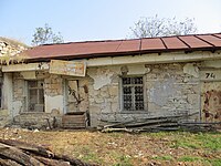
 Semi-ruined Armenian Church of Kyatuk with attached store
 -
 Ruined old Soviet store of Kyatuk


- ^ a b c Hakob Ghahramanyan. "Directory of socio-economic characteristics of NKR administrative-territorial units (2015)".
- ^ Андрей Зубов. "Андрей Зубов. Карабах: Мир и Война". drugoivzgliad.com.
- ^ Sauer, Pjotr (2 October 2023). "'It's a ghost town': UN arrives in Nagorno-Karabakh to find ethnic Armenians have fled". The Guardian. ISSN 0261-3077. Retrieved 9 November 2023.
- ^ "The Results of the 2005 Census of the Nagorno-Karabakh Republic" (PDF). National Statistic Service of the Republic of Artsakh.
- ^ Vahe Antanesyan (2011-11-01). "Creator of Life". imYerevan.
Capital:
Askeran | ||
| Urban communities |  | |
| Rural communities |
| |
| Not under Artsakh control | ||

|
| This Khojaly District location article is a stub. You can help Wikipedia by expanding it. |
|
| This Artsakh location article is a stub. You can help Wikipedia by expanding it. |
Kyatuk / Aghgadik
Քյաթուկ / Ağgədik | |
|---|---|
|
Memorial in Kyatuk | |
Kyatuk / Aghgadik Kyatuk / Aghgadik | |
| Coordinates: 39°54′11″N 46°50′49″E / 39.90306°N 46.84694°E | |
| Country | |
| • District | Khojaly |
| Elevation | 985 m (3,232 ft) |
| Population (2015)
[1] | |
| • Total | 6 |
| Time zone | UTC+4 ( AZT) |
Kyatuk ( Armenian: Քյաթուկ) or Aghgadik ( Azerbaijani: Ağgədik) is a village in the Khojaly District of Azerbaijan, in the region of Nagorno-Karabakh. Until 2023 it was controlled by the breakaway Republic of Artsakh. The village had an ethnic Armenian-majority population [2] until the exodus of the Armenian population of Nagorno-Karabakh following the 2023 Azerbaijani offensive in Nagorno-Karabakh. [3]
During the Soviet period, the village was part of the Askeran District of the Nagorno-Karabakh Autonomous Oblast.
The village is part of the community of Askeran. [1]
The village had 8 inhabitants in 2005, [4] and 6 inhabitants in 2015. [1]
- Mikael Aramyants (1843–1923) – Armenian oil magnate [5]
- Mikayel Varandian (1870–1934) – Armenian revolutionary and historian
-
Semi-ruined Armenian Church of Kyatuk with attached store
-
Ruined old Soviet store of Kyatuk
- ^ a b c Hakob Ghahramanyan. "Directory of socio-economic characteristics of NKR administrative-territorial units (2015)".
- ^ Андрей Зубов. "Андрей Зубов. Карабах: Мир и Война". drugoivzgliad.com.
- ^ Sauer, Pjotr (2 October 2023). "'It's a ghost town': UN arrives in Nagorno-Karabakh to find ethnic Armenians have fled". The Guardian. ISSN 0261-3077. Retrieved 9 November 2023.
- ^ "The Results of the 2005 Census of the Nagorno-Karabakh Republic" (PDF). National Statistic Service of the Republic of Artsakh.
- ^ Vahe Antanesyan (2011-11-01). "Creator of Life". imYerevan.
Capital:
Askeran | ||
| Urban communities | | |
| Rural communities |
| |
| Not under Artsakh control | ||
|
| This Khojaly District location article is a stub. You can help Wikipedia by expanding it. |
|
| This Artsakh location article is a stub. You can help Wikipedia by expanding it. |