| Aïr and Ténéré Addax Sanctuary | |
|---|---|
 300 | |
| Location | Agadez Region, Niger |
| Nearest city | Fachi, Agadez |
| Coordinates | 19°29′4″N 9°30′13″E / 19.48444°N 9.50361°E |
| Area | 12,800 km2 |
| Established | 1 January 1988 |
| Governing body | Parcs Nationaux & Reserves - Niger, UNESCO |
| World Heritage site | 573 |
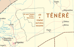
The Aïr and Ténéré Addax Sanctuary is a nature reserve in the north center of the nation of Niger. The reserve forms part of the larger Aïr and Ténéré National Nature Reserve, which is a UNESCO World Heritage Site. The Aïr and Ténéré National Nature Reserve covers 77,360 square kilometres (29,870 sq mi), of which 12,800 square kilometres (4,900 sq mi) form the Aïr and Ténéré Addax Sanctuary.
The Sanctuary exists to protect the critically endangered Addax, which once roamed much of the Aïr Mountains and Ténéré desert. Established 1 January 1988, the sanctuary IUCN type Ia [1] Strict Nature Reserve, the most restricted faunal reserve in Niger.
Plans in the early 1990s to reintroduce captive bred Addax into the sanctuary were derailed by the advent of the 1990s Tuareg insurgency, while reimplementation has been stopped by fighting which erupted in 2007. [2] As of 2006, it was feared that whatever Addax population remained in the sanctuary was no longer self-sustaining. [3]
See also
References
- ^ nep-wcmc site record[ dead link]
- ^ Antelopes: Global Survey and Regional Action Plans pp. 14–21
- ^ Roseline C. Beudels-Jamar, Pierre Devillers, René-Marie Lafontaine and John Newby. ADDAX NASOMACULATUS[ permanent dead link], CMS report, 2007, Institut royal des Sciences naturelles de Belgique.
- Rod East, David P. Mallon, Steven Charles Kingswood. Antelopes: Global Survey and Regional Action Plans. International Union for Conservation of Nature and Natural Resources. IUCN (1988) ISBN 2-8317-0016-7 pp. 14–21, 168
- unep-wcmc site record
- World Database on Protected Areas / UNEP-World Conservation Monitoring Centre (UNEP-WCMC), 2008. Archived 21 August 2006 at the Wayback Machine
- Biodiversity and Protected Areas-- Niger, Earth Trends country profile (2003)
| Aïr and Ténéré Addax Sanctuary | |
|---|---|
 300 | |
| Location | Agadez Region, Niger |
| Nearest city | Fachi, Agadez |
| Coordinates | 19°29′4″N 9°30′13″E / 19.48444°N 9.50361°E |
| Area | 12,800 km2 |
| Established | 1 January 1988 |
| Governing body | Parcs Nationaux & Reserves - Niger, UNESCO |
| World Heritage site | 573 |
The Aïr and Ténéré Addax Sanctuary is a nature reserve in the north center of the nation of Niger. The reserve forms part of the larger Aïr and Ténéré National Nature Reserve, which is a UNESCO World Heritage Site. The Aïr and Ténéré National Nature Reserve covers 77,360 square kilometres (29,870 sq mi), of which 12,800 square kilometres (4,900 sq mi) form the Aïr and Ténéré Addax Sanctuary.
The Sanctuary exists to protect the critically endangered Addax, which once roamed much of the Aïr Mountains and Ténéré desert. Established 1 January 1988, the sanctuary IUCN type Ia [1] Strict Nature Reserve, the most restricted faunal reserve in Niger.
Plans in the early 1990s to reintroduce captive bred Addax into the sanctuary were derailed by the advent of the 1990s Tuareg insurgency, while reimplementation has been stopped by fighting which erupted in 2007. [2] As of 2006, it was feared that whatever Addax population remained in the sanctuary was no longer self-sustaining. [3]
See also
References
- ^ nep-wcmc site record[ dead link]
- ^ Antelopes: Global Survey and Regional Action Plans pp. 14–21
- ^ Roseline C. Beudels-Jamar, Pierre Devillers, René-Marie Lafontaine and John Newby. ADDAX NASOMACULATUS[ permanent dead link], CMS report, 2007, Institut royal des Sciences naturelles de Belgique.
- Rod East, David P. Mallon, Steven Charles Kingswood. Antelopes: Global Survey and Regional Action Plans. International Union for Conservation of Nature and Natural Resources. IUCN (1988) ISBN 2-8317-0016-7 pp. 14–21, 168
- unep-wcmc site record
- World Database on Protected Areas / UNEP-World Conservation Monitoring Centre (UNEP-WCMC), 2008. Archived 21 August 2006 at the Wayback Machine
- Biodiversity and Protected Areas-- Niger, Earth Trends country profile (2003)