| 静岡県東部地震 | |
 | |
| UTC time | 2011-03-15 13:31:46 |
|---|---|
| ISC event | 16318259 |
| USGS- ANSS | ComCat |
| Local date | 15 March 2011 |
| Local time | 22:31:46 |
| Magnitude | 6.0 Mw |
| Depth | 9 km (5.6 mi) |
| Epicenter | 35°18′N 138°42′E / 35.3°N 138.7°E |
| Type | Strike-slip |
| Max. intensity |
MMI VIII (Severe) JMA 6+ |
| Peak acceleration | 1.1 g |
| Casualties | 80 injured |

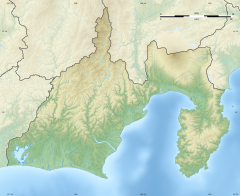
The 2011 Shizuoka earthquake (静岡県東部地震, Shizuoka-ken tо̄bu jishin) occurred approximately 42 km (26 mi) north-northeast of Shizuoka City at 22:31 JST, 15 March 2011. [1] [2] The magnitude was Mw 6.0 or MJMA 6.4, [3] [4] [5] and the depth was 9 km (5.6 mi). [6] The hypocenter of this earthquake is thought to have been near the presumed location of the magma chamber of Mount Fuji. It may have been a triggered earthquake caused by the Tohoku earthquake, which occurred four days earlier, on 11 March 2011. [7] [8] It was sinistral strike-slip fault earthquake. [9] It had a maximum JMA intensity of Shindo 6+ ( Fujinomiya [10]) or VIII (Severe) on the Mercalli intensity scale. [11] The earthquake left 80 people injured, and caused some power outages. [12] [13] [14]
See also
References
- ^ "静岡県東部の地震(2011年3月15日) | 災害カレンダー". Yahoo!天気・災害 (in Japanese). Retrieved 2021-07-01.
- ^ "地震情報 03月15日 22時31分頃発生 最大震度:6強". tenki.jp (in Japanese). 15 March 2011. Retrieved 2021-07-01.
- ^ 「平成23 年(2011 年)東北地方太平洋沖地震」について(第28 報)(Press Release), 25 March 2011. Published by Japan Meteorological Agency.
- ^ 2011年3月15日の静岡県東部の地震 (M6.4) について - 気象庁 地震予知情報課
- ^ "M 6.0 - 6 km NNW of Fujinomiya, Japan". earthquake.usgs.gov. USGS. Retrieved 2 July 2021.
- ^ USGS Earthquake Hazards Program: Preliminary Earthquake Report: EASTERN HONSHU, JAPAN[ permanent dead link]. Neic.usgs.gov (2011-03-15). Retrieved on 2011-04-12.
-
^ 小項目事典, 日本大百科全書(ニッポニカ),デジタル大辞泉,ブリタニカ国際大百科事典.
"東北地方太平洋沖地震とは". コトバンク (in Japanese). Retrieved 2021-07-01.
{{
cite web}}
: CS1 maint: multiple names: authors list ( link) - ^ 東日本沖巨大地震. Sk01.ed.shizuoka.ac.jp. Retrieved on 2011-04-12.
- ^ 2011年3月15日静岡県東部の地震の評価. Jishin.go.jp. Retrieved on 2011-04-17.
- ^ "【図解・社会】東日本大震災・静岡県東部での主な各地の震度(2011年3月15日):時事ドットコム". 時事ドットコム (in Japanese). Retrieved 2021-07-01.
- ^ "2011年3月15日静岡県東部の地震に関する情報". www.jishin.go.jp. Retrieved 2021-07-01.
- ^ "気象庁 | 日本付近で発生した主な被害地震(平成8年以降)". www.data.jma.go.jp. Retrieved 2021-07-01.
- ^ 3月15日静岡県東部の地震に関する被害情報 Archived 2011-09-27 at the Wayback Machine - 静岡県
- ^ 日本テレビ. "静岡県東部で震度6強 24人ケガ|日テレNEWS24". 日テレNEWS24 (in Japanese). Archived from the original on 2011-03-19. Retrieved 2021-07-01.
External links
- 2011年3月15日の静岡県東部の地震 (M6.4) について - 気象庁 地震予知情報課
| 静岡県東部地震 | |
 | |
| UTC time | 2011-03-15 13:31:46 |
|---|---|
| ISC event | 16318259 |
| USGS- ANSS | ComCat |
| Local date | 15 March 2011 |
| Local time | 22:31:46 |
| Magnitude | 6.0 Mw |
| Depth | 9 km (5.6 mi) |
| Epicenter | 35°18′N 138°42′E / 35.3°N 138.7°E |
| Type | Strike-slip |
| Max. intensity |
MMI VIII (Severe) JMA 6+ |
| Peak acceleration | 1.1 g |
| Casualties | 80 injured |

The 2011 Shizuoka earthquake (静岡県東部地震, Shizuoka-ken tо̄bu jishin) occurred approximately 42 km (26 mi) north-northeast of Shizuoka City at 22:31 JST, 15 March 2011. [1] [2] The magnitude was Mw 6.0 or MJMA 6.4, [3] [4] [5] and the depth was 9 km (5.6 mi). [6] The hypocenter of this earthquake is thought to have been near the presumed location of the magma chamber of Mount Fuji. It may have been a triggered earthquake caused by the Tohoku earthquake, which occurred four days earlier, on 11 March 2011. [7] [8] It was sinistral strike-slip fault earthquake. [9] It had a maximum JMA intensity of Shindo 6+ ( Fujinomiya [10]) or VIII (Severe) on the Mercalli intensity scale. [11] The earthquake left 80 people injured, and caused some power outages. [12] [13] [14]
See also
References
- ^ "静岡県東部の地震(2011年3月15日) | 災害カレンダー". Yahoo!天気・災害 (in Japanese). Retrieved 2021-07-01.
- ^ "地震情報 03月15日 22時31分頃発生 最大震度:6強". tenki.jp (in Japanese). 15 March 2011. Retrieved 2021-07-01.
- ^ 「平成23 年(2011 年)東北地方太平洋沖地震」について(第28 報)(Press Release), 25 March 2011. Published by Japan Meteorological Agency.
- ^ 2011年3月15日の静岡県東部の地震 (M6.4) について - 気象庁 地震予知情報課
- ^ "M 6.0 - 6 km NNW of Fujinomiya, Japan". earthquake.usgs.gov. USGS. Retrieved 2 July 2021.
- ^ USGS Earthquake Hazards Program: Preliminary Earthquake Report: EASTERN HONSHU, JAPAN[ permanent dead link]. Neic.usgs.gov (2011-03-15). Retrieved on 2011-04-12.
-
^ 小項目事典, 日本大百科全書(ニッポニカ),デジタル大辞泉,ブリタニカ国際大百科事典.
"東北地方太平洋沖地震とは". コトバンク (in Japanese). Retrieved 2021-07-01.
{{
cite web}}
: CS1 maint: multiple names: authors list ( link) - ^ 東日本沖巨大地震. Sk01.ed.shizuoka.ac.jp. Retrieved on 2011-04-12.
- ^ 2011年3月15日静岡県東部の地震の評価. Jishin.go.jp. Retrieved on 2011-04-17.
- ^ "【図解・社会】東日本大震災・静岡県東部での主な各地の震度(2011年3月15日):時事ドットコム". 時事ドットコム (in Japanese). Retrieved 2021-07-01.
- ^ "2011年3月15日静岡県東部の地震に関する情報". www.jishin.go.jp. Retrieved 2021-07-01.
- ^ "気象庁 | 日本付近で発生した主な被害地震(平成8年以降)". www.data.jma.go.jp. Retrieved 2021-07-01.
- ^ 3月15日静岡県東部の地震に関する被害情報 Archived 2011-09-27 at the Wayback Machine - 静岡県
- ^ 日本テレビ. "静岡県東部で震度6強 24人ケガ|日テレNEWS24". 日テレNEWS24 (in Japanese). Archived from the original on 2011-03-19. Retrieved 2021-07-01.
External links
- 2011年3月15日の静岡県東部の地震 (M6.4) について - 気象庁 地震予知情報課

