Študa | |
|---|---|
 | |
| Coordinates: 46°7′30.62″N 14°35′57.45″E / 46.1251722°N 14.5992917°E | |
| Country |
|
| Traditional region | Upper Carniola |
| Statistical region | Central Slovenia |
| Municipality | Domžale |
| Elevation | 291 m (955 ft) |
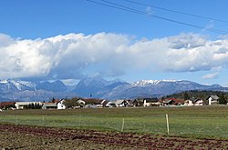
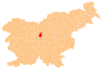
Študa (pronounced [ˈʃtuːda]; in older sources also Studa; [1] [2] German: Studa [3]) is a former village that is now part of Domžale in the Upper Carniola region of Slovenia. [4]
Geography
Študa is a sprawling settlement south of the main core of Domžale. It lies along the lower reaches of Mlinščica Creek, a tributary of the Kamnik Bistrica. [2] [5] The soil in the area is sandy and the fields to the south are intensely cultivated. [2]
Name
Študa was mentioned in historical sources as Stude in a document from 1205 (in which a witness signed himself as Grifo de Stude). [6]: 56
History
Študa was the very first of the settlements comprising Domžale to be mentioned in historical sources, in 1205. [2] [6]: 56 During the Middle Ages, the various farms in Študa were held in feud to a variety of estates (Smlednik, Bogenšperk, Križ, and Bokavce) and parishes (Mengeš and Kamnik). [6]: 160 The region was affected by the plague around 1600, as evidenced by the Dimec plague column ( Slovene: Dimčevo znamenje) dating from 1602. [2] [6]: 167 The shrine stands west of the village along the road to Dragomelj. [6]: 167 The farmers in Študa held common land until 1882, when it was divided. [6]: 101 Along with Spodnje Domžale, Stob, and Zgornje Domžale, Študa was amalgamated into Domžale in 1925, ending its existence as an independent settlement. [2] [6]: 7 A radio transmitter capable of broadcasting across Slovenia was set up in the meadow west of Študa in 1928. [2]
References
- ^ Leksikon občin kraljestev in dežel zastopanih v državnem zboru, vol. 6: Kranjsko. 1906. Vienna: C. Kr. Dvorna in Državna Tiskarna, p. 24.
- ^ a b c d e f g Krajevni leksikon Dravske Banovine. 1937. Ljubljana: Zveza za tujski promet za Slovenijo, pp. 181–182.
- ^ Intelligenzblatt zur Laibacher Zeitung, no. 141. 24 November 1849, p. 20.
- ^ Domžale municipal site
- ^ Savnik, Roman, ed. 1971. Krajevni leksikon Slovenije, vol. 2. Ljubljana: Državna založba Slovenije, p. 83.
- ^ a b c d e f g Bernik, Franc. 1925. Z nekdanje Goričice. Kamnik: Author.
External links
Študa | |
|---|---|
 | |
| Coordinates: 46°7′30.62″N 14°35′57.45″E / 46.1251722°N 14.5992917°E | |
| Country |
|
| Traditional region | Upper Carniola |
| Statistical region | Central Slovenia |
| Municipality | Domžale |
| Elevation | 291 m (955 ft) |
Študa (pronounced [ˈʃtuːda]; in older sources also Studa; [1] [2] German: Studa [3]) is a former village that is now part of Domžale in the Upper Carniola region of Slovenia. [4]
Geography
Študa is a sprawling settlement south of the main core of Domžale. It lies along the lower reaches of Mlinščica Creek, a tributary of the Kamnik Bistrica. [2] [5] The soil in the area is sandy and the fields to the south are intensely cultivated. [2]
Name
Študa was mentioned in historical sources as Stude in a document from 1205 (in which a witness signed himself as Grifo de Stude). [6]: 56
History
Študa was the very first of the settlements comprising Domžale to be mentioned in historical sources, in 1205. [2] [6]: 56 During the Middle Ages, the various farms in Študa were held in feud to a variety of estates (Smlednik, Bogenšperk, Križ, and Bokavce) and parishes (Mengeš and Kamnik). [6]: 160 The region was affected by the plague around 1600, as evidenced by the Dimec plague column ( Slovene: Dimčevo znamenje) dating from 1602. [2] [6]: 167 The shrine stands west of the village along the road to Dragomelj. [6]: 167 The farmers in Študa held common land until 1882, when it was divided. [6]: 101 Along with Spodnje Domžale, Stob, and Zgornje Domžale, Študa was amalgamated into Domžale in 1925, ending its existence as an independent settlement. [2] [6]: 7 A radio transmitter capable of broadcasting across Slovenia was set up in the meadow west of Študa in 1928. [2]
References
- ^ Leksikon občin kraljestev in dežel zastopanih v državnem zboru, vol. 6: Kranjsko. 1906. Vienna: C. Kr. Dvorna in Državna Tiskarna, p. 24.
- ^ a b c d e f g Krajevni leksikon Dravske Banovine. 1937. Ljubljana: Zveza za tujski promet za Slovenijo, pp. 181–182.
- ^ Intelligenzblatt zur Laibacher Zeitung, no. 141. 24 November 1849, p. 20.
- ^ Domžale municipal site
- ^ Savnik, Roman, ed. 1971. Krajevni leksikon Slovenije, vol. 2. Ljubljana: Državna založba Slovenije, p. 83.
- ^ a b c d e f g Bernik, Franc. 1925. Z nekdanje Goričice. Kamnik: Author.

