Šajkaš
Шајкаш (
Serbian) | |
|---|---|
 Main street and the Orthodox Church | |
| Coordinates: 45°16′N 20°05′E / 45.267°N 20.083°E | |
| Country | |
| Province | |
| District | South Bačka District |
| Municipality | Titel |
| Area | |
| • Total | 38.9 km2 (15.0 sq mi) |
| Elevation | 78 m (256 ft) |
| Population (2011) | |
| • Total | 4,374 |
| • Density | 110/km2 (290/sq mi) |
| Time zone | UTC+1 ( CET) |
| • Summer ( DST) | UTC+2 ( CEST) |

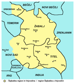
Šajkaš ( Serbian Cyrillic: Шајкаш; Hungarian: Sajkásszentiván) is a village located in the Titel municipality, South Bačka District, Vojvodina, Serbia. As of 2011 census, it has a population of 4,374 inhabitants.
Name
In Serbian the village is known as Šajkaš (Шајкаш), in Croatian as Šajkaš, in Hungarian as Sajkásszentiván, and in German as Schatzdorf or Schajkasch-Sentiwan.
History
The Šajkaška district was the scene of a notorious massacre during the occupation of Bačka by the Hungarian army in January 1942. This cost almost 900 lives. The German minority left the village in 1944.
Demographics
| Year | Pop. | ±% p.a. |
|---|---|---|
| 1961 | 2,825 | — |
| 1971 | 2,987 | +0.56% |
| 1981 | 3,541 | +1.72% |
| 1991 | 3,828 | +0.78% |
| 2002 | 4,848 | +2.17% |
| 2011 | 4,374 | −1.14% |
As of 2011 census, the village of Šajkaš has a population of 4,374 inhabitants.
See also
References
- Slobodan Ćurčić: Broj stanovnika Vojvodine (Novi Sad, 1996).
External links
Šajkaš
Шајкаш (
Serbian) | |
|---|---|
 Main street and the Orthodox Church | |
| Coordinates: 45°16′N 20°05′E / 45.267°N 20.083°E | |
| Country | |
| Province | |
| District | South Bačka District |
| Municipality | Titel |
| Area | |
| • Total | 38.9 km2 (15.0 sq mi) |
| Elevation | 78 m (256 ft) |
| Population (2011) | |
| • Total | 4,374 |
| • Density | 110/km2 (290/sq mi) |
| Time zone | UTC+1 ( CET) |
| • Summer ( DST) | UTC+2 ( CEST) |

Šajkaš ( Serbian Cyrillic: Шајкаш; Hungarian: Sajkásszentiván) is a village located in the Titel municipality, South Bačka District, Vojvodina, Serbia. As of 2011 census, it has a population of 4,374 inhabitants.
Name
In Serbian the village is known as Šajkaš (Шајкаш), in Croatian as Šajkaš, in Hungarian as Sajkásszentiván, and in German as Schatzdorf or Schajkasch-Sentiwan.
History
The Šajkaška district was the scene of a notorious massacre during the occupation of Bačka by the Hungarian army in January 1942. This cost almost 900 lives. The German minority left the village in 1944.
Demographics
| Year | Pop. | ±% p.a. |
|---|---|---|
| 1961 | 2,825 | — |
| 1971 | 2,987 | +0.56% |
| 1981 | 3,541 | +1.72% |
| 1991 | 3,828 | +0.78% |
| 2002 | 4,848 | +2.17% |
| 2011 | 4,374 | −1.14% |
As of 2011 census, the village of Šajkaš has a population of 4,374 inhabitants.
See also
References
- Slobodan Ćurčić: Broj stanovnika Vojvodine (Novi Sad, 1996).
External links


