
Ōoka River (大岡川, Ōoka-gawa) is a river that flows through Yokohama, Japan. It is 14 km long and over 80 bridges are built on the river. There are large numbers of cherry trees located near the river.
-
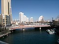 The mouth of the Ōoka River
 -
![Chōjabashi (長者橋 [ja])](https://upload.wikimedia.org/wikipedia/commons/thumb/3/3e/Ch%C5%8Djabashi_02.JPG/120px-Ch%C5%8Djabashi_02.JPG) Chōjabashi ( 長者橋)
Chōjabashi ( 長者橋) -
 Idogayabashi (井土ヶ谷橋)
 -
![The source of the Ōoka River, in Hitorizawa-Chō (氷取沢町 [ja])](https://upload.wikimedia.org/wikipedia/commons/thumb/a/aa/Oooka-River%2CRiverhead.JPG/120px-Oooka-River%2CRiverhead.JPG) The source of the Ōoka River, in Hitorizawa-Chō ( 氷取沢町)
The source of the Ōoka River, in Hitorizawa-Chō ( 氷取沢町)
150203.JPG)
![Chōjabashi (長者橋 [ja])](/info/en/?search=File:Ch%C5%8Djabashi_02.JPG)
.jpg)
![The source of the Ōoka River, in Hitorizawa-Chō (氷取沢町 [ja])](/info/en/?search=File:Oooka-River,Riverhead.JPG)
| |||||||||||||||
| |||||||||||||||
| |||||||||||||||
| |||||||||||||||
| International | |
|---|---|
| National | |
|
| This Kanagawa Prefecture location article is a stub. You can help Wikipedia by expanding it. |
|
| This article related to a river in Japan is a stub. You can help Wikipedia by expanding it. |
Ōoka River (大岡川, Ōoka-gawa) is a river that flows through Yokohama, Japan. It is 14 km long and over 80 bridges are built on the river. There are large numbers of cherry trees located near the river.
-
The mouth of the Ōoka River
-
Chōjabashi ( 長者橋)
-
Idogayabashi (井土ヶ谷橋)
-
The source of the Ōoka River, in Hitorizawa-Chō ( 氷取沢町)
| |||||||||||||||
| |||||||||||||||
| |||||||||||||||
| |||||||||||||||
| International | |
|---|---|
| National | |
|
| This Kanagawa Prefecture location article is a stub. You can help Wikipedia by expanding it. |
|
| This article related to a river in Japan is a stub. You can help Wikipedia by expanding it. |