Photos • Location
This article needs additional citations for
verification. (September 2017) |
| Čierna voda | |
|---|---|
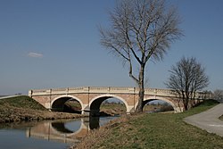
 Bridge near
Kráľová pri Senci | |
| Physical characteristics | |
| Source | |
| • location | Little Carpathians |
| Mouth | |
• location | Little Danube |
• coordinates | 47°57′33″N 17°52′40″E / 47.9593°N 17.8779°E |
| Length | 105.5 km (65.6 mi) |
| Basin features | |
| Progression | Little Danube→ Váh→ Danube→ Black Sea |
| Tributaries | |
| • left | Dudváh |
The Čierna voda is a lowland river in western Slovakia. It is 105.5 km long. [1] Its source is in the Little Carpathians, near the town Svätý Jur. Near the town Čierna Voda, it is joined by its largest tributary: the Dudváh. It discharges into the Little Danube river near the village Dolný Chotár.
References
This article needs additional citations for
verification. (September 2017) |
| Čierna voda | |
|---|---|
 Bridge near
Kráľová pri Senci | |
| Physical characteristics | |
| Source | |
| • location | Little Carpathians |
| Mouth | |
• location | Little Danube |
• coordinates | 47°57′33″N 17°52′40″E / 47.9593°N 17.8779°E |
| Length | 105.5 km (65.6 mi) |
| Basin features | |
| Progression | Little Danube→ Váh→ Danube→ Black Sea |
| Tributaries | |
| • left | Dudváh |
The Čierna voda is a lowland river in western Slovakia. It is 105.5 km long. [1] Its source is in the Little Carpathians, near the town Svätý Jur. Near the town Čierna Voda, it is joined by its largest tributary: the Dudváh. It discharges into the Little Danube river near the village Dolný Chotár.
References
