Újezd | |
|---|---|
 Common with Chapel of the Sacred Heart | |
_Flag_ver2.png) Flag _CoA_ver2.png) Coat of arms | |
 Újezd Location in the Czech Republic | |
| Coordinates: 49°49′53″N 13°50′15″E / 49.83139°N 13.83750°E | |
| Country | |
| Region | Central Bohemian |
| District | Beroun |
| First mentioned | 1399 |
| Area | |
| • Total | 10.41 km2 (4.02 sq mi) |
| Elevation | 414 m (1,358 ft) |
| Population (2023-01-01)
[1] | |
| • Total | 681 |
| • Density | 65/km2 (170/sq mi) |
| Time zone | UTC+1 ( CET) |
| • Summer ( DST) | UTC+2 ( CEST) |
| Postal code | 267 61 |
| Website |
www |
Újezd is a municipality and village in Beroun District in the Central Bohemian Region of the Czech Republic. It has about 700 inhabitants.
Újezd is located about 22 kilometres (14 mi) southwest of Beroun and 50 km (31 mi) southwest of Prague.
History
The first written mention of Újezd is from 1399. [2]
Demographics
| Year | Pop. | ±% |
|---|---|---|
| 1869 | 525 | — |
| 1880 | 506 | −3.6% |
| 1890 | 517 | +2.2% |
| 1900 | 579 | +12.0% |
| 1910 | 658 | +13.6% |
| 1921 | 680 | +3.3% |
| 1930 | 728 | +7.1% |
| 1950 | 652 | −10.4% |
| 1961 | 683 | +4.8% |
| 1970 | 643 | −5.9% |
| 1980 | 619 | −3.7% |
| 1991 | 548 | −11.5% |
| 2001 | 555 | +1.3% |
| 2011 | 616 | +11.0% |
| 2021 | 680 | +10.4% |
| Source: Censuses [3] [4] | ||
Gallery
-
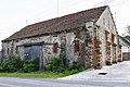 Old barn
 -
 Side street
 -
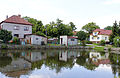 Common pond


References
- ^ "Population of Municipalities – 1 January 2023". Czech Statistical Office. 2023-05-23.
- ^ "Úvodem o obci Újezd" (in Czech). Obec Újezd. Retrieved 2021-07-05.
- ^ "Historický lexikon obcí České republiky 1869–2011 – Okres Beroun" (in Czech). Czech Statistical Office. 2015-12-21. pp. 11–12.
- ^ "Population Census 2021: Population by sex". Public Database. Czech Statistical Office. 2021-03-27.
External links
| Authority control databases: National |
|---|
|
| This Central Bohemian Region location article is a stub. You can help Wikipedia by expanding it. |
Újezd | |
|---|---|
|
Common with Chapel of the Sacred Heart | |
|
Flag Coat of arms | |
Újezd Location in the Czech Republic | |
| Coordinates: 49°49′53″N 13°50′15″E / 49.83139°N 13.83750°E | |
| Country | |
| Region | Central Bohemian |
| District | Beroun |
| First mentioned | 1399 |
| Area | |
| • Total | 10.41 km2 (4.02 sq mi) |
| Elevation | 414 m (1,358 ft) |
| Population (2023-01-01)
[1] | |
| • Total | 681 |
| • Density | 65/km2 (170/sq mi) |
| Time zone | UTC+1 ( CET) |
| • Summer ( DST) | UTC+2 ( CEST) |
| Postal code | 267 61 |
| Website |
www |
Újezd is a municipality and village in Beroun District in the Central Bohemian Region of the Czech Republic. It has about 700 inhabitants.
Újezd is located about 22 kilometres (14 mi) southwest of Beroun and 50 km (31 mi) southwest of Prague.
History
The first written mention of Újezd is from 1399. [2]
Demographics
| Year | Pop. | ±% |
|---|---|---|
| 1869 | 525 | — |
| 1880 | 506 | −3.6% |
| 1890 | 517 | +2.2% |
| 1900 | 579 | +12.0% |
| 1910 | 658 | +13.6% |
| 1921 | 680 | +3.3% |
| 1930 | 728 | +7.1% |
| 1950 | 652 | −10.4% |
| 1961 | 683 | +4.8% |
| 1970 | 643 | −5.9% |
| 1980 | 619 | −3.7% |
| 1991 | 548 | −11.5% |
| 2001 | 555 | +1.3% |
| 2011 | 616 | +11.0% |
| 2021 | 680 | +10.4% |
| Source: Censuses [3] [4] | ||
Gallery
-
Old barn
-
Side street
-
Common pond
References
- ^ "Population of Municipalities – 1 January 2023". Czech Statistical Office. 2023-05-23.
- ^ "Úvodem o obci Újezd" (in Czech). Obec Újezd. Retrieved 2021-07-05.
- ^ "Historický lexikon obcí České republiky 1869–2011 – Okres Beroun" (in Czech). Czech Statistical Office. 2015-12-21. pp. 11–12.
- ^ "Population Census 2021: Population by sex". Public Database. Czech Statistical Office. 2021-03-27.
External links
| Authority control databases: National |
|---|
|
| This Central Bohemian Region location article is a stub. You can help Wikipedia by expanding it. |