You can help expand this article with text translated from
the corresponding article in French. (December 2008) Click [show] for important translation instructions.
|
Échenevex | |
|---|---|
Commune | |
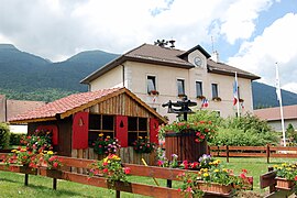
 Town hall | |
| Coordinates: 46°18′34″N 6°02′12″E / 46.3094°N 6.0367°E | |
| Country | France |
| Region | Auvergne-Rhône-Alpes |
| Department | Ain |
| Arrondissement | Gex |
| Canton | Thoiry |
| Intercommunality | CA Pays de Gex |
| Government | |
| • Mayor (2020–2026) | Isabelle Passuello [1] |
| Area 1 | 16.44 km2 (6.35 sq mi) |
| Population (2021)
[2] | 2,127 |
| • Density | 130/km2 (340/sq mi) |
| Time zone | UTC+01:00 ( CET) |
| • Summer ( DST) | UTC+02:00 ( CEST) |
| INSEE/Postal code |
01153 /01170 |
| Elevation | 490–1,682 m (1,608–5,518 ft) (avg. 635 m or 2,083 ft) |
| 1 French Land Register data, which excludes lakes, ponds, glaciers > 1 km2 (0.386 sq mi or 247 acres) and river estuaries. | |
Échenevex ( [eʃnəvɛ]) is a commune in the Ain department in eastern France. As of 2020 [update], it is the commune with the fifth highest median per capita income (€51,020 per year) in France. [3]
Échenevex is located between the Jura mountains and the Lake Geneva region. It is situated on the slopes of the Jura mountains, just 3 km south of Gex. The Large Hadron Collider passes under Échenevex, about 100 m below the surface. Echenevex consists partly of the Jura mountains natural park area and is approximately 8 minutes from the Crozet Telecabine ski station, and 15 minutes from Geneva International Airport.
| Year | Pop. | ±% p.a. |
|---|---|---|
| 1968 | 282 | — |
| 1975 | 371 | +4.00% |
| 1982 | 643 | +8.17% |
| 1990 | 997 | +5.64% |
| 1999 | 1,197 | +2.05% |
| 2007 | 1,500 | +2.86% |
| 2012 | 1,813 | +3.86% |
| 2017 | 2,132 | +3.29% |
| Source: INSEE [4] | ||
- ^ "Répertoire national des élus: les maires" (in French). data.gouv.fr, Plateforme ouverte des données publiques françaises. 13 September 2022. Archived from the original on 28 June 2020. Retrieved 22 November 2022.
- ^ "Populations légales 2021" (in French). The National Institute of Statistics and Economic Studies. 28 December 2023.
- ^ Structure et distribution des revenus, inégalité des niveaux de vie en 2020 Archived 28 January 2024 at the Wayback Machine, Base niveau communes en 2020, INSEE.
- ^ Population en historique depuis 1968 Archived 2 September 2022 at the Wayback Machine, INSEE
You can help expand this article with text translated from
the corresponding article in French. (December 2008) Click [show] for important translation instructions.
|
Échenevex | |
|---|---|
Commune | |
 Town hall | |
| Coordinates: 46°18′34″N 6°02′12″E / 46.3094°N 6.0367°E | |
| Country | France |
| Region | Auvergne-Rhône-Alpes |
| Department | Ain |
| Arrondissement | Gex |
| Canton | Thoiry |
| Intercommunality | CA Pays de Gex |
| Government | |
| • Mayor (2020–2026) | Isabelle Passuello [1] |
| Area 1 | 16.44 km2 (6.35 sq mi) |
| Population (2021)
[2] | 2,127 |
| • Density | 130/km2 (340/sq mi) |
| Time zone | UTC+01:00 ( CET) |
| • Summer ( DST) | UTC+02:00 ( CEST) |
| INSEE/Postal code |
01153 /01170 |
| Elevation | 490–1,682 m (1,608–5,518 ft) (avg. 635 m or 2,083 ft) |
| 1 French Land Register data, which excludes lakes, ponds, glaciers > 1 km2 (0.386 sq mi or 247 acres) and river estuaries. | |
Échenevex ( [eʃnəvɛ]) is a commune in the Ain department in eastern France. As of 2020 [update], it is the commune with the fifth highest median per capita income (€51,020 per year) in France. [3]
Échenevex is located between the Jura mountains and the Lake Geneva region. It is situated on the slopes of the Jura mountains, just 3 km south of Gex. The Large Hadron Collider passes under Échenevex, about 100 m below the surface. Echenevex consists partly of the Jura mountains natural park area and is approximately 8 minutes from the Crozet Telecabine ski station, and 15 minutes from Geneva International Airport.
| Year | Pop. | ±% p.a. |
|---|---|---|
| 1968 | 282 | — |
| 1975 | 371 | +4.00% |
| 1982 | 643 | +8.17% |
| 1990 | 997 | +5.64% |
| 1999 | 1,197 | +2.05% |
| 2007 | 1,500 | +2.86% |
| 2012 | 1,813 | +3.86% |
| 2017 | 2,132 | +3.29% |
| Source: INSEE [4] | ||
- ^ "Répertoire national des élus: les maires" (in French). data.gouv.fr, Plateforme ouverte des données publiques françaises. 13 September 2022. Archived from the original on 28 June 2020. Retrieved 22 November 2022.
- ^ "Populations légales 2021" (in French). The National Institute of Statistics and Economic Studies. 28 December 2023.
- ^ Structure et distribution des revenus, inégalité des niveaux de vie en 2020 Archived 28 January 2024 at the Wayback Machine, Base niveau communes en 2020, INSEE.
- ^ Population en historique depuis 1968 Archived 2 September 2022 at the Wayback Machine, INSEE


