Much of my work on Wikipedia relates to geography and/or history.
Counties, townships and towns
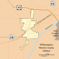
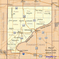
Being a Hoosier, my focus was originally on Indiana towns, townships, and counties, but that has expanded to other parts of the nation. I created most of the Indiana township articles and produced a locator map for each, and produced the locators for townships in Illinois and other states as well. I am willing to create other such maps if the need arises; this can be often done on a semi-automated basis using custom-written scripts (which depend on PHP MapScript, part of the open-source MapServer system) and freely-available mapping data from the United States Census, the National Atlas, and other sources.
- Samples of maps I have created
-

-
-
-

-

-

-

-


Atlas maps
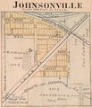
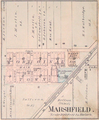
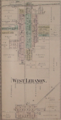
When it comes to small towns, old atlases and newspapers on microfilm are wonderful resources. It's interesting how people in the 1870s in the midwest used the same language we do now, naturally, and yet once in a while it's difficult to know what they were talking about when reading old newspaper articles; frames of reference have shifted over the years. Below are a few of the maps I've scanned from an 1877 atlas, which I find rather fascinating. These have also been set up with overlays for viewing in Google Earth, per Geocoding/Overlay, which lets you view old maps on top of current satellite images. A useful tool here was the Microsoft Research Image Composite Editor, a free tool which allowed me to scan quadrants of the atlas' large pages and then stitch them together to form single complete images; it's also great for making panoramic images out of sets of photographs.
- Maps from the 1877 Atlas of Warren County, Indiana
-

-

-

-
-
-

-

-

-
-

-


Roads
In order to help provide better in-article descriptions of Indiana state roads, I have created many maps for those articles using MapScript. I also created a number of Indiana state road articles, ensuring that each road had an article, and added sourced milepost data to those and many existing articles.

.svg)


Photography
Another goal is to provide at least one photograph of each of the towns and points of interest in Vermilion County, Illinois, for inclusion in the related articles. You can view my photographs on Wikimedia Commons.
- Photographs of Vermilion County
-

Library in Ridge Farm, Illinois -

-

Museum in Westville, Illinois -
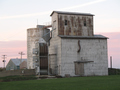
Grain elevator in Cheneyville, Illinois -

-

Iron bridge near Armstrong, Illinois


_statue.png)

About me
|
| This user helped promote Warren County, Indiana to featured article status. |
Warren County, Indiana was the first United States county article to be promoted to Featured Article status, in February 2011, and it is still the only one.
|
| This user helped promote Jefferson Davis to featured article status. |
|
| This editor won the Half Million Award for bringing Jefferson Davis to Featured Article status. |

|
| |||||||
|
|
| ||||||
|
|
| ||||||
|
|
| ||||||
|
|
|
- Wikipedia featured article contributors
- Wikipedians who have won a Million Award
- Wikipedia autopatrollers
- User en-N
- Wikipedians in Indiana
- Wikipedians in the United States
- Wikipedian martial artists
- Inclusionist Wikipedians
- WikiProject Indiana participants
- Wikipedians interested in Indiana
- WikiProject Illinois participants
- Wikipedians interested in Illinois
- WikiProject Martial arts participants
- Wikipedians interested in martial arts
- Wikipedians interested in the United States
- WikiProject United States participants
- WikiProject U.S. Roads participants
- WikiProject U.S. Roads/Maps Department participants
Much of my work on Wikipedia relates to geography and/or history.
Counties, townships and towns
Being a Hoosier, my focus was originally on Indiana towns, townships, and counties, but that has expanded to other parts of the nation. I created most of the Indiana township articles and produced a locator map for each, and produced the locators for townships in Illinois and other states as well. I am willing to create other such maps if the need arises; this can be often done on a semi-automated basis using custom-written scripts (which depend on PHP MapScript, part of the open-source MapServer system) and freely-available mapping data from the United States Census, the National Atlas, and other sources.
- Samples of maps I have created
-
-
-
-
-
-
-
-
Atlas maps
When it comes to small towns, old atlases and newspapers on microfilm are wonderful resources. It's interesting how people in the 1870s in the midwest used the same language we do now, naturally, and yet once in a while it's difficult to know what they were talking about when reading old newspaper articles; frames of reference have shifted over the years. Below are a few of the maps I've scanned from an 1877 atlas, which I find rather fascinating. These have also been set up with overlays for viewing in Google Earth, per Geocoding/Overlay, which lets you view old maps on top of current satellite images. A useful tool here was the Microsoft Research Image Composite Editor, a free tool which allowed me to scan quadrants of the atlas' large pages and then stitch them together to form single complete images; it's also great for making panoramic images out of sets of photographs.
- Maps from the 1877 Atlas of Warren County, Indiana
-
-
-
-
-
-
-
-
-
-
-
Roads
In order to help provide better in-article descriptions of Indiana state roads, I have created many maps for those articles using MapScript. I also created a number of Indiana state road articles, ensuring that each road had an article, and added sourced milepost data to those and many existing articles.
Photography
Another goal is to provide at least one photograph of each of the towns and points of interest in Vermilion County, Illinois, for inclusion in the related articles. You can view my photographs on Wikimedia Commons.
- Photographs of Vermilion County
-
Library in Ridge Farm, Illinois -
-
Museum in Westville, Illinois -
Grain elevator in Cheneyville, Illinois -
-
Iron bridge near Armstrong, Illinois
About me
|
| This user helped promote Warren County, Indiana to featured article status. |
Warren County, Indiana was the first United States county article to be promoted to Featured Article status, in February 2011, and it is still the only one.
|
| This user helped promote Jefferson Davis to featured article status. |
|
| This editor won the Half Million Award for bringing Jefferson Davis to Featured Article status. |
|
| |||||||
|
|
| ||||||
|
|
| ||||||
|
|
| ||||||
|
|
|
- Wikipedia featured article contributors
- Wikipedians who have won a Million Award
- Wikipedia autopatrollers
- User en-N
- Wikipedians in Indiana
- Wikipedians in the United States
- Wikipedian martial artists
- Inclusionist Wikipedians
- WikiProject Indiana participants
- Wikipedians interested in Indiana
- WikiProject Illinois participants
- Wikipedians interested in Illinois
- WikiProject Martial arts participants
- Wikipedians interested in martial arts
- Wikipedians interested in the United States
- WikiProject United States participants
- WikiProject U.S. Roads participants
- WikiProject U.S. Roads/Maps Department participants