| This is the
talk page for discussing improvements to the
Berlin article. This is not a forum for general discussion of the article's subject. |
Article policies
|
| Find sources: Google ( books · news · scholar · free images · WP refs) · FENS · JSTOR · TWL |
| Archives: 1, 2, 3, 4, 5, 6, 7 |
|
| This article is written in American English, which has its own spelling conventions (color, defense, traveled) and some terms that are used in it may be different or absent from other varieties of English. According to the relevant style guide, this should not be changed without broad consensus. |
 | Berlin was one of the Geography and places good articles, but it has been removed from the list. There are suggestions below for improving the article to meet the good article criteria. Once these issues have been addressed, the article can be renominated. Editors may also seek a reassessment of the decision if they believe there was a mistake. | ||||||||||||||||||||||||
| |||||||||||||||||||||||||
|
| This It is of interest to the following WikiProjects: |
||||||||||||||||||||||||||||||||||||||||||||||||||||||||||||||||||
| |||||||||||||||||||||||||||||||||||||||||||||||||||||||||||||||||||


.svg)
.svg)


|
|
|
Daily pageviews of this article
A graph should have been displayed here but
graphs are temporarily disabled. Until they are enabled again, visit the interactive graph at
pageviews.wmcloud.org |
Please don’t confuse the Berlin metropolitan area as Wikipedia defines a Metropolitan area with the “Capital” region as some officials/agencies in Berlin-Brandenburg would like to define the region. According to Wikipedia: “A metropolitan area, metro area or metro is a region consisting of a densely populated urban core and its less-populated surrounding territories, sharing industry, infrastructure, and housing” – note that farming and other distant rural areas are not included. The metro area is shown for example as the yellow parts of the maps and by the lists of towns. Personally, I would also say it’s the area you can reach by public transport with a Berlin ABC ticket. The given reference http://www.berlin-brandenburg.de/daten-fakten/ also refers this as “Berliner Umland”.
The “Capital Region Berlin-Brandenburg” is a construction that government agencies are trying to push, but it simply includes all of Brandenburg with Berlin. It is true, that in the wider sense Brandenburg’s economy is generally, but not exclusively, oriented towards Berlin. Some day they may even become politically united. However, it is stretching it a bit far to say that vast rural areas such as the forests of the Uckermark or the swamps of the Spreewald belong to the metropolitan area of Berlin. It would be like saying all of Connecticut is part of the Hartford metropolitan area.
So, please adhere to the definition set by Wikipedia and do not follow some megalomaniac political redefinition. Alandeus ( talk) 13:35, 7 February 2013 (UTC)
- Hello :) It is not up to us or Wikipedia to define Berlin metropolitan, that is up to The state of Berlin and Brandenburg, or the German Federal State. If the official numbers are 6 million then it is 6 million, we are not the judgers of that, we follow the official figures, and fact is that Berlin metropolitan are Berlin-Brandenburg. and the links clearly defines the Berlin-Brandenburg as Berlins metro area. — Preceding unsigned comment added by 86.52.81.168 ( talk) 18:25, 7 February 2013 (UTC)
- I’m sorry User 86.52.81.168, but in the encyclopedic realm of Wikipedia, its definitions are quite sound (see above). If some well-meaning government officials for the Berlin/Brandenburg Metropolitan Region have a different idea of what a metropolitan area is, they are welcome to espouse something else on their own “official” websites, no matter how off the mark they are. What they are actually advocating is simply a much larger regional area with a real metropolitan area in the middle as a focal point. The faraway fields of Brandenburg only belong to the Berlin area in so far as that is where the Berliners get their vegetables from for example or where they go for a weekend getaway. Greetings from Berlin, yours Alandeus ( talk) 09:12, 8 February 2013 (UTC)
- Official definitions are all we need with reliable links, the figure of 4.5 mio people don't have any link, but the claims of 6 mio people does, so that is the guideline and what we can use as a reliable source.
- Wikipedia is not a place to make definitions, but a encyclopedia, to put reliable content. At least let's change the figure to include 6 mio people.
- But is must say that you don't recognize the official figures from the states of Berlin and Brandenburg plus IKM (Initiativkreises Europäische Metropolregionen in Deutschland) are not in the spirit if Wikipedia, where reliable sources are all we recognized. The German language site on Wikipedia Metropolregion Berlin/Brandenburg recognized the links, why not on the English language site? — Preceding unsigned comment added by 86.52.81.168 ( talk) 22:43, 8 February 2013 (UTC)
- Wikipedia is a place to make definitions. When reviewing Metropolitan Areas it must have a fundamental definition as a benchmark when collecting and comparing data from many different sources. Some “official” sites seem to make their area larger than what actual metropolitan are for whatever interests they may have. Sure, information from these sites is useful, but only insofar as it does not distort encyclopedic evaluation.
- About those 4.5 million inhabitants: The “Daten und Fakten zur Hauptstadtregion“ page ( http://www.berlin-brandenburg.de/daten-fakten/) has those population figures in the middle and at the bottom of the page: about 3.5 for Berlin, 900 thousand for the area around Berlin (“Berliner Umland”) and 1.6 million for the rest of Brandenburg. I’m sure these latter, more distant Brandenburgers would be appalled to be considered being part of Berlin. Alandeus ( talk) 10:01, 11 February 2013 (UTC)
- The same site say that "Berlin und Brandenburg bilden zusammen die deutsche Hauptstadtregion mit 6 million menschen" In English - "Berlin and Brandenburg together form the German capital region with 6 million people", fact.
- You write "more distant Brandenburgers would be appalled to be considered being part of Berlin" Personal feelings are not relevant, the States of Berlin and Brandenburg say it is Berlin metro area, then it is what it is, fact. — Preceding unsigned comment added by 86.52.84.231 ( talk) 18:13, 11 February 2013 (UTC)
- Dear 86.52.84.231: Back to basics once more: The quoted source says “Hauptstadtregion” or “capital region”. Granted, that is the whole region around the capital including all of rural Brandenburg. When Wikipedia talks about metropolitan areas, however, that is a concentration on exclusively urban areas and that is what we ought to stick to when evaluating the Berlin metro area, including the 4½ population figure. My opinion on the Brandenburgers, by the way, was not meant to be taken as a fact of course; it was just a tongue-in-the-cheek afterthought. Alandeus ( talk) 07:50, 12 February 2013 (UTC)
Hello Alandeus :) my point is that the only figures we have are the 6 million people, no source are mentioning 4½.
And recarding metropolitan areas, a metro area are not only urban, but can contain large rural areas who are afffected by the urban area in terms of commuting and influence.. As stated in Wikipedia's own site - A metropolitan area combines an urban agglomeration (the contiguous, built-up area) with zones not necessarily urban in character, but closely bound to the center by employment or other commerce. These outlying zones are sometimes known as a commuter belt, and may extend well beyond the urban zone.
Metro areas with large rural areas are common, here are some.
Seattle metropolitan area 3.5 mio people - 21,202 km2
Phoenix metropolitan area 4.2 mio people - 37,744 km2
Hamburg Metropolitan Region 5.2 mio people - 26,000 km2. — Preceding unsigned comment added by 86.52.84.231 ( talk) 12:07, 12 February 2013 (UTC)
- The quaint Brandenburg towns of Wusterhausen, Schwedt and Lübbenau for example are each about an hour’s drive from Berlin and are therefore not really in the defined ‘commuter belt’ of or otherwise ‘closely bound’ in a Berlin metro area, i.e. that yellow area on the metro area map. And although that 4½ million figure is not mentioned explicitly on the aforementioned source page, it is pretty easy to come to this total from the data provided there. And those other examples; maybe those need to be reexamined as well. Alandeus ( talk) 14:24, 12 February 2013 (UTC)
- The map you are mentioning are self made by a wikipedia user called Broadway, so the definitions on that map are not any official status. — Preceding unsigned comment added by 86.52.84.231 ( talk) 19:07, 12 February 2013 (UTC)
- Of course Broadway’s excellent map of the Berlin/Brandenburg Metropolitan Region is not “official”. It visualises perfectly well though the area as correctly defined by the rest of the Berlin/Brandenburg Metropolitan Region article. Please, 86.52.84.231 (are you from Berlin or Brandenburg?), get off the idea that everything must have or rely only on an official source. Alandeus ( talk) 09:50, 13 February 2013 (UTC)
- It seems that we are not going anywhere :) lets at least mentioning the 6 mio, when the official sources claims it. What about this line, "the Berlin-Brandenburg Metropolitan Region, whit a population ranging from 4,5 to 6 mio people according to different sources. — Preceding unsigned comment added by 86.52.84.231 ( talk) 22:19, 13 February 2013 (UTC)
- No need to muddle up or bloat the lead paragraph with references to differing sources. Various population figures can already be found in the Demographics section. For the sake of completeness though, I’ve added “The entire Berlin-Brandenburg region has a population then of 6 million.” there with reference to Hauptstadtregion Berlin-Brandenburg. Hope this is a satisfactory compromise. Alandeus ( talk) 09:04, 14 February 2013 (UTC)
West Berlin was not legally part of West Germany and to state that it was compromises the factual accuracy of this article. Paul Austin ( talk) 13:44, 29 April 2013 (UTC)
- Although the Allies maintained their role as the highest executive authority - West Berlin did de facto become a "Bundesland" of the FRG, and was represented in the Bundestag and Bundesrat. West Berlins' residents were citizens of the FRG. There is no need to go into depth about West Berlins' complicated legal status - at least not in the lead. After all, this article is about Berlin and not West Berlin. More detailed information is given in the appropriate section (History, 2.2 20th century) of this article.-- 77.181.5.160 ( talk) 17:58, 29 April 2013 (UTC)
- de facto and de jure are important distinctions. To include wrong information in the lede is not good. It is possible to simplify without distorting. 158.181.66.104 ( talk) 22:59, 16 June 2013 (UTC)
- "The constitution of West Berlin, as it came into force on 1 September 1950, maintained that West Berlin is a constituent Land of the Federal Republic, where the Basic Law of the Federal Republic is binding ... Under its 1950 constitution, West Berlin is a state of the Federal Republic..."Dorothy Elkins, T. H. Elkins, B. Hofmeister, Berlin: The Spatial Structure of a Divided City, 1988, p.40-41 [1] -- 82.113.99.196 ( talk) 16:41, 1 August 2013 (UTC)
In this article's second paragraph I find it stated that West Berlin was one of the states of the Federal Republic before the re-unification of Germany. In the 1980s I actually believed that to be the be the case. I know that Willi Brandt, who resided in West Berlin, served as chancellor of the Federal Republic before the re-unification. However, I also know that West Germany's laws allowed even citizens of East Germany to hold that office and others in West Germany, since they refused to recognize any distinction between different German citizenships. I think it was from reading Wikipedia's article on Germany's re-unification and its article on the Federal Republic that I came to think that Berlin was never incorporated in the Federal Republic until 1990. Is there a source for the assertion? Michael Hardy ( talk) 11:49, 1 August 2013 (UTC)
- West Berlin did de facto become a "Bundesland" of the FRG, and was represented in the Bundestag and Bundesrat. West Berlins' residents were citizens of the FRG. -- 77.181.244.33 ( talk) 16:07, 1 August 2013 (UTC)
- "The constitution of West Berlin, as it came into force on 1 September 1950, maintained that West Berlin is a constituent Land of the Federal Republic, where the Basic Law of the Federal Republic is binding ... Under its 1950 constitution, West Berlin is a state of the Federal Republic..."Dorothy Elkins, T. H. Elkins, B. Hofmeister, Berlin: The Spatial Structure of a Divided City, 1988, p.40-41 [2] -- 82.113.99.196 ( talk) 16:40, 1 August 2013 (UTC)
Early in this article we find this:
- and federal state of the Federal Republic of Germany.
I've always thought "federal state" is a lousy way to translate the German word Bundesland. The prefix bundes- does generally mean "federal", but in English the term "federal state" is often taken to mean a federated state, like the U.S.A. or like Germany or Brazil or any of various others (Switzerland, Canada, Australia, Mexico,....), i.e. a state composed of a union of smaller states.
But a difficulty arises: I don't know if the English language has any good term that refers to the concept that Bundesland refers to. It would be a common noun whose referents include things like Schleswig-Holstein, Wisconsin, and Alagoas.
Is there some reasonable term that could be used here instead of the misleading term "federal state"? Michael Hardy ( talk) 17:41, 5 August 2013 (UTC)
- I believe just "state" would be fine to use. "Federal state" is not correct for Berlin, or for West Berlin like in the quote. Actually West Berlin was not even a proper state, more something of a de facto-state tightly connected to West Germany. -- JohanahoJ ( talk) 18:39, 5 August 2013 (UTC)
The Etymology section should be redone, according to that of the German article. Cheers, Horst-schlaemma ( talk) 16:28, 3 December 2013 (UTC)
- In ancient Slavic languages (Protoslavic language) word "ber" means "a bear". Hence Russian "берлога" (berloga) - "a bears lair". In the same time I never heard there would be a Slavic word "berl" which means "a swamp" according to this article. So, I think there is a fair chance name "Berlin" was derived from the ancient Slavic word "ber" which means "a bear". And this version has to be researched and included in Wikipedia. — Preceding unsigned comment added by 192.222.146.79 ( talk) 12:50, 19 November 2017 (UTC)
- No, it hasn't. The issue was researched pretty intensely and no one ever mentioned an "ancient Slavic word ber". -- j.budissin ( talk) 11:42, 30 November 2020 (UTC)
Hi! I think the following topics should be covered by at least some compact articles, as they're relevant not just for Berlin:
- Karneval der Kulturen (Carnival of Cultures), see de:Karneval der Kulturen
- Berlin Festival ( web), see de:Berlin Festival
- Berlin Music Week ( web), see de:Berlin Music Week
Thanks & all the best, Horst-schlaemma ( talk) 12:44, 2 April 2014 (UTC)
Hello -
A Wikipedia Icon for Berlin linked to the Wikipedia article for Berlin is show in Google Earth in the Sierra Nevada mountains of the United States at the approximate coordinate of 38°45'N 119°22'W. Can this be fixed or can you tell me who I should notify? Thanks VFF0347 ( talk) 15:59, 9 April 2014 (UTC) VFF0347
- The coordinates at the top are perfectly OK: |latd=52 |latm=31 |lats= |longd=13 |longm=23 . Don't know where you got the Sierra Nevada mountains coordinates from. No correction necessary. Alandeus ( talk) 05:58, 10 April 2014 (UTC)
- There is nothing incorrect with the coordinates referenced in your article. However there is a Wikipedia icon shown in Google Earth (in the Sierra Nevadas at the coordinates which I mentioned) that is linked to your article. When a reader double clicks the icon in Google Earth it brings the reader to your article. From your response I take it that you didn't have anything to do with placing the icon in Google Earth. Is that correct? Would you have any knowledge of how Wikipedia icons are set-up and/or controlled in Google Earth? Thanks so much ~~ VFF0347 — Preceding unsigned comment added by VFF0347 ( talk • contribs) 20:27, 12 April 2014 (UTC)
It appears that someone close to Berlin, who might also not be a native English speaker, has been editing the page, and other copyeditors need to review the content for both grammar and tone. I have made numerous corrections today and also needed to add citations—I will continue to monitor the page.-- Soulparadox ( talk) 14:39, 30 August 2014 (UTC)
- Would be great if you were able to proofread some sections. FinnishDriver ( talk) 11:26, 31 August 2014 (UTC)
The article showing the sister cities and such, shows London with a crest. That is not the crest of London, is the crest of the City of London. — Preceding unsigned comment added by 200.237.96.9 ( talk) 18:46, 11 December 2014 (UTC)
It appears that there is a sizable difference between the weather data listed on this page and the weather data listed on the Geography of Berlin page. Maybe I'm missing something, but comparing the two pages it appears that the mean annual sunshine hours for Berlin are a) 1,625.6; and b) 2,025.6.
Is someone interested in looking into this, determining which is more accurate, and then making the appropriate changes if necessary?
54.68.59.137 ( talk) 07:53, 11 January 2015 (UTC)
What is missing from the recently created city timeline article? Please add relevant content. Contributions welcome. Thank you. -- M2545 ( talk) 15:33, 19 May 2015 (UTC)
"The Döner kebab was invented in Berlin in 1971" is a common misperception in Germany. The "berlin style" of Döner kebab sandwich, not surprisingly, developed in Berlin, through the 70s and 80s. But the legend that the Döner was "invented" there is highly misleading. The Döner meat itself has been served in Turkey for more than a century, and Döner sandwiches as snack or street food have been sold in Turkey since at least the 1950s. Statement needs clarification or removal. Discussion in Talk:Doner_kebab IamNotU ( talk) 18:16, 17 February 2016 (UTC)
There, I fixed it. -- IamNotU ( talk) 17:07, 6 May 2016 (UTC)
- The case was already clarified with a source. BTW, this article is neither about Döner Kebab nor the history of Döner Kebab. Your additions are out of place. Sorry. FinnishDriver ( talk) 16:05, 9 May 2016 (UTC)
- FinnishDriver, you're right, that was too much information... I've moved it to Doner kebab#History. I did rewrite the one sentence about Döners here though, as it was inaccurate, and the Telegraph source was unreliable. Not only did they contradict their own report here: [3], but they still didn't check their facts - although Kadir Nurman is still dead, de:Mehmet Aygün is not! -- IamNotU ( talk) 01:33, 12 May 2016 (UTC)
- I still believe that mentioning the Döner myth is misplaced here. Its not the article about Döner Kebab. FinnishDriver ( talk) 06:36, 5 June 2016 (UTC)
- FinnishDriver, I appreciate your efforts to improve the article. Nevertheless, please do not continue to reintroduce the citation declaring the death of Mehmet Aygün. It was a false report (see [4]) and its inclusion without adequate context violates multiple Wikipedia guidelines and policies. I have replaced it with another one from the Wall Street Journal, which should be more than sufficient. Thank-you. -- IamNotU ( talk) 03:47, 6 June 2016 (UTC)


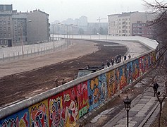
I added the two files shown at right to illustrate how Berlin has changed since its reunification. They show the same location, as evidenced by the signpost marking the intersection of Charlottenstraße and Zimmerstraße, and, in my opinion, deliver the full value of a thousand words in what they depict. I am certain, having taken the 1986 picture myself, that no arrangement of prose could have titillated my imagination nearly as much as it was upon seeing the changes in 2D.
They were subsequently removed for the following summarized reason: "one division pic is enough here". I would agree, except these images were not illustrating the division of Berlin, but instead: how drastically it changed upon reunification, and by all reasonable measure, how quickly as well. I think they improve the article, and am keen to know if others agree. Best regards.-- John Cline ( talk) 05:17, 3 July 2016 (UTC)
I think there should be an article on how "West" and "East" co-exist in the post-reunification era, and why it's perhaps a misnomer to talk about just "Berlin". There's a bunch of fascinating sources on this topic; here's a sample: -- Coin945 ( talk) 05:40, 26 January 2017 (UTC)
- https://www.washingtonpost.com/news/worldviews/wp/2014/10/31/the-berlin-wall-fell-25-years-ago-but-germany-is-still-divided/
- https://www.theguardian.com/world/2015/oct/02/german-reunification-25-years-on-how-different-are-east-and-west-really
- https://www.libertarianism.org/publications/essays/east-west-berlin-study-free-vs-controlled-economy
- http://www.visitberlin.de/en/article/living-in-a-divided-city-west-berlin
- http://fortune.com/2014/11/09/germany-east-west-economy/
This is from the ingress:
"Berlin is the second most populous city proper in the European Union and the seventh most populous urban area in the European Union. Located in northeastern Germany on the banks of the rivers Spree and Havel, it is the centre of the Berlin-Brandenburg Metropolitan Region, which has roughly 6 million residents from more than 180 nations, making it the sixth most populous urban area in the European Union."
So its the seventh most populous, then in the next sentence its the sixth. Seems both is based on the same source and the same year. I don't read French so I can't say what is right, but it should be corrected. Ulflarsen ( talk) 12:33, 1 August 2017 (UTC)
- So fix it! That's a nine year old dead link with no archive. You'll need to find a new source, start with the List of urban areas in the European Union page, which lists it in either seventh or third place, depending how you look at it... -- IamNotU ( talk) 15:01, 2 August 2017 (UTC)
{{geodata-check}}
Be aware! This edit might anger or frustrate the reader because the issue it addresses is so minor it could be called irrelevant. I would have edited the article myself, but unfortunately I don't understand how to obtain coordinates from the source used in all articles on cities.
The following coordinate fix is needed for Berlin:
- The coordinate on the page is located outside the city borders.
The following coordinate fix is needed in general:
- Coordinates are presented in all articles on cities. It should be noted why this exact location is chosen. Coordinates represent a point (non-dimensional) on the earths surface (two dimensional). This raises the question: "What point within the area covered by the city is chosen coordinate?". Does it represent location of some important building, or the cities historical or geometrical center, etc?
— CreatorOfYellow ( talk) 21:08, 27 September 2017 (UTC)
- I've changed the coordinates to reflect a point nearer the "geometrical center" of the city. The center, either the geographical center or a "business center", is usually where we put the coordinates of a settlement, although there are some exceptions in special cases. And we try to avoid too much precision relative to the place's size. Deor ( talk) 21:35, 27 September 2017 (UTC)
There's been a photo of the East Side Gallery in the lead photomontage since at least February 2015 (though not always the same photo). A few weeks ago, it was replaced with a photo of a monument at the Berlin Wall Memorial. Several people have tried to put it back, but the editor always reverts them. I'd like to discuss some kind of consensus about it. Which site do you prefer, and which photo?
Personally, I support the East Side Gallery as being a world-famous emblem of Berlin. The Berlin Wall Memorial is important in its own way, but just doesn't have that kind of status. For the photo, I'd like to see one of the more well-known artworks, ideally from before the fence that's now there. Some suggestions:
-

-
 The work of Thierry Noir, higher resolution.
 -
 Older version - was already in the photomontage for two years
 -
 Work by German artist Jim Avignon

_3.jpg)
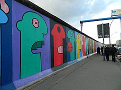
The first is one of the most famous, and the only work with its own Wikipedia article. I especially like the couple kissing in front of the mural. Thierry Noir is the first artist to be known for painting the wall, having done so since the mid-80s, and his figures are recognizable around Berlin; these two photos were both previously in the photomontage for some time, so already have support. There are of course other possibilities... -- IamNotU ( talk) 17:08, 12 February 2018 (UTC)
- "Several people" was you and an IP. Whatever - we are not voting here. The East Side Gallery claims to be a Berlin Wall Memorial but since there is an official Berlin Wall Memorial that represents a real historical accurat wall section with "Todesstreifen" aswell as a documentation centre, a memorial and a chapel in memory of the victims of the wall, your beloved Gallery is less relevant for the Article Berlin. As i already pointed out in an earlier discussion (which you deleted) on your ( IamNotU) Talkpage, the East Side Gallery is just a collection of wall parts with Graffitii. Maybe that is the reason why they called it "Gallery" and the other place is called "Memorial"? Btw. there are also many other Galleries in Berlin. For example the Neue Nationalgalerie. In case you want to see some art you better go check out some original Picasso there instead of "some kids Graffiti" on an old dirty concrete wall from the 60-80s. Anyway, the East Side Gallery is not "world famous". The Berlin wall certainly is. Berlin is a city in the center of world history in good and bad. Its full with famous places. They keep making historic movies there. Famous ones! Also because something was in the Article for a long time is not a reason to keep it there if something better is added instead. -- Kharon ( talk) 20:59, 12 February 2018 (UTC)
- There is no claim that the East Side Gallery is a memorial, so I don't consider that argument relevant. You have reverted three different people, me, 73.243.20.37, and InfinitePS. The fact that there were several previous versions of East Side Gallery photos from other editors, and that it has been the status quo for more than two years, indicates to me a basic consensus about it. I don't think your change is an improvement, but thanks for sharing your point of view. -- IamNotU ( talk) 21:39, 12 February 2018 (UTC)
- It was even a needed improvement, else i would not have changed it. I also do not understand why some concrete walls with (mostly silly "teenygangsta") graffiti on it makes a good picture representing Berlin, since you can find these in every major city around the world, except in china or saudi arabia, today. Since its clearly LESS relevant and specific to Berlin than the Berlin wall and its history and your only argument is "status quo for more than two years" i can only conclude its objectively an improvement. I even gave you a source ( [5]) with a ranking of the cities Landmarks by visitors which you completely ignore. You only cherrypicket one side-argument you could easily counter from my answer. Dont thank me for sharing my point of view if you actually ignore it! -- Kharon ( talk) 18:14, 13 February 2018 (UTC)
- Btw. the "East Side Gallery" is actually completely fake! The "East side Gallery" as the name hints is actually the socalled "Hinterland" wall, the other wall, facing the east Berlin side, which was never painted by artists or decorated with graffiti in the time of the separation of West and East Germany.
-
 There where actually 2 walls
 -
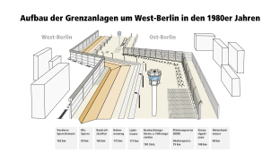 West Berlin wall, "Todesstreifen", East Berlin "Hinterland" wall
 -
 "Hinterland"-wall. No Graffiti! No "art"!


- The socalled "wall" was actually 2 walls with a minefield, shooting traps, fences and watchtowers on the socalled Todesstreifen inbetween. The painted wall was ofcourse only the other one that faced West Berlin. Its a historical lie! That exact wall segment, claimed to be the longest still existing original wall section, is in deed part of the original border construction but that wall never got painted on by "artists and free people" in its time, like the west side wall. In fact some artists started after(!!) the Wiedervereinigung to build a copy painted wall and called it "East side Gallery". In my view kinda like the Paris Las Vegas-Casino made their copy of the Eifeltower. -- Kharon ( talk) 21:49, 13 February 2018 (UTC)
People, people! This is a city article, not a mere history or tourism article. We now have 3(!) memorials in the lead collage, with the wall monument, Holocaust memorial and Checkpoint Charlie. That's way too much. One should be sufficient. I opt to restore this version (including this ESG photo), it has been stable and represented various aspects of the city without any POV tendencies. Thank you. -- Horst-schlaemma ( talk) 13:48, 15 February 2018 (UTC)
- Well Berlin is a city of monuments. Naturally because it was and still is a center of somuch History and the German capital. Besides the socalled East Side Gallery claims to be a "Denkmal", aka Monument aka Memorial, itself, so your argument of switching back to that because there are to many memorials makes no sense. On top Checkpoint Charlie is not a monument/memorial but just a world famous Landmark, so your math looks wrong. Nomatter, Monuments and Memorials are the Landmarks of cities with a long history. Additional, as i already pointed out, if any "Gallery" in Berlin should be mentioned or "pictured", it should be the Neue Nationalgalerie or the Museum Island or the Alte Nationalgalerie there instead of your prefered East Side Gallery. When i began editing the article i added the Berlin Victory Column, called"Goldelse" by the people of Berlin, but it was reversed. Last but not least even the Fernsehturm Berlin is a monument (little known, to Sputnik 1), which makes your math look right again but also shows how wrong your argument of "to many monuments" really is. -- Kharon ( talk) 16:20, 15 February 2018 (UTC)
- I agree with Horst-schlaemma's analysis and proposal, thanks for making it. To be accurate though, that specific version had not been stable, but is based on previous stable versions, offered as a compromise in order to overcome some problems. See my reply to InfinitePS below, for a comment about how and why it was arrived at. Also the caption needs to be updated. -- IamNotU ( talk) 11:29, 16 February 2018 (UTC)
- Oh, I just realized the link is to a different ESG photo than is in the linked revision. I had thought about Berlin_Wall6331.JPG which had also been in the article for some months, prior to the Mauricio Macri one. The older one, East_Side_Gallery.JPG, is a little low resolution (if you click on it) and the white balance is a bit off, it's a bit yellow. So you mean the second version here:


- I found a better ESG photo on Flickr and uploaded it. It's basically an upgraded version of the previous ones, with better composition, good color and resolution. I put it along with the earlier Oberbaumbrücke photo, in the version on the right. So that's now exactly the same as the last stable version that InfinitePS had restored, except with the problematic "Mauricio Macri" photo replaced by the new one. Having read through all the comments and arguments, I'm going to put this into the article on the basis that there's a consensus to show these subjects (City West skyline with Memorial Church, Brandenburg Gate, East Side Gallery, and Oberbaumbrücke), a consensus to not include the Berlin Wall Memorial, Holocaust Memorial, or Checkpoint Charlie at this time, and that these specific photos or substantially similar ones fulfill the aim of the consensus. -- IamNotU ( talk) 03:03, 22 February 2018 (UTC)
We have to understand that no one is going to be 100% satisfied with any single photomontage of Berlin that we can come up with-- for a city with so much diversity in sights and monuments, this is quite impossible. Therefore we should strive to find the best balance of selection for this montage, while taking into account all points of view--- it should be a carefully constructed overview of the diversity in architecture, cityscape, and history of the city. I am still convinced that the montage as it stood for many months prior to the more recent edits had best achieved this; its long standing lifespan confirms this. The previous montage had a good balance of monuments/sights from various eras that are now no longer represented, such as the Kaiser Wilhelm Gedaechtniskirche (now nowhere to be seen in the entire article) and the Oberbaum bridge.
As to the Berlin Wall, I agree that it should somehow be included-- that said, the East Side Gallery, regardless of its status as a memorial or not, has always looked the best in the montage, while also offering an element that represents the important aspect of street art culture in Berlin. It is understandable that many are critical of this aspect of Berlin culture, and that this is not unique for Berlin, per se. But, being able to cover both the historical element of the wall and the significant countercultural element of Berlin culture (which grew out of the object on which it is displayed) in one photograph for the montage has always been the most representative choice IMO. Also, from a simply pragmatic point of view, it is much easier to acknowledge the wall in a small photomontage when it is colorful, as opposed to a brown square with some frames of even tinier photographs in them. The montage therefore needs to not only be representative, but also chosen in a way that viewers can identify the important elements without having to enlarge the individual images.
InfinitePS (
talk) 04:35, 16 February 2018 (UTC)
Also, I do agree that certain monuments, like the Siegessaeule, Holocaust Memorial, and a more representative photo of the Berlin Wall Memorial should be highlighted somewhere else in the article. I have found it consistently appalling that there is not a single image of the Siegessauele anywhere in the article, an important secondary landmark. Also after the current edits of the gallery, the Kaiser Wilhelm Gedaechtniskirche is also nowhere to be seen, as this was the only place where it was shown. InfinitePS ( talk) 04:49, 16 February 2018 (UTC)
- @ InfinitePS, thanks for your insights. I would support restoring the last stable version from 12 July 2017 as you've done, for the reasons you've given, but there's one problem. As Kharon correctly pointed out, the filename and description in Spanish: "Berlín, Alemania. 26 de abril de 2012. El jefe de Gobierno de la Ciudad de Buenos Aires, Mauricio Macri, visitó hoy el monumento que recuerda a las víctimas del Holocausto en la ciudad de Berlín" appears to misidentify the East Side Gallery as the Holocaust Memorial. So I agree it shouldn't be in the article in that condition. At the time, I offered a similar photo to replace it with this edit, which also replaced the Oberbaumbrücke photo with a similar one, to match the size. An alternative could be to duplicate the photo with Mauricio Macri (his presence does make it more interesting) with an accurate description and filename. I would also support restoring to the previous stable version before that, from 9 May 2017, which is the same except for the East Side Gallery and Oberbaumbrücke photos. Personally I do prefer the earlier East Side Gallery photo with Thierry Noir's work. However, I think that the later Oberbaumbrücke photo was an improvement. But using it with the older East Side Gallery photo also creates a size mismatch... so my compromise was to use the earlier East Side Gallery photo with the Oberbaumbrücke photo that makes the size match everything else. That's the version here, that Horst-schlaemma has also proposed above to use. Sorry it's a bit complicated... what do you think? -- IamNotU ( talk) 10:55, 16 February 2018 (UTC)
- Ah wait, I think Horst-schlaemma maybe meant something else, see above... -- IamNotU ( talk) 13:45, 16 February 2018 (UTC)

- "Fangfrage": Do any of the other editors arguing here actually live in Berlin? Cause i do and i keep wondering about leadin picture choices like the Oberbaumbrücke, which i actually dont know and never heard of. Not as a claimed Landmark and not a tourist attraction. Are you into historic Buildings? What about the Spandau_Citadel then? Thats shurely more important than one of the 1000 Berlin Bridges. Its even mentioned as a "popular tourist spot" and allot of events happen there. I am even more shocked that size match of images is a more important argument to some here than what 1 Million tourists each year want to visite. -- Kharon ( talk) 16:09, 16 February 2018 (UTC)
I think any of the above gallery suggestions are well composed.-- To reply to
Kharon, I understand we're all very particular in how we want this article to represent the city, but please keep in mind that the gallery shouldn't just be focused on tourist sites. I have spend quite some time in Berlin and have a solid understanding of how people of different backgrounds might perceive the city, including residents, tourists, historians, architects, artists, etc. Berlin is not just defined by those who live inside of the city. In fact, nowadays, the boundaries are blurred between those who actually live in Berlin and those who simply visit for a longer term. I'm still flexible in my own impressions and acknowledge other arguments, but I do think that simply placing a bunch of post-WW2 memorials in the main gallery is not representative of the complexity of the city as a whole.
Yes, the Oberbaumbruecke may not be the most iconic sight in Berlin, but given that the Red Rathaus is already visible in the skyline view from Tiergarten, it is the only other worthy site that highlights the ubiquitous red brick architecture, while also including a view of the Spree (no where else seen in the gallery), and while also being a symbol of the reunification of the once divided city (aside from the Brandenburg gate)-- I also think that an additional depiction of a U-bahn on the bridge would add yet another important element nowhere to be seen in the montage (i.e. the primary mode of transport for many within the city)- the fact that the Oberbaum bridge can cover so many aspects of Berlin in a single photograph, which none of the others address, makes it a superior choice regardless whether everyone in the world has heard about the bridge or not-- it is a reprententation of Berlin and defines the city in a concise and all-encompassing way.
73.243.20.37 (
talk) 08:35, 17 February 2018 (UTC)
- I disagree. We should offer sources that prove or include very strong evidence about our picture choices being the best representation of the city. Your arguments for the Oberbaumbruecke are the opposite - your pov, an essay, a makeup. Tourist visitornumbers are ofcourse not the main focus but a very strong prove that some location is representative, especially if its not the central station but a place that represents a part of the cities history. Especially regarding the cities history in WWII and its central role in the Holocaust (see Wannsee Conference) the Memorial to the Murdered Jews of Europe is a major representation of the city and build by the city for exactly that reason. Again! Build by the city(!) for exactly and only representing its history in a way the city views as appropriate! How dare you to throw that out of the lead and argue about your personal view or like Horst-schlaemma argue its one to many memorials. Why you think Berlin build that memorial in its city center so every visitor will see it? The East Side Gallery was not(!) build by the city! -- Kharon ( talk) 10:25, 17 February 2018 (UTC)
- Please inform yourself before stating obvious fallacies, Kharon. First of all, the Holocaust memorial wasn't built by or for the city of Berlin, it was built by the Denkmal foundation and the German federal government - by German taxes, agreed on by the Bundestag. It also isn't thought to represent Berlin or the connection to Berlin, but Europe as a whole and all murdered jews (in WW2). Thus it shouldn't be interpreted as Berlin specific, Berlin just "happens" to be the German capital. It's misplaced in the lede in various ways, even though it's located close to Brandenburg Gate (which is both Berlin and Germany specific).
- Concerning IamNotU's proposals, I'm finde with either version (1 or 2). -- Horst-schlaemma ( talk) 10:46, 17 February 2018 (UTC)
- The Memorial to the Murdered Jews of Europe is just a few steps away from the Brandenburg Gate at the Hannah Arendt Street. The Initiator Lea Rosh is a Berliner. She lives and works here and she was born here, in Berlin. Its common that a non-profit membership organization is founded to plan, build and then supervise such projects. The foundation is in Berlin. The German federal government and the Bundestag are infact Berliners. Our Chancellor Angela Merkel lives and works in Berlin. Our President of Germany Frank-Walter Steinmeier lives and works in Berlin.
- It seems to me in this case the german proverb "den Wald vor lauter Bäumen nicht sehen" ("not recognizing the Forrest standing between all these trees") is a "bullseye" strike into your argument. This additionally proves my earlier argument: A Berliner would most likely know all this (and agree to my picture choices without long discussions). -- Kharon ( talk) 03:48, 18 February 2018 (UTC)
I apologize for the length of the following, for such a seemingly small issue as a few photos. But I feel it's important to follow the process of consensus based on accurate information and arguments, especially for the lead of this major article. Kharon has asserted that three of the six photos are inappropriate and needed to be removed from the photomontage - indeed from the article altogether. With regard to the reasoning given for this, I offer the following fact-checks:
The East Side Gallery was an initiative in 1990 of the newly-unified national artists' organizations of East and West Germany, the VBK and the BBK. It was the first official gesamtdeutsch art project of post-wall Germany. Over 100 recognized artists were invited to create original artworks on the section of unpainted eastern wall. According to them it is "understood as a monument to the fall of the Berlin Wall and the peaceful negotiation of borders and conventions between societies and people", and has more than three million visitors annually. [1] The murals were described by Deutsche Welle as an "artistic response to one of the most important moments in history". [2] The artworks were commissioned as one of the last official acts of the Council of Ministers of the GDR, and a year later the gallery was granted Denkmalschutz, heritage-protected landmark status, by the new government of Berlin. The murals and gallery were repainted and renovated in 2009, with the involvement of nearly all the original artists, by the city of Berlin, at a cost of over two million Euros.
Several books have been published, and a feature-length documentary film produced, about the artworks and the gallery. According to Deutsche Welle, the "paintings such as Dmitri Vrubel's "Bruderkuss" between Soviet leader Leonid Brezhnev and GDR leader Eric Honecker or Günther Schaefer's "Vaterland," blending the German and Israeli flags have become iconic". [2] [3] High-quality images of the paintings can be found here. With this in mind you may judge for yourself the accuracy of Kharon's objections to the East Side Gallery photo as being inappropriate and needing to be removed, on the basis that it is simply some old dirty concrete with nondescript "teenygangsta" graffiti; that it fails to be a serious memorial to the dead (which no one has claimed it to be); that a gallery of street art in East Berlin, commemorating the fall of the wall, is "completely fake" because it failed to exist before the wall fell; or that it was not built by the city.
With regard to the other two photos that have also been removed: For more than a century, Oberbaumbrücke has been the longest, most well-known, and most picturesque bridge in Berlin. It began in 1902 to carry the first Berlin U-Bahn line across the Spree River, which it continues to do today. It is the official emblem and landmark of the central district of Friedrichshain-Kreuzberg, and an important symbol of a reunified Berlin. The skyline of the western downtown/Zoo area, with the article's only image of the Kaiser Wilhelm Memorial Church, needs no introduction. Again you may judge for yourself the accuracy of the objections to both of these photos as being inappropriate and needing to be removed, on the basis of the surprising claim of a Berliner having never heard of them - an argument which is in any case not valid even if true.
My own thoughts are very much in line with those already well-articulated by the others: Horst-schlaemma, InfinitePS, and 73.243.20.37. The selection of the lead images will always be to some extent subjective, as it's not possible to find a reliable source that says "these six images are the objectively correct representation of Berlin." There are many factors to be considered in choosing the subjects, not only popularity with tourists, or official government status. Sometimes a photo of a lesser-known subject may be included for diversity as well as for being particularly scenic or picturesque, for example the Unisphere in the excellent New York City article's photomontage. The choice must be balanced and follow the neutral point of view policy, but each individual editor will have their own point of view about how best to accomplish that. For that reason it is especially important to follow the process of consensus among editors.
There are dozens of subjects that could conceivably be illustrated. The Brandenburg Gate and the Reichstag are nearly unquestionable. The downtown skyline - typical for every major-city article - with the TV Tower, and that of the western side with the Memorial Church, are also I think essential. The church is a fitting symbol of grief over the loss of lives and destruction, on all sides of the war, and the message to never forget. But I agree with Horst-schlaemma's view that adding additional sombre war memorials such as the Memorial to the Murdered Jews of Europe, and the Window of Remembrance picturing those who were killed at the Berlin Wall, would be too much. Such an overweight representation also might not be consistent with the principle of "least shock value" in lead images, explained in the manual of style, nor with its "strive for variety" advice.
Although a case could possibly be argued for replacing the East Side Gallery or Oberbaumbrücke with Checkpoint Charlie (or any number of other subjects) I feel they are both the stronger candidates. I think it is natural to represent the Berlin Wall. But given the reasoning in the preceding paragraph, I feel the East Side Gallery better emphasizes the hopefulness and creative energy surrounding its fall and the rebuilding of Germany, and gives a counterpoint to the Memorial Church, as well as giving a nod to Berlin's reputation as a city of artists. Finally, the view up the Spree river, showing the Oberbaumbrücke, is both scenic and historical, shows an alternative to the "blockbuster" tourist attractions, and is not in any way out of place. So far I have not seen any proposal or persuasive argument for a replacement of any of these that would clearly improve the article. -- IamNotU ( talk) 02:55, 22 February 2018 (UTC)
- Actually the much rewarded NYC photo collage is the prime example of how it should be done. These photo collages need to be representative of the city without over-politicising the matter. Paris and London just as well, they also have their huge, huge historical flaws and faults, but no one thinks of derailing their collage with guilt memorials and insignia of horror. Only Berlin so far seems to evoke the need to do something like that, which shouldn't be tolerated in a neutral encyclopedia. We've seen great proposals of IamNotU to follow and to keep. -- Horst-schlaemma ( talk) 09:02, 22 February 2018 (UTC)

- @ Horst-schlaemma: "derailing their collage with guilt memorials and insignia of horror."?? That is exactly the view of some radicals of the new german alt-right movement. Björn Höcke to be precise. I am all for free speech - dont get me wrong - even for Mr. Höcke, but fortunately that is still definitely not a majority view. Neither in germany nor elsewhere.
- @ IamNotU: You needed 3 pages of spinning for your attempt to ridicule my arguments. I never wrote the East Side Gallery was inappropriate. Its just completely fake(!) in what it poses to be as i proved with evidence and sources. Las Vegas also has fake landmarks, as i pointed out. That is ok for Las Vegas i guess... Fortunately Berlin has so many real, original unique and historic Landmarks. We could easily fill 5-6 additional galleries with pictures. Its not about inappropriate, its about the best choices. Old concrete walls from the wrong side, with a copy of the art on the Berlin wall in the wrong place? How does that represent the real Berlin? I want to show the real Berlin. So many interesting places, somuch art. Do you know Reinhold Begas? Have you seen the front of my userpage? -- Kharon ( talk) 22:33, 22 February 2018 (UTC)
- You completely misunderstood that Kharon. Such memorials are purposefully created as "guilt memorials" and I don't see anything wrong with that. All I'm saying is that it's not a general representation of the city itself, rather the country and its culture. Thus I see it as misplaced in a Berlin collage at the lede. Cheers, Horst-schlaemma ( talk) 09:29, 23 February 2018 (UTC)
- Like the Statue of Liberty is an icon of independence and liberty of/in the united states, that became the most famous landmark of New York? Just as a sidenote, i bet Reinhold Begas put more work into any of his complementing sculptures than all artists of your beloved East Side Gallery put in together. The city is full with art and landmarks.
-
 Bismarck-Nationaldenkmal, Berlin Tiergarten.
 -
 your choice.
 -
 Neptunbrunnen infront of the Rotes Rathaus.
 -
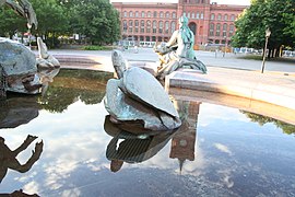 Complementing Turtle, Neptunbrunnen.

.JPG)
- Die Zitadelle at Spandau is nice, but Landskrona Citadell is even better preserved, from the moats' point of view at least. There is one well preserved in Belgium also (Antwerpen ?). Kastellet at Copenhagen also worth mentioning, and with a rather central location. I like the gallery above. But I would like to have added both Unter den Linden and Kurfürstendamm - too, not instead. Famous streets. Boeing720 ( talk) 23:42, 16 August 2018 (UTC)
- with all due respect, but you can find this sort of scenery in any German city, especially in the failed industry zones at the outskirt of a German city. The graffiti is a urban youth-culture phenomenon in Germany.-- MedRobo ( talk) 20:55, 9 December 2023 (UTC)
References
- ^ "East Side Gallery Berlin". Künstlerinitiative East Side Gallery e.V. Retrieved 2018-02-13.
- ^ a b "East Side Gallery artists battle over rights and compensation". Deutsche Welle.
- ^ "Berlin's East Side Gallery on film". Deutsche Welle.
I'm certain to have seen 1701 as the year Berlin became Prussia's capital before. But can anyone find a source ? Had a look in our Prussia article. The year is 1701 , but no source there either. A German encyclopedia or book on the history of Berlin perhaps ? (Why the American flag, by the way ? Germany is after all not very far away from England - and I think we should use real English here) Boeing720 ( talk) 23:27, 16 August 2018 (UTC)
- Maybe check out our article Margraviate of Brandenburg and Holy Roman Empire for a grand sketch of the european history and later the part of Berlin in it, starting with Charles the Great in the year 800. There was allot of turmoil, many small and some bigger wars in between which makes it hard to pin down the history of Berlin appropriately to single events and dates. I have no clue what flag you are referring to. -- Kharon ( talk) 03:22, 22 August 2018 (UTC)
I have added figures for "other" totals - calculated by subtracting the figures for the countries in each region that are displayed in the table, from the total given for each region in the source (Europa zusammen pg. 18, Amerika zusammen pg. 20, Asien zusammen pg. 21). 212.39.89.245 and XodoX, I appreciate your contributions to updating the table with new figures. In the future it would also be good if you or others are updating the table, to update the "other figures as well. Otherwise a skewed picture of the demographics is given, with over 235,000 people missing... -- IamNotU ( talk) 13:57, 23 February 2019 (UTC)
Why is not the population density listed as under most other major cities in Europe?
/info/en/?search=List_of_European_Union_cities_proper_by_population_density
The fact that Berlin is a vast city by area is known. As every city can define it´s borders to it´s own liking. What is the reason for the population density not to be shown? Most peculiar. — Preceding unsigned comment added by 83.150.9.77 ( talk) 18:57, 7 November 2019 (UTC)
- WP:SOFIXIT. This might help: https://www.stadtentwicklung.berlin.de/umwelt/umweltatlas/edn606_01.htm -- IamNotU ( talk) 14:57, 8 November 2019 (UTC)
Kharon, in this edit: [6], has changed the "Climate" section from:
Berlin has an oceanic climate – ( Köppen: Cfb), [1] the eastern part of the city has a slight continental influence...
to:
Berlin has an oceanic climate – ( Köppen: Cfb), [2] because Berlin is a very water rich federal state. [3] The eastern part of the city has a slight continental influence...
There are multiple issues with this edit, the main ones being:
- The added statement fails verification in the added source. The cited article is about Berlin's "rich" groundwater and drinking water resources. It does not mention Berlin's oceanic climate, nor Köppen climate classification, nor climate in general.
- The added statement is false. The fact that Berlin has an oceanic climate is clearly not in any way because of being rich in groundwater resources.
For these reasons, I removed the added statement, in accordance with WP:V and WP:NOR. Rather than just delete the reference, I moved it to the "Topography" section and added some information about groundwater from it. See this edit: [7].
In addition, the citation's URL pointed to a Google Translate machine translation of the article. It's my understanding that the consensus reached in this rfc: Wikipedia:Village pump (policy)/Archive 130#Links to Google Translate, which specifically addressed this question, was that citations should not link to Google Translate. I changed this, and made some other corrections to the citation (wrong website, poorly-formatted title, etc.).
Kharon reverted my edit as "nonsense", reinstating theirs: [8]. I'm asking for others' opinions and a consensus about this. In the meantime, I have restored the article to the previous status-quo, pending outcome of this discussion. -- IamNotU ( talk) 23:51, 1 December 2019 (UTC)
Pinging Kubaski, who has made significant contributions to the "Climate" section recently, and to that sentence. Also pinging 2601:188:180:F040:E973:7D9D:B169:D20E ( talk · contribs · WHOIS), who deleted part of the same sentence earlier that day, without explanation, could you explain why? -- IamNotU ( talk) 00:26, 2 December 2019 (UTC)
- I cited the chapter 2 headline of my SOURCE ("Berlin is a water rich federal state") with "because Berlin is a very water rich federal state" to clarify why Berlin is categorized as "oceanic climate" no matter it is in fact not near any ocean.
- Also i don't care about who thinks what about Google-translate-pages as reference in this case as it is a nonsense complacently argument that actually messes up the source instead of showing the connection (which you consequently missed on top). -- Kharon ( talk) 03:06, 2 December 2019 (UTC)
References
- ^ "Berlin, Germany Köppen Climate Classification (Weatherbase)". Weatherbase. Retrieved 2019-01-30.
- ^ "Berlin, Germany Köppen Climate Classification (Weatherbase)". Weatherbase. Retrieved 2019-01-30.
- ^ "hauptstadt-auf-dem-trockenen". Weatherbase. Retrieved 2019-11-30.
I wonder why the article lacks information about the role the city plays within histories of genocides (the Holocaust), racism (as the capital of Germany) and European White Supremacy in general. Instead, the article seems to paint a rosy picture of a post-race paradise for a reason that I could only attribute to self-promoting marketing-oriented Berlin-based and German Wikipedia editors. -- 2600:1010:B048:BD91:848E:37DE:A1BA:A8C8 ( talk) 03:31, 4 March 2020 (UTC)
Changed the intro a bit. Heading east of the confluence of Elbe and Saale, one passes south of Berlin, so the claim of Berlin being to the east of the Saale is a bit tall imho. North to Northeast would be more like it, but given the geography, not east. Keeping in mind that banal facts do not have to be referenced. Berlin is commonly referred to as being east of the Elbe, if a riverine reference is used. Referring the location relative to the Saale as a main description is OR, if not by the author, then by the source. Gotta go now - have to mention in the article of Edinburgh that place's north of the Thames. If you catch my drift. No offense intended, -- G-41614 ( talk) 08:20, 11 March 2020 (UTC)
This structure may be iconic, but of european history as suggested in the text? I wouldn't be surprised if there were a lot of europeans who'd beg to differ. As a symbol of change after the Cold War, it would be an icon of global history, and it certainly is such regarding to german history. But explicitly european? Hm. Who said that? Regards, -- G-41614 ( talk) 06:11, 21 May 2020 (UTC)
- As there is no reference, you can rephrase it, if you like. -- GodeNehler ( talk) 05:26, 24 May 2020 (UTC)
When I was in Germany a couple years ago it only got as far as astronomical twilight, it was astronomical twilight at solar midnight rather than complete darkness. Does Berlin get complete darkness at winter solstice?, Berlin's latitude is 52.5 degrees therefore it falls in astronomical twilight on the summer solstice, complete darkness doesn't occur within 41.5 degrees of either pole on summer solstice.
-- 98.31.29.4 ( talk) 00:22, 16 October 2020 (UTC)
- How does this relate to the article exactly? If you want to ask a specific scientific question, then please visit Wikipedia:Reference desk/Science instead. Best, ɴᴋᴏɴ21 ❯❯❯ talk 00:31, 16 October 2020 (UTC)
The following Wikimedia Commons file used on this page or its Wikidata item has been nominated for deletion:
Participate in the deletion discussion at the nomination page. — Community Tech bot ( talk) 19:51, 17 June 2022 (UTC)
On the side panel Population of city is missing even though it shows on the edit page. 104.3.143.81 ( talk) 14:56, 31 January 2023 (UTC)
I don’t edit Wikipedia so apologies if this isn’t proper procedure but in the 20th-21st century section of the page it says Hitler announced the results of his design contest in 1910. Not sure what the real year is but it should be sometime in the 1930s. 46.183.103.8 ( talk) 18:19, 27 May 2023 (UTC)
This article has around 180 "Lua error: not enough memory" errors at the bottom, currently starting in Berlin#References. I asked about the issue at Module talk:Mapframe#Lua error: not enough memory pointing out that it is due to the complex {{ maplink}} in the infobox. A reply suggested removing the Germany map. Any thoughts on that? WP:VPT could be used to ask if other solutions might work. Johnuniq ( talk) 04:38, 23 July 2023 (UTC)
- I just removed the Germany map and it has resolved the problem. The article HTML source contains a NewPP report with "Lua memory usage: 33158319/52428800 bytes" meaning the memory used is 19MB less than maximum whereas before it was over the maximum. Johnuniq ( talk) 08:22, 27 July 2023 (UTC)
The German Wikipedia and official sources give the area as 891.7 square kilometers. What's going on here? 2A02:8109:B60F:B300:60E3:E2C4:BB5:E05A ( talk) 22:27, 9 November 2023 (UTC)
- Done Kgfleischmann ( talk) 20:03, 10 November 2023 (UTC)
- Wikipedia articles that use American English
- Delisted good articles
- Old requests for peer review
- B-Class vital articles
- Wikipedia level-4 vital articles
- Wikipedia vital articles in Geography
- B-Class level-4 vital articles
- Wikipedia level-4 vital articles in Geography
- B-Class vital articles in Geography
- B-Class Germany articles
- Top-importance Germany articles
- WikiProject Germany articles
- B-Class WikiProject Cities articles
- WikiProject Cities core articles
- B-Class WikiProject Cities national capital articles
- WikiProject Cities national capital articles
- All WikiProject Cities pages
- B-Class Middle Ages articles
- Mid-importance Middle Ages articles
- B-Class history articles
- All WikiProject Middle Ages pages
- B-Class Olympics articles
- Low-importance Olympics articles
- WikiProject Olympics articles
- B-Class former country articles
- B-Class Holy Roman Empire articles
- Unknown-importance Holy Roman Empire articles
- Holy Roman Empire task force articles
- WikiProject Former countries articles
- B-Class geography articles
- High-importance geography articles
- WikiProject Geography articles
- Wikipedia pages with to-do lists
| This is the
talk page for discussing improvements to the
Berlin article. This is not a forum for general discussion of the article's subject. |
Article policies
|
| Find sources: Google ( books · news · scholar · free images · WP refs) · FENS · JSTOR · TWL |
| Archives: 1, 2, 3, 4, 5, 6, 7 |
|
| This article is written in American English, which has its own spelling conventions (color, defense, traveled) and some terms that are used in it may be different or absent from other varieties of English. According to the relevant style guide, this should not be changed without broad consensus. |
|
| Berlin was one of the Geography and places good articles, but it has been removed from the list. There are suggestions below for improving the article to meet the good article criteria. Once these issues have been addressed, the article can be renominated. Editors may also seek a reassessment of the decision if they believe there was a mistake. | ||||||||||||||||||||||||
| |||||||||||||||||||||||||
|
| This It is of interest to the following WikiProjects: |
|||||||||||||||||||||||||||||||||||||||||||||||||||||||||||||||||||||||||||||||||||
| ||||||||||||||||||||||||||||||||||||||||||||||||||||||||||||||||||||||||||||||||||||
|
|
|
Daily pageviews of this article
A graph should have been displayed here but
graphs are temporarily disabled. Until they are enabled again, visit the interactive graph at
pageviews.wmcloud.org |
Please don’t confuse the Berlin metropolitan area as Wikipedia defines a Metropolitan area with the “Capital” region as some officials/agencies in Berlin-Brandenburg would like to define the region. According to Wikipedia: “A metropolitan area, metro area or metro is a region consisting of a densely populated urban core and its less-populated surrounding territories, sharing industry, infrastructure, and housing” – note that farming and other distant rural areas are not included. The metro area is shown for example as the yellow parts of the maps and by the lists of towns. Personally, I would also say it’s the area you can reach by public transport with a Berlin ABC ticket. The given reference http://www.berlin-brandenburg.de/daten-fakten/ also refers this as “Berliner Umland”.
The “Capital Region Berlin-Brandenburg” is a construction that government agencies are trying to push, but it simply includes all of Brandenburg with Berlin. It is true, that in the wider sense Brandenburg’s economy is generally, but not exclusively, oriented towards Berlin. Some day they may even become politically united. However, it is stretching it a bit far to say that vast rural areas such as the forests of the Uckermark or the swamps of the Spreewald belong to the metropolitan area of Berlin. It would be like saying all of Connecticut is part of the Hartford metropolitan area.
So, please adhere to the definition set by Wikipedia and do not follow some megalomaniac political redefinition. Alandeus ( talk) 13:35, 7 February 2013 (UTC)
- Hello :) It is not up to us or Wikipedia to define Berlin metropolitan, that is up to The state of Berlin and Brandenburg, or the German Federal State. If the official numbers are 6 million then it is 6 million, we are not the judgers of that, we follow the official figures, and fact is that Berlin metropolitan are Berlin-Brandenburg. and the links clearly defines the Berlin-Brandenburg as Berlins metro area. — Preceding unsigned comment added by 86.52.81.168 ( talk) 18:25, 7 February 2013 (UTC)
- I’m sorry User 86.52.81.168, but in the encyclopedic realm of Wikipedia, its definitions are quite sound (see above). If some well-meaning government officials for the Berlin/Brandenburg Metropolitan Region have a different idea of what a metropolitan area is, they are welcome to espouse something else on their own “official” websites, no matter how off the mark they are. What they are actually advocating is simply a much larger regional area with a real metropolitan area in the middle as a focal point. The faraway fields of Brandenburg only belong to the Berlin area in so far as that is where the Berliners get their vegetables from for example or where they go for a weekend getaway. Greetings from Berlin, yours Alandeus ( talk) 09:12, 8 February 2013 (UTC)
- Official definitions are all we need with reliable links, the figure of 4.5 mio people don't have any link, but the claims of 6 mio people does, so that is the guideline and what we can use as a reliable source.
- Wikipedia is not a place to make definitions, but a encyclopedia, to put reliable content. At least let's change the figure to include 6 mio people.
- But is must say that you don't recognize the official figures from the states of Berlin and Brandenburg plus IKM (Initiativkreises Europäische Metropolregionen in Deutschland) are not in the spirit if Wikipedia, where reliable sources are all we recognized. The German language site on Wikipedia Metropolregion Berlin/Brandenburg recognized the links, why not on the English language site? — Preceding unsigned comment added by 86.52.81.168 ( talk) 22:43, 8 February 2013 (UTC)
- Wikipedia is a place to make definitions. When reviewing Metropolitan Areas it must have a fundamental definition as a benchmark when collecting and comparing data from many different sources. Some “official” sites seem to make their area larger than what actual metropolitan are for whatever interests they may have. Sure, information from these sites is useful, but only insofar as it does not distort encyclopedic evaluation.
- About those 4.5 million inhabitants: The “Daten und Fakten zur Hauptstadtregion“ page ( http://www.berlin-brandenburg.de/daten-fakten/) has those population figures in the middle and at the bottom of the page: about 3.5 for Berlin, 900 thousand for the area around Berlin (“Berliner Umland”) and 1.6 million for the rest of Brandenburg. I’m sure these latter, more distant Brandenburgers would be appalled to be considered being part of Berlin. Alandeus ( talk) 10:01, 11 February 2013 (UTC)
- The same site say that "Berlin und Brandenburg bilden zusammen die deutsche Hauptstadtregion mit 6 million menschen" In English - "Berlin and Brandenburg together form the German capital region with 6 million people", fact.
- You write "more distant Brandenburgers would be appalled to be considered being part of Berlin" Personal feelings are not relevant, the States of Berlin and Brandenburg say it is Berlin metro area, then it is what it is, fact. — Preceding unsigned comment added by 86.52.84.231 ( talk) 18:13, 11 February 2013 (UTC)
- Dear 86.52.84.231: Back to basics once more: The quoted source says “Hauptstadtregion” or “capital region”. Granted, that is the whole region around the capital including all of rural Brandenburg. When Wikipedia talks about metropolitan areas, however, that is a concentration on exclusively urban areas and that is what we ought to stick to when evaluating the Berlin metro area, including the 4½ population figure. My opinion on the Brandenburgers, by the way, was not meant to be taken as a fact of course; it was just a tongue-in-the-cheek afterthought. Alandeus ( talk) 07:50, 12 February 2013 (UTC)
Hello Alandeus :) my point is that the only figures we have are the 6 million people, no source are mentioning 4½.
And recarding metropolitan areas, a metro area are not only urban, but can contain large rural areas who are afffected by the urban area in terms of commuting and influence.. As stated in Wikipedia's own site - A metropolitan area combines an urban agglomeration (the contiguous, built-up area) with zones not necessarily urban in character, but closely bound to the center by employment or other commerce. These outlying zones are sometimes known as a commuter belt, and may extend well beyond the urban zone.
Metro areas with large rural areas are common, here are some.
Seattle metropolitan area 3.5 mio people - 21,202 km2
Phoenix metropolitan area 4.2 mio people - 37,744 km2
Hamburg Metropolitan Region 5.2 mio people - 26,000 km2. — Preceding unsigned comment added by 86.52.84.231 ( talk) 12:07, 12 February 2013 (UTC)
- The quaint Brandenburg towns of Wusterhausen, Schwedt and Lübbenau for example are each about an hour’s drive from Berlin and are therefore not really in the defined ‘commuter belt’ of or otherwise ‘closely bound’ in a Berlin metro area, i.e. that yellow area on the metro area map. And although that 4½ million figure is not mentioned explicitly on the aforementioned source page, it is pretty easy to come to this total from the data provided there. And those other examples; maybe those need to be reexamined as well. Alandeus ( talk) 14:24, 12 February 2013 (UTC)
- The map you are mentioning are self made by a wikipedia user called Broadway, so the definitions on that map are not any official status. — Preceding unsigned comment added by 86.52.84.231 ( talk) 19:07, 12 February 2013 (UTC)
- Of course Broadway’s excellent map of the Berlin/Brandenburg Metropolitan Region is not “official”. It visualises perfectly well though the area as correctly defined by the rest of the Berlin/Brandenburg Metropolitan Region article. Please, 86.52.84.231 (are you from Berlin or Brandenburg?), get off the idea that everything must have or rely only on an official source. Alandeus ( talk) 09:50, 13 February 2013 (UTC)
- It seems that we are not going anywhere :) lets at least mentioning the 6 mio, when the official sources claims it. What about this line, "the Berlin-Brandenburg Metropolitan Region, whit a population ranging from 4,5 to 6 mio people according to different sources. — Preceding unsigned comment added by 86.52.84.231 ( talk) 22:19, 13 February 2013 (UTC)
- No need to muddle up or bloat the lead paragraph with references to differing sources. Various population figures can already be found in the Demographics section. For the sake of completeness though, I’ve added “The entire Berlin-Brandenburg region has a population then of 6 million.” there with reference to Hauptstadtregion Berlin-Brandenburg. Hope this is a satisfactory compromise. Alandeus ( talk) 09:04, 14 February 2013 (UTC)
West Berlin was not legally part of West Germany and to state that it was compromises the factual accuracy of this article. Paul Austin ( talk) 13:44, 29 April 2013 (UTC)
- Although the Allies maintained their role as the highest executive authority - West Berlin did de facto become a "Bundesland" of the FRG, and was represented in the Bundestag and Bundesrat. West Berlins' residents were citizens of the FRG. There is no need to go into depth about West Berlins' complicated legal status - at least not in the lead. After all, this article is about Berlin and not West Berlin. More detailed information is given in the appropriate section (History, 2.2 20th century) of this article.-- 77.181.5.160 ( talk) 17:58, 29 April 2013 (UTC)
- de facto and de jure are important distinctions. To include wrong information in the lede is not good. It is possible to simplify without distorting. 158.181.66.104 ( talk) 22:59, 16 June 2013 (UTC)
- "The constitution of West Berlin, as it came into force on 1 September 1950, maintained that West Berlin is a constituent Land of the Federal Republic, where the Basic Law of the Federal Republic is binding ... Under its 1950 constitution, West Berlin is a state of the Federal Republic..."Dorothy Elkins, T. H. Elkins, B. Hofmeister, Berlin: The Spatial Structure of a Divided City, 1988, p.40-41 [1] -- 82.113.99.196 ( talk) 16:41, 1 August 2013 (UTC)
In this article's second paragraph I find it stated that West Berlin was one of the states of the Federal Republic before the re-unification of Germany. In the 1980s I actually believed that to be the be the case. I know that Willi Brandt, who resided in West Berlin, served as chancellor of the Federal Republic before the re-unification. However, I also know that West Germany's laws allowed even citizens of East Germany to hold that office and others in West Germany, since they refused to recognize any distinction between different German citizenships. I think it was from reading Wikipedia's article on Germany's re-unification and its article on the Federal Republic that I came to think that Berlin was never incorporated in the Federal Republic until 1990. Is there a source for the assertion? Michael Hardy ( talk) 11:49, 1 August 2013 (UTC)
- West Berlin did de facto become a "Bundesland" of the FRG, and was represented in the Bundestag and Bundesrat. West Berlins' residents were citizens of the FRG. -- 77.181.244.33 ( talk) 16:07, 1 August 2013 (UTC)
- "The constitution of West Berlin, as it came into force on 1 September 1950, maintained that West Berlin is a constituent Land of the Federal Republic, where the Basic Law of the Federal Republic is binding ... Under its 1950 constitution, West Berlin is a state of the Federal Republic..."Dorothy Elkins, T. H. Elkins, B. Hofmeister, Berlin: The Spatial Structure of a Divided City, 1988, p.40-41 [2] -- 82.113.99.196 ( talk) 16:40, 1 August 2013 (UTC)
Early in this article we find this:
- and federal state of the Federal Republic of Germany.
I've always thought "federal state" is a lousy way to translate the German word Bundesland. The prefix bundes- does generally mean "federal", but in English the term "federal state" is often taken to mean a federated state, like the U.S.A. or like Germany or Brazil or any of various others (Switzerland, Canada, Australia, Mexico,....), i.e. a state composed of a union of smaller states.
But a difficulty arises: I don't know if the English language has any good term that refers to the concept that Bundesland refers to. It would be a common noun whose referents include things like Schleswig-Holstein, Wisconsin, and Alagoas.
Is there some reasonable term that could be used here instead of the misleading term "federal state"? Michael Hardy ( talk) 17:41, 5 August 2013 (UTC)
- I believe just "state" would be fine to use. "Federal state" is not correct for Berlin, or for West Berlin like in the quote. Actually West Berlin was not even a proper state, more something of a de facto-state tightly connected to West Germany. -- JohanahoJ ( talk) 18:39, 5 August 2013 (UTC)
The Etymology section should be redone, according to that of the German article. Cheers, Horst-schlaemma ( talk) 16:28, 3 December 2013 (UTC)
- In ancient Slavic languages (Protoslavic language) word "ber" means "a bear". Hence Russian "берлога" (berloga) - "a bears lair". In the same time I never heard there would be a Slavic word "berl" which means "a swamp" according to this article. So, I think there is a fair chance name "Berlin" was derived from the ancient Slavic word "ber" which means "a bear". And this version has to be researched and included in Wikipedia. — Preceding unsigned comment added by 192.222.146.79 ( talk) 12:50, 19 November 2017 (UTC)
- No, it hasn't. The issue was researched pretty intensely and no one ever mentioned an "ancient Slavic word ber". -- j.budissin ( talk) 11:42, 30 November 2020 (UTC)
Hi! I think the following topics should be covered by at least some compact articles, as they're relevant not just for Berlin:
- Karneval der Kulturen (Carnival of Cultures), see de:Karneval der Kulturen
- Berlin Festival ( web), see de:Berlin Festival
- Berlin Music Week ( web), see de:Berlin Music Week
Thanks & all the best, Horst-schlaemma ( talk) 12:44, 2 April 2014 (UTC)
Hello -
A Wikipedia Icon for Berlin linked to the Wikipedia article for Berlin is show in Google Earth in the Sierra Nevada mountains of the United States at the approximate coordinate of 38°45'N 119°22'W. Can this be fixed or can you tell me who I should notify? Thanks VFF0347 ( talk) 15:59, 9 April 2014 (UTC) VFF0347
- The coordinates at the top are perfectly OK: |latd=52 |latm=31 |lats= |longd=13 |longm=23 . Don't know where you got the Sierra Nevada mountains coordinates from. No correction necessary. Alandeus ( talk) 05:58, 10 April 2014 (UTC)
- There is nothing incorrect with the coordinates referenced in your article. However there is a Wikipedia icon shown in Google Earth (in the Sierra Nevadas at the coordinates which I mentioned) that is linked to your article. When a reader double clicks the icon in Google Earth it brings the reader to your article. From your response I take it that you didn't have anything to do with placing the icon in Google Earth. Is that correct? Would you have any knowledge of how Wikipedia icons are set-up and/or controlled in Google Earth? Thanks so much ~~ VFF0347 — Preceding unsigned comment added by VFF0347 ( talk • contribs) 20:27, 12 April 2014 (UTC)
It appears that someone close to Berlin, who might also not be a native English speaker, has been editing the page, and other copyeditors need to review the content for both grammar and tone. I have made numerous corrections today and also needed to add citations—I will continue to monitor the page.-- Soulparadox ( talk) 14:39, 30 August 2014 (UTC)
- Would be great if you were able to proofread some sections. FinnishDriver ( talk) 11:26, 31 August 2014 (UTC)
The article showing the sister cities and such, shows London with a crest. That is not the crest of London, is the crest of the City of London. — Preceding unsigned comment added by 200.237.96.9 ( talk) 18:46, 11 December 2014 (UTC)
It appears that there is a sizable difference between the weather data listed on this page and the weather data listed on the Geography of Berlin page. Maybe I'm missing something, but comparing the two pages it appears that the mean annual sunshine hours for Berlin are a) 1,625.6; and b) 2,025.6.
Is someone interested in looking into this, determining which is more accurate, and then making the appropriate changes if necessary?
54.68.59.137 ( talk) 07:53, 11 January 2015 (UTC)
What is missing from the recently created city timeline article? Please add relevant content. Contributions welcome. Thank you. -- M2545 ( talk) 15:33, 19 May 2015 (UTC)
"The Döner kebab was invented in Berlin in 1971" is a common misperception in Germany. The "berlin style" of Döner kebab sandwich, not surprisingly, developed in Berlin, through the 70s and 80s. But the legend that the Döner was "invented" there is highly misleading. The Döner meat itself has been served in Turkey for more than a century, and Döner sandwiches as snack or street food have been sold in Turkey since at least the 1950s. Statement needs clarification or removal. Discussion in Talk:Doner_kebab IamNotU ( talk) 18:16, 17 February 2016 (UTC)
There, I fixed it. -- IamNotU ( talk) 17:07, 6 May 2016 (UTC)
- The case was already clarified with a source. BTW, this article is neither about Döner Kebab nor the history of Döner Kebab. Your additions are out of place. Sorry. FinnishDriver ( talk) 16:05, 9 May 2016 (UTC)
- FinnishDriver, you're right, that was too much information... I've moved it to Doner kebab#History. I did rewrite the one sentence about Döners here though, as it was inaccurate, and the Telegraph source was unreliable. Not only did they contradict their own report here: [3], but they still didn't check their facts - although Kadir Nurman is still dead, de:Mehmet Aygün is not! -- IamNotU ( talk) 01:33, 12 May 2016 (UTC)
- I still believe that mentioning the Döner myth is misplaced here. Its not the article about Döner Kebab. FinnishDriver ( talk) 06:36, 5 June 2016 (UTC)
- FinnishDriver, I appreciate your efforts to improve the article. Nevertheless, please do not continue to reintroduce the citation declaring the death of Mehmet Aygün. It was a false report (see [4]) and its inclusion without adequate context violates multiple Wikipedia guidelines and policies. I have replaced it with another one from the Wall Street Journal, which should be more than sufficient. Thank-you. -- IamNotU ( talk) 03:47, 6 June 2016 (UTC)
I added the two files shown at right to illustrate how Berlin has changed since its reunification. They show the same location, as evidenced by the signpost marking the intersection of Charlottenstraße and Zimmerstraße, and, in my opinion, deliver the full value of a thousand words in what they depict. I am certain, having taken the 1986 picture myself, that no arrangement of prose could have titillated my imagination nearly as much as it was upon seeing the changes in 2D.
They were subsequently removed for the following summarized reason: "one division pic is enough here". I would agree, except these images were not illustrating the division of Berlin, but instead: how drastically it changed upon reunification, and by all reasonable measure, how quickly as well. I think they improve the article, and am keen to know if others agree. Best regards.-- John Cline ( talk) 05:17, 3 July 2016 (UTC)
I think there should be an article on how "West" and "East" co-exist in the post-reunification era, and why it's perhaps a misnomer to talk about just "Berlin". There's a bunch of fascinating sources on this topic; here's a sample: -- Coin945 ( talk) 05:40, 26 January 2017 (UTC)
- https://www.washingtonpost.com/news/worldviews/wp/2014/10/31/the-berlin-wall-fell-25-years-ago-but-germany-is-still-divided/
- https://www.theguardian.com/world/2015/oct/02/german-reunification-25-years-on-how-different-are-east-and-west-really
- https://www.libertarianism.org/publications/essays/east-west-berlin-study-free-vs-controlled-economy
- http://www.visitberlin.de/en/article/living-in-a-divided-city-west-berlin
- http://fortune.com/2014/11/09/germany-east-west-economy/
This is from the ingress:
"Berlin is the second most populous city proper in the European Union and the seventh most populous urban area in the European Union. Located in northeastern Germany on the banks of the rivers Spree and Havel, it is the centre of the Berlin-Brandenburg Metropolitan Region, which has roughly 6 million residents from more than 180 nations, making it the sixth most populous urban area in the European Union."
So its the seventh most populous, then in the next sentence its the sixth. Seems both is based on the same source and the same year. I don't read French so I can't say what is right, but it should be corrected. Ulflarsen ( talk) 12:33, 1 August 2017 (UTC)
- So fix it! That's a nine year old dead link with no archive. You'll need to find a new source, start with the List of urban areas in the European Union page, which lists it in either seventh or third place, depending how you look at it... -- IamNotU ( talk) 15:01, 2 August 2017 (UTC)
{{geodata-check}}
Be aware! This edit might anger or frustrate the reader because the issue it addresses is so minor it could be called irrelevant. I would have edited the article myself, but unfortunately I don't understand how to obtain coordinates from the source used in all articles on cities.
The following coordinate fix is needed for Berlin:
- The coordinate on the page is located outside the city borders.
The following coordinate fix is needed in general:
- Coordinates are presented in all articles on cities. It should be noted why this exact location is chosen. Coordinates represent a point (non-dimensional) on the earths surface (two dimensional). This raises the question: "What point within the area covered by the city is chosen coordinate?". Does it represent location of some important building, or the cities historical or geometrical center, etc?
— CreatorOfYellow ( talk) 21:08, 27 September 2017 (UTC)
- I've changed the coordinates to reflect a point nearer the "geometrical center" of the city. The center, either the geographical center or a "business center", is usually where we put the coordinates of a settlement, although there are some exceptions in special cases. And we try to avoid too much precision relative to the place's size. Deor ( talk) 21:35, 27 September 2017 (UTC)
There's been a photo of the East Side Gallery in the lead photomontage since at least February 2015 (though not always the same photo). A few weeks ago, it was replaced with a photo of a monument at the Berlin Wall Memorial. Several people have tried to put it back, but the editor always reverts them. I'd like to discuss some kind of consensus about it. Which site do you prefer, and which photo?
Personally, I support the East Side Gallery as being a world-famous emblem of Berlin. The Berlin Wall Memorial is important in its own way, but just doesn't have that kind of status. For the photo, I'd like to see one of the more well-known artworks, ideally from before the fence that's now there. Some suggestions:
-
-
The work of Thierry Noir, higher resolution.
-
Older version - was already in the photomontage for two years
-
Work by German artist Jim Avignon
The first is one of the most famous, and the only work with its own Wikipedia article. I especially like the couple kissing in front of the mural. Thierry Noir is the first artist to be known for painting the wall, having done so since the mid-80s, and his figures are recognizable around Berlin; these two photos were both previously in the photomontage for some time, so already have support. There are of course other possibilities... -- IamNotU ( talk) 17:08, 12 February 2018 (UTC)
- "Several people" was you and an IP. Whatever - we are not voting here. The East Side Gallery claims to be a Berlin Wall Memorial but since there is an official Berlin Wall Memorial that represents a real historical accurat wall section with "Todesstreifen" aswell as a documentation centre, a memorial and a chapel in memory of the victims of the wall, your beloved Gallery is less relevant for the Article Berlin. As i already pointed out in an earlier discussion (which you deleted) on your ( IamNotU) Talkpage, the East Side Gallery is just a collection of wall parts with Graffitii. Maybe that is the reason why they called it "Gallery" and the other place is called "Memorial"? Btw. there are also many other Galleries in Berlin. For example the Neue Nationalgalerie. In case you want to see some art you better go check out some original Picasso there instead of "some kids Graffiti" on an old dirty concrete wall from the 60-80s. Anyway, the East Side Gallery is not "world famous". The Berlin wall certainly is. Berlin is a city in the center of world history in good and bad. Its full with famous places. They keep making historic movies there. Famous ones! Also because something was in the Article for a long time is not a reason to keep it there if something better is added instead. -- Kharon ( talk) 20:59, 12 February 2018 (UTC)
- There is no claim that the East Side Gallery is a memorial, so I don't consider that argument relevant. You have reverted three different people, me, 73.243.20.37, and InfinitePS. The fact that there were several previous versions of East Side Gallery photos from other editors, and that it has been the status quo for more than two years, indicates to me a basic consensus about it. I don't think your change is an improvement, but thanks for sharing your point of view. -- IamNotU ( talk) 21:39, 12 February 2018 (UTC)
- It was even a needed improvement, else i would not have changed it. I also do not understand why some concrete walls with (mostly silly "teenygangsta") graffiti on it makes a good picture representing Berlin, since you can find these in every major city around the world, except in china or saudi arabia, today. Since its clearly LESS relevant and specific to Berlin than the Berlin wall and its history and your only argument is "status quo for more than two years" i can only conclude its objectively an improvement. I even gave you a source ( [5]) with a ranking of the cities Landmarks by visitors which you completely ignore. You only cherrypicket one side-argument you could easily counter from my answer. Dont thank me for sharing my point of view if you actually ignore it! -- Kharon ( talk) 18:14, 13 February 2018 (UTC)
- Btw. the "East Side Gallery" is actually completely fake! The "East side Gallery" as the name hints is actually the socalled "Hinterland" wall, the other wall, facing the east Berlin side, which was never painted by artists or decorated with graffiti in the time of the separation of West and East Germany.
-
There where actually 2 walls
-
West Berlin wall, "Todesstreifen", East Berlin "Hinterland" wall
-
"Hinterland"-wall. No Graffiti! No "art"!
- The socalled "wall" was actually 2 walls with a minefield, shooting traps, fences and watchtowers on the socalled Todesstreifen inbetween. The painted wall was ofcourse only the other one that faced West Berlin. Its a historical lie! That exact wall segment, claimed to be the longest still existing original wall section, is in deed part of the original border construction but that wall never got painted on by "artists and free people" in its time, like the west side wall. In fact some artists started after(!!) the Wiedervereinigung to build a copy painted wall and called it "East side Gallery". In my view kinda like the Paris Las Vegas-Casino made their copy of the Eifeltower. -- Kharon ( talk) 21:49, 13 February 2018 (UTC)
People, people! This is a city article, not a mere history or tourism article. We now have 3(!) memorials in the lead collage, with the wall monument, Holocaust memorial and Checkpoint Charlie. That's way too much. One should be sufficient. I opt to restore this version (including this ESG photo), it has been stable and represented various aspects of the city without any POV tendencies. Thank you. -- Horst-schlaemma ( talk) 13:48, 15 February 2018 (UTC)
- Well Berlin is a city of monuments. Naturally because it was and still is a center of somuch History and the German capital. Besides the socalled East Side Gallery claims to be a "Denkmal", aka Monument aka Memorial, itself, so your argument of switching back to that because there are to many memorials makes no sense. On top Checkpoint Charlie is not a monument/memorial but just a world famous Landmark, so your math looks wrong. Nomatter, Monuments and Memorials are the Landmarks of cities with a long history. Additional, as i already pointed out, if any "Gallery" in Berlin should be mentioned or "pictured", it should be the Neue Nationalgalerie or the Museum Island or the Alte Nationalgalerie there instead of your prefered East Side Gallery. When i began editing the article i added the Berlin Victory Column, called"Goldelse" by the people of Berlin, but it was reversed. Last but not least even the Fernsehturm Berlin is a monument (little known, to Sputnik 1), which makes your math look right again but also shows how wrong your argument of "to many monuments" really is. -- Kharon ( talk) 16:20, 15 February 2018 (UTC)
- I agree with Horst-schlaemma's analysis and proposal, thanks for making it. To be accurate though, that specific version had not been stable, but is based on previous stable versions, offered as a compromise in order to overcome some problems. See my reply to InfinitePS below, for a comment about how and why it was arrived at. Also the caption needs to be updated. -- IamNotU ( talk) 11:29, 16 February 2018 (UTC)
- Oh, I just realized the link is to a different ESG photo than is in the linked revision. I had thought about Berlin_Wall6331.JPG which had also been in the article for some months, prior to the Mauricio Macri one. The older one, East_Side_Gallery.JPG, is a little low resolution (if you click on it) and the white balance is a bit off, it's a bit yellow. So you mean the second version here:
- I found a better ESG photo on Flickr and uploaded it. It's basically an upgraded version of the previous ones, with better composition, good color and resolution. I put it along with the earlier Oberbaumbrücke photo, in the version on the right. So that's now exactly the same as the last stable version that InfinitePS had restored, except with the problematic "Mauricio Macri" photo replaced by the new one. Having read through all the comments and arguments, I'm going to put this into the article on the basis that there's a consensus to show these subjects (City West skyline with Memorial Church, Brandenburg Gate, East Side Gallery, and Oberbaumbrücke), a consensus to not include the Berlin Wall Memorial, Holocaust Memorial, or Checkpoint Charlie at this time, and that these specific photos or substantially similar ones fulfill the aim of the consensus. -- IamNotU ( talk) 03:03, 22 February 2018 (UTC)
We have to understand that no one is going to be 100% satisfied with any single photomontage of Berlin that we can come up with-- for a city with so much diversity in sights and monuments, this is quite impossible. Therefore we should strive to find the best balance of selection for this montage, while taking into account all points of view--- it should be a carefully constructed overview of the diversity in architecture, cityscape, and history of the city. I am still convinced that the montage as it stood for many months prior to the more recent edits had best achieved this; its long standing lifespan confirms this. The previous montage had a good balance of monuments/sights from various eras that are now no longer represented, such as the Kaiser Wilhelm Gedaechtniskirche (now nowhere to be seen in the entire article) and the Oberbaum bridge.
As to the Berlin Wall, I agree that it should somehow be included-- that said, the East Side Gallery, regardless of its status as a memorial or not, has always looked the best in the montage, while also offering an element that represents the important aspect of street art culture in Berlin. It is understandable that many are critical of this aspect of Berlin culture, and that this is not unique for Berlin, per se. But, being able to cover both the historical element of the wall and the significant countercultural element of Berlin culture (which grew out of the object on which it is displayed) in one photograph for the montage has always been the most representative choice IMO. Also, from a simply pragmatic point of view, it is much easier to acknowledge the wall in a small photomontage when it is colorful, as opposed to a brown square with some frames of even tinier photographs in them. The montage therefore needs to not only be representative, but also chosen in a way that viewers can identify the important elements without having to enlarge the individual images.
InfinitePS (
talk) 04:35, 16 February 2018 (UTC)
Also, I do agree that certain monuments, like the Siegessaeule, Holocaust Memorial, and a more representative photo of the Berlin Wall Memorial should be highlighted somewhere else in the article. I have found it consistently appalling that there is not a single image of the Siegessauele anywhere in the article, an important secondary landmark. Also after the current edits of the gallery, the Kaiser Wilhelm Gedaechtniskirche is also nowhere to be seen, as this was the only place where it was shown. InfinitePS ( talk) 04:49, 16 February 2018 (UTC)
- @ InfinitePS, thanks for your insights. I would support restoring the last stable version from 12 July 2017 as you've done, for the reasons you've given, but there's one problem. As Kharon correctly pointed out, the filename and description in Spanish: "Berlín, Alemania. 26 de abril de 2012. El jefe de Gobierno de la Ciudad de Buenos Aires, Mauricio Macri, visitó hoy el monumento que recuerda a las víctimas del Holocausto en la ciudad de Berlín" appears to misidentify the East Side Gallery as the Holocaust Memorial. So I agree it shouldn't be in the article in that condition. At the time, I offered a similar photo to replace it with this edit, which also replaced the Oberbaumbrücke photo with a similar one, to match the size. An alternative could be to duplicate the photo with Mauricio Macri (his presence does make it more interesting) with an accurate description and filename. I would also support restoring to the previous stable version before that, from 9 May 2017, which is the same except for the East Side Gallery and Oberbaumbrücke photos. Personally I do prefer the earlier East Side Gallery photo with Thierry Noir's work. However, I think that the later Oberbaumbrücke photo was an improvement. But using it with the older East Side Gallery photo also creates a size mismatch... so my compromise was to use the earlier East Side Gallery photo with the Oberbaumbrücke photo that makes the size match everything else. That's the version here, that Horst-schlaemma has also proposed above to use. Sorry it's a bit complicated... what do you think? -- IamNotU ( talk) 10:55, 16 February 2018 (UTC)
- Ah wait, I think Horst-schlaemma maybe meant something else, see above... -- IamNotU ( talk) 13:45, 16 February 2018 (UTC)
- "Fangfrage": Do any of the other editors arguing here actually live in Berlin? Cause i do and i keep wondering about leadin picture choices like the Oberbaumbrücke, which i actually dont know and never heard of. Not as a claimed Landmark and not a tourist attraction. Are you into historic Buildings? What about the Spandau_Citadel then? Thats shurely more important than one of the 1000 Berlin Bridges. Its even mentioned as a "popular tourist spot" and allot of events happen there. I am even more shocked that size match of images is a more important argument to some here than what 1 Million tourists each year want to visite. -- Kharon ( talk) 16:09, 16 February 2018 (UTC)
I think any of the above gallery suggestions are well composed.-- To reply to
Kharon, I understand we're all very particular in how we want this article to represent the city, but please keep in mind that the gallery shouldn't just be focused on tourist sites. I have spend quite some time in Berlin and have a solid understanding of how people of different backgrounds might perceive the city, including residents, tourists, historians, architects, artists, etc. Berlin is not just defined by those who live inside of the city. In fact, nowadays, the boundaries are blurred between those who actually live in Berlin and those who simply visit for a longer term. I'm still flexible in my own impressions and acknowledge other arguments, but I do think that simply placing a bunch of post-WW2 memorials in the main gallery is not representative of the complexity of the city as a whole.
Yes, the Oberbaumbruecke may not be the most iconic sight in Berlin, but given that the Red Rathaus is already visible in the skyline view from Tiergarten, it is the only other worthy site that highlights the ubiquitous red brick architecture, while also including a view of the Spree (no where else seen in the gallery), and while also being a symbol of the reunification of the once divided city (aside from the Brandenburg gate)-- I also think that an additional depiction of a U-bahn on the bridge would add yet another important element nowhere to be seen in the montage (i.e. the primary mode of transport for many within the city)- the fact that the Oberbaum bridge can cover so many aspects of Berlin in a single photograph, which none of the others address, makes it a superior choice regardless whether everyone in the world has heard about the bridge or not-- it is a reprententation of Berlin and defines the city in a concise and all-encompassing way.
73.243.20.37 (
talk) 08:35, 17 February 2018 (UTC)
- I disagree. We should offer sources that prove or include very strong evidence about our picture choices being the best representation of the city. Your arguments for the Oberbaumbruecke are the opposite - your pov, an essay, a makeup. Tourist visitornumbers are ofcourse not the main focus but a very strong prove that some location is representative, especially if its not the central station but a place that represents a part of the cities history. Especially regarding the cities history in WWII and its central role in the Holocaust (see Wannsee Conference) the Memorial to the Murdered Jews of Europe is a major representation of the city and build by the city for exactly that reason. Again! Build by the city(!) for exactly and only representing its history in a way the city views as appropriate! How dare you to throw that out of the lead and argue about your personal view or like Horst-schlaemma argue its one to many memorials. Why you think Berlin build that memorial in its city center so every visitor will see it? The East Side Gallery was not(!) build by the city! -- Kharon ( talk) 10:25, 17 February 2018 (UTC)
- Please inform yourself before stating obvious fallacies, Kharon. First of all, the Holocaust memorial wasn't built by or for the city of Berlin, it was built by the Denkmal foundation and the German federal government - by German taxes, agreed on by the Bundestag. It also isn't thought to represent Berlin or the connection to Berlin, but Europe as a whole and all murdered jews (in WW2). Thus it shouldn't be interpreted as Berlin specific, Berlin just "happens" to be the German capital. It's misplaced in the lede in various ways, even though it's located close to Brandenburg Gate (which is both Berlin and Germany specific).
- Concerning IamNotU's proposals, I'm finde with either version (1 or 2). -- Horst-schlaemma ( talk) 10:46, 17 February 2018 (UTC)
- The Memorial to the Murdered Jews of Europe is just a few steps away from the Brandenburg Gate at the Hannah Arendt Street. The Initiator Lea Rosh is a Berliner. She lives and works here and she was born here, in Berlin. Its common that a non-profit membership organization is founded to plan, build and then supervise such projects. The foundation is in Berlin. The German federal government and the Bundestag are infact Berliners. Our Chancellor Angela Merkel lives and works in Berlin. Our President of Germany Frank-Walter Steinmeier lives and works in Berlin.
- It seems to me in this case the german proverb "den Wald vor lauter Bäumen nicht sehen" ("not recognizing the Forrest standing between all these trees") is a "bullseye" strike into your argument. This additionally proves my earlier argument: A Berliner would most likely know all this (and agree to my picture choices without long discussions). -- Kharon ( talk) 03:48, 18 February 2018 (UTC)
I apologize for the length of the following, for such a seemingly small issue as a few photos. But I feel it's important to follow the process of consensus based on accurate information and arguments, especially for the lead of this major article. Kharon has asserted that three of the six photos are inappropriate and needed to be removed from the photomontage - indeed from the article altogether. With regard to the reasoning given for this, I offer the following fact-checks:
The East Side Gallery was an initiative in 1990 of the newly-unified national artists' organizations of East and West Germany, the VBK and the BBK. It was the first official gesamtdeutsch art project of post-wall Germany. Over 100 recognized artists were invited to create original artworks on the section of unpainted eastern wall. According to them it is "understood as a monument to the fall of the Berlin Wall and the peaceful negotiation of borders and conventions between societies and people", and has more than three million visitors annually. [1] The murals were described by Deutsche Welle as an "artistic response to one of the most important moments in history". [2] The artworks were commissioned as one of the last official acts of the Council of Ministers of the GDR, and a year later the gallery was granted Denkmalschutz, heritage-protected landmark status, by the new government of Berlin. The murals and gallery were repainted and renovated in 2009, with the involvement of nearly all the original artists, by the city of Berlin, at a cost of over two million Euros.
Several books have been published, and a feature-length documentary film produced, about the artworks and the gallery. According to Deutsche Welle, the "paintings such as Dmitri Vrubel's "Bruderkuss" between Soviet leader Leonid Brezhnev and GDR leader Eric Honecker or Günther Schaefer's "Vaterland," blending the German and Israeli flags have become iconic". [2] [3] High-quality images of the paintings can be found here. With this in mind you may judge for yourself the accuracy of Kharon's objections to the East Side Gallery photo as being inappropriate and needing to be removed, on the basis that it is simply some old dirty concrete with nondescript "teenygangsta" graffiti; that it fails to be a serious memorial to the dead (which no one has claimed it to be); that a gallery of street art in East Berlin, commemorating the fall of the wall, is "completely fake" because it failed to exist before the wall fell; or that it was not built by the city.
With regard to the other two photos that have also been removed: For more than a century, Oberbaumbrücke has been the longest, most well-known, and most picturesque bridge in Berlin. It began in 1902 to carry the first Berlin U-Bahn line across the Spree River, which it continues to do today. It is the official emblem and landmark of the central district of Friedrichshain-Kreuzberg, and an important symbol of a reunified Berlin. The skyline of the western downtown/Zoo area, with the article's only image of the Kaiser Wilhelm Memorial Church, needs no introduction. Again you may judge for yourself the accuracy of the objections to both of these photos as being inappropriate and needing to be removed, on the basis of the surprising claim of a Berliner having never heard of them - an argument which is in any case not valid even if true.
My own thoughts are very much in line with those already well-articulated by the others: Horst-schlaemma, InfinitePS, and 73.243.20.37. The selection of the lead images will always be to some extent subjective, as it's not possible to find a reliable source that says "these six images are the objectively correct representation of Berlin." There are many factors to be considered in choosing the subjects, not only popularity with tourists, or official government status. Sometimes a photo of a lesser-known subject may be included for diversity as well as for being particularly scenic or picturesque, for example the Unisphere in the excellent New York City article's photomontage. The choice must be balanced and follow the neutral point of view policy, but each individual editor will have their own point of view about how best to accomplish that. For that reason it is especially important to follow the process of consensus among editors.
There are dozens of subjects that could conceivably be illustrated. The Brandenburg Gate and the Reichstag are nearly unquestionable. The downtown skyline - typical for every major-city article - with the TV Tower, and that of the western side with the Memorial Church, are also I think essential. The church is a fitting symbol of grief over the loss of lives and destruction, on all sides of the war, and the message to never forget. But I agree with Horst-schlaemma's view that adding additional sombre war memorials such as the Memorial to the Murdered Jews of Europe, and the Window of Remembrance picturing those who were killed at the Berlin Wall, would be too much. Such an overweight representation also might not be consistent with the principle of "least shock value" in lead images, explained in the manual of style, nor with its "strive for variety" advice.
Although a case could possibly be argued for replacing the East Side Gallery or Oberbaumbrücke with Checkpoint Charlie (or any number of other subjects) I feel they are both the stronger candidates. I think it is natural to represent the Berlin Wall. But given the reasoning in the preceding paragraph, I feel the East Side Gallery better emphasizes the hopefulness and creative energy surrounding its fall and the rebuilding of Germany, and gives a counterpoint to the Memorial Church, as well as giving a nod to Berlin's reputation as a city of artists. Finally, the view up the Spree river, showing the Oberbaumbrücke, is both scenic and historical, shows an alternative to the "blockbuster" tourist attractions, and is not in any way out of place. So far I have not seen any proposal or persuasive argument for a replacement of any of these that would clearly improve the article. -- IamNotU ( talk) 02:55, 22 February 2018 (UTC)
- Actually the much rewarded NYC photo collage is the prime example of how it should be done. These photo collages need to be representative of the city without over-politicising the matter. Paris and London just as well, they also have their huge, huge historical flaws and faults, but no one thinks of derailing their collage with guilt memorials and insignia of horror. Only Berlin so far seems to evoke the need to do something like that, which shouldn't be tolerated in a neutral encyclopedia. We've seen great proposals of IamNotU to follow and to keep. -- Horst-schlaemma ( talk) 09:02, 22 February 2018 (UTC)
- @ Horst-schlaemma: "derailing their collage with guilt memorials and insignia of horror."?? That is exactly the view of some radicals of the new german alt-right movement. Björn Höcke to be precise. I am all for free speech - dont get me wrong - even for Mr. Höcke, but fortunately that is still definitely not a majority view. Neither in germany nor elsewhere.
- @ IamNotU: You needed 3 pages of spinning for your attempt to ridicule my arguments. I never wrote the East Side Gallery was inappropriate. Its just completely fake(!) in what it poses to be as i proved with evidence and sources. Las Vegas also has fake landmarks, as i pointed out. That is ok for Las Vegas i guess... Fortunately Berlin has so many real, original unique and historic Landmarks. We could easily fill 5-6 additional galleries with pictures. Its not about inappropriate, its about the best choices. Old concrete walls from the wrong side, with a copy of the art on the Berlin wall in the wrong place? How does that represent the real Berlin? I want to show the real Berlin. So many interesting places, somuch art. Do you know Reinhold Begas? Have you seen the front of my userpage? -- Kharon ( talk) 22:33, 22 February 2018 (UTC)
- You completely misunderstood that Kharon. Such memorials are purposefully created as "guilt memorials" and I don't see anything wrong with that. All I'm saying is that it's not a general representation of the city itself, rather the country and its culture. Thus I see it as misplaced in a Berlin collage at the lede. Cheers, Horst-schlaemma ( talk) 09:29, 23 February 2018 (UTC)
- Like the Statue of Liberty is an icon of independence and liberty of/in the united states, that became the most famous landmark of New York? Just as a sidenote, i bet Reinhold Begas put more work into any of his complementing sculptures than all artists of your beloved East Side Gallery put in together. The city is full with art and landmarks.
-
Bismarck-Nationaldenkmal, Berlin Tiergarten.
-
your choice.
-
Neptunbrunnen infront of the Rotes Rathaus.
-
Complementing Turtle, Neptunbrunnen.
- Die Zitadelle at Spandau is nice, but Landskrona Citadell is even better preserved, from the moats' point of view at least. There is one well preserved in Belgium also (Antwerpen ?). Kastellet at Copenhagen also worth mentioning, and with a rather central location. I like the gallery above. But I would like to have added both Unter den Linden and Kurfürstendamm - too, not instead. Famous streets. Boeing720 ( talk) 23:42, 16 August 2018 (UTC)
- with all due respect, but you can find this sort of scenery in any German city, especially in the failed industry zones at the outskirt of a German city. The graffiti is a urban youth-culture phenomenon in Germany.-- MedRobo ( talk) 20:55, 9 December 2023 (UTC)
References
- ^ "East Side Gallery Berlin". Künstlerinitiative East Side Gallery e.V. Retrieved 2018-02-13.
- ^ a b "East Side Gallery artists battle over rights and compensation". Deutsche Welle.
- ^ "Berlin's East Side Gallery on film". Deutsche Welle.
I'm certain to have seen 1701 as the year Berlin became Prussia's capital before. But can anyone find a source ? Had a look in our Prussia article. The year is 1701 , but no source there either. A German encyclopedia or book on the history of Berlin perhaps ? (Why the American flag, by the way ? Germany is after all not very far away from England - and I think we should use real English here) Boeing720 ( talk) 23:27, 16 August 2018 (UTC)
- Maybe check out our article Margraviate of Brandenburg and Holy Roman Empire for a grand sketch of the european history and later the part of Berlin in it, starting with Charles the Great in the year 800. There was allot of turmoil, many small and some bigger wars in between which makes it hard to pin down the history of Berlin appropriately to single events and dates. I have no clue what flag you are referring to. -- Kharon ( talk) 03:22, 22 August 2018 (UTC)
I have added figures for "other" totals - calculated by subtracting the figures for the countries in each region that are displayed in the table, from the total given for each region in the source (Europa zusammen pg. 18, Amerika zusammen pg. 20, Asien zusammen pg. 21). 212.39.89.245 and XodoX, I appreciate your contributions to updating the table with new figures. In the future it would also be good if you or others are updating the table, to update the "other figures as well. Otherwise a skewed picture of the demographics is given, with over 235,000 people missing... -- IamNotU ( talk) 13:57, 23 February 2019 (UTC)
Why is not the population density listed as under most other major cities in Europe?
/info/en/?search=List_of_European_Union_cities_proper_by_population_density
The fact that Berlin is a vast city by area is known. As every city can define it´s borders to it´s own liking. What is the reason for the population density not to be shown? Most peculiar. — Preceding unsigned comment added by 83.150.9.77 ( talk) 18:57, 7 November 2019 (UTC)
- WP:SOFIXIT. This might help: https://www.stadtentwicklung.berlin.de/umwelt/umweltatlas/edn606_01.htm -- IamNotU ( talk) 14:57, 8 November 2019 (UTC)
Kharon, in this edit: [6], has changed the "Climate" section from:
Berlin has an oceanic climate – ( Köppen: Cfb), [1] the eastern part of the city has a slight continental influence...
to:
Berlin has an oceanic climate – ( Köppen: Cfb), [2] because Berlin is a very water rich federal state. [3] The eastern part of the city has a slight continental influence...
There are multiple issues with this edit, the main ones being:
- The added statement fails verification in the added source. The cited article is about Berlin's "rich" groundwater and drinking water resources. It does not mention Berlin's oceanic climate, nor Köppen climate classification, nor climate in general.
- The added statement is false. The fact that Berlin has an oceanic climate is clearly not in any way because of being rich in groundwater resources.
For these reasons, I removed the added statement, in accordance with WP:V and WP:NOR. Rather than just delete the reference, I moved it to the "Topography" section and added some information about groundwater from it. See this edit: [7].
In addition, the citation's URL pointed to a Google Translate machine translation of the article. It's my understanding that the consensus reached in this rfc: Wikipedia:Village pump (policy)/Archive 130#Links to Google Translate, which specifically addressed this question, was that citations should not link to Google Translate. I changed this, and made some other corrections to the citation (wrong website, poorly-formatted title, etc.).
Kharon reverted my edit as "nonsense", reinstating theirs: [8]. I'm asking for others' opinions and a consensus about this. In the meantime, I have restored the article to the previous status-quo, pending outcome of this discussion. -- IamNotU ( talk) 23:51, 1 December 2019 (UTC)
Pinging Kubaski, who has made significant contributions to the "Climate" section recently, and to that sentence. Also pinging 2601:188:180:F040:E973:7D9D:B169:D20E ( talk · contribs · WHOIS), who deleted part of the same sentence earlier that day, without explanation, could you explain why? -- IamNotU ( talk) 00:26, 2 December 2019 (UTC)
- I cited the chapter 2 headline of my SOURCE ("Berlin is a water rich federal state") with "because Berlin is a very water rich federal state" to clarify why Berlin is categorized as "oceanic climate" no matter it is in fact not near any ocean.
- Also i don't care about who thinks what about Google-translate-pages as reference in this case as it is a nonsense complacently argument that actually messes up the source instead of showing the connection (which you consequently missed on top). -- Kharon ( talk) 03:06, 2 December 2019 (UTC)
References
- ^ "Berlin, Germany Köppen Climate Classification (Weatherbase)". Weatherbase. Retrieved 2019-01-30.
- ^ "Berlin, Germany Köppen Climate Classification (Weatherbase)". Weatherbase. Retrieved 2019-01-30.
- ^ "hauptstadt-auf-dem-trockenen". Weatherbase. Retrieved 2019-11-30.
I wonder why the article lacks information about the role the city plays within histories of genocides (the Holocaust), racism (as the capital of Germany) and European White Supremacy in general. Instead, the article seems to paint a rosy picture of a post-race paradise for a reason that I could only attribute to self-promoting marketing-oriented Berlin-based and German Wikipedia editors. -- 2600:1010:B048:BD91:848E:37DE:A1BA:A8C8 ( talk) 03:31, 4 March 2020 (UTC)
Changed the intro a bit. Heading east of the confluence of Elbe and Saale, one passes south of Berlin, so the claim of Berlin being to the east of the Saale is a bit tall imho. North to Northeast would be more like it, but given the geography, not east. Keeping in mind that banal facts do not have to be referenced. Berlin is commonly referred to as being east of the Elbe, if a riverine reference is used. Referring the location relative to the Saale as a main description is OR, if not by the author, then by the source. Gotta go now - have to mention in the article of Edinburgh that place's north of the Thames. If you catch my drift. No offense intended, -- G-41614 ( talk) 08:20, 11 March 2020 (UTC)
This structure may be iconic, but of european history as suggested in the text? I wouldn't be surprised if there were a lot of europeans who'd beg to differ. As a symbol of change after the Cold War, it would be an icon of global history, and it certainly is such regarding to german history. But explicitly european? Hm. Who said that? Regards, -- G-41614 ( talk) 06:11, 21 May 2020 (UTC)
- As there is no reference, you can rephrase it, if you like. -- GodeNehler ( talk) 05:26, 24 May 2020 (UTC)
When I was in Germany a couple years ago it only got as far as astronomical twilight, it was astronomical twilight at solar midnight rather than complete darkness. Does Berlin get complete darkness at winter solstice?, Berlin's latitude is 52.5 degrees therefore it falls in astronomical twilight on the summer solstice, complete darkness doesn't occur within 41.5 degrees of either pole on summer solstice.
-- 98.31.29.4 ( talk) 00:22, 16 October 2020 (UTC)
- How does this relate to the article exactly? If you want to ask a specific scientific question, then please visit Wikipedia:Reference desk/Science instead. Best, ɴᴋᴏɴ21 ❯❯❯ talk 00:31, 16 October 2020 (UTC)
The following Wikimedia Commons file used on this page or its Wikidata item has been nominated for deletion:
Participate in the deletion discussion at the nomination page. — Community Tech bot ( talk) 19:51, 17 June 2022 (UTC)
On the side panel Population of city is missing even though it shows on the edit page. 104.3.143.81 ( talk) 14:56, 31 January 2023 (UTC)
I don’t edit Wikipedia so apologies if this isn’t proper procedure but in the 20th-21st century section of the page it says Hitler announced the results of his design contest in 1910. Not sure what the real year is but it should be sometime in the 1930s. 46.183.103.8 ( talk) 18:19, 27 May 2023 (UTC)
This article has around 180 "Lua error: not enough memory" errors at the bottom, currently starting in Berlin#References. I asked about the issue at Module talk:Mapframe#Lua error: not enough memory pointing out that it is due to the complex {{ maplink}} in the infobox. A reply suggested removing the Germany map. Any thoughts on that? WP:VPT could be used to ask if other solutions might work. Johnuniq ( talk) 04:38, 23 July 2023 (UTC)
- I just removed the Germany map and it has resolved the problem. The article HTML source contains a NewPP report with "Lua memory usage: 33158319/52428800 bytes" meaning the memory used is 19MB less than maximum whereas before it was over the maximum. Johnuniq ( talk) 08:22, 27 July 2023 (UTC)
The German Wikipedia and official sources give the area as 891.7 square kilometers. What's going on here? 2A02:8109:B60F:B300:60E3:E2C4:BB5:E05A ( talk) 22:27, 9 November 2023 (UTC)
- Done Kgfleischmann ( talk) 20:03, 10 November 2023 (UTC)
- Wikipedia articles that use American English
- Delisted good articles
- Old requests for peer review
- B-Class vital articles
- Wikipedia level-4 vital articles
- Wikipedia vital articles in Geography
- B-Class level-4 vital articles
- Wikipedia level-4 vital articles in Geography
- B-Class vital articles in Geography
- B-Class Germany articles
- Top-importance Germany articles
- WikiProject Germany articles
- B-Class WikiProject Cities articles
- WikiProject Cities core articles
- B-Class WikiProject Cities national capital articles
- WikiProject Cities national capital articles
- All WikiProject Cities pages
- B-Class Middle Ages articles
- Mid-importance Middle Ages articles
- B-Class history articles
- All WikiProject Middle Ages pages
- B-Class Olympics articles
- Low-importance Olympics articles
- WikiProject Olympics articles
- B-Class former country articles
- B-Class Holy Roman Empire articles
- Unknown-importance Holy Roman Empire articles
- Holy Roman Empire task force articles
- WikiProject Former countries articles
- B-Class geography articles
- High-importance geography articles
- WikiProject Geography articles
- Wikipedia pages with to-do lists