| Saddleback Butte State Park | |
|---|---|
 One of the Saddleback buttes, the Piute Butte, with the
Antelope Valley Indian Museum situated at center | |
| Location | Hi Vista, California, United States |
| Nearest city | Lake Los Angeles, California |
| Coordinates | 34°40′N 117°48′W / 34.667°N 117.800°W / 34.667; -117.800 |
| Area | 2,955 acres (11.96 km2) |
| Established | 1960 |
| Governing body | California Department of Parks and Recreation |
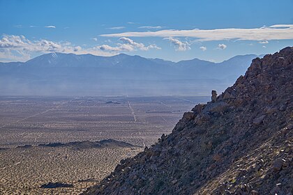
Saddleback Butte State Park is a state park in the Antelope Valley of the western Mojave Desert, in Southern California. It is located east of Lancaster, north of the community of Lake Los Angeles, and south of Edwards in the unincorporated community of Hi Vista.
The prominent feature and namesake of the park is Saddleback Butte, a butte that is 3,651 feet (1,113 m) high.
Saddleback Butte State Park includes over 2,955 acres (4.617 sq mi) of land, and was created in 1960 to protect the area's Joshua Tree (Yucca brevifolia) desert habitat.
See also
- Natural history of the Mojave Desert
- List of California state parks
- Protected areas of the Mojave Desert
Further reading
- Dibblee, Thomas W. Jr. (1967). Geological Survey Professional Paper, Volume 522. U.S. Government Printing Office.
External links

|
| This Los Angeles County, California–related article is a stub. You can help Wikipedia by expanding it. |
- State parks of California
- Antelope Valley
- Buttes of California
- Geography of Palmdale, California
- Landforms of Los Angeles County, California
- Parks in Los Angeles County, California
- Protected areas of the Mojave Desert
- Protected areas established in 1960
- Los Angeles County, California geography stubs
| Saddleback Butte State Park | |
|---|---|
 One of the Saddleback buttes, the Piute Butte, with the
Antelope Valley Indian Museum situated at center | |
| Location | Hi Vista, California, United States |
| Nearest city | Lake Los Angeles, California |
| Coordinates | 34°40′N 117°48′W / 34.667°N 117.800°W / 34.667; -117.800 |
| Area | 2,955 acres (11.96 km2) |
| Established | 1960 |
| Governing body | California Department of Parks and Recreation |
Saddleback Butte State Park is a state park in the Antelope Valley of the western Mojave Desert, in Southern California. It is located east of Lancaster, north of the community of Lake Los Angeles, and south of Edwards in the unincorporated community of Hi Vista.
The prominent feature and namesake of the park is Saddleback Butte, a butte that is 3,651 feet (1,113 m) high.
Saddleback Butte State Park includes over 2,955 acres (4.617 sq mi) of land, and was created in 1960 to protect the area's Joshua Tree (Yucca brevifolia) desert habitat.
See also
- Natural history of the Mojave Desert
- List of California state parks
- Protected areas of the Mojave Desert
Further reading
- Dibblee, Thomas W. Jr. (1967). Geological Survey Professional Paper, Volume 522. U.S. Government Printing Office.
External links

| |||||||||||||||||||||
| |||||||||||||||||||||
| |||||||||||||||||||||
| |||||||||||||||||||||
| |||||||||||||||||||||
| |||||||||||||||||||||
| |||||||||||||||||||||
| |||||||||||||||||||||
| |||||||||||||||||||||
|
| This Los Angeles County, California–related article is a stub. You can help Wikipedia by expanding it. |
- State parks of California
- Antelope Valley
- Buttes of California
- Geography of Palmdale, California
- Landforms of Los Angeles County, California
- Parks in Los Angeles County, California
- Protected areas of the Mojave Desert
- Protected areas established in 1960
- Los Angeles County, California geography stubs

