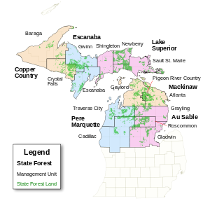
The following is a list of state forests in the U.S. state of Michigan. The Michigan Department of Natural Resources manages the largest state forest system in the nation (2.8 million acres (16,000 km2)), administered by the Forest Resources Division.
In literature describing recreational uses of state forest lands, six state forests are identified. However, state forest lands are administered by fifteen DNR Forest Management Units (FMU). There is no state forest land in the southern portion of the Lower Peninsula.
Upper Peninsula
Northern Lower Peninsula
-
Mackinaw State Forest
- Atlanta FMU ( Alpena, northeast Cheboygan, most of Montmorency, and most of Presque Isle counties) [8]
- Gaylord FMU ( Antrim, Charlevoix, most of Cheboygan, Emmet, and most of Otsego counties) [9]
- Pigeon River Country FMU (southeast Cheboygan, northwest Montmorency, northeast Otsego, and southwest Presque Isle counties) [10]
- Pere Marquette State Forest
- Au Sable State Forest
References
- Map of DNR Forest Management Units
- Upper Peninsula State Forest Campgrounds and Pathways (PDF)[ dead link]
- Northern Lower Peninsula State Forest Campgrounds and Pathways (PDF)[ dead link]
See also

The following is a list of state forests in the U.S. state of Michigan. The Michigan Department of Natural Resources manages the largest state forest system in the nation (2.8 million acres (16,000 km2)), administered by the Forest Resources Division.
In literature describing recreational uses of state forest lands, six state forests are identified. However, state forest lands are administered by fifteen DNR Forest Management Units (FMU). There is no state forest land in the southern portion of the Lower Peninsula.
Upper Peninsula
Northern Lower Peninsula
-
Mackinaw State Forest
- Atlanta FMU ( Alpena, northeast Cheboygan, most of Montmorency, and most of Presque Isle counties) [8]
- Gaylord FMU ( Antrim, Charlevoix, most of Cheboygan, Emmet, and most of Otsego counties) [9]
- Pigeon River Country FMU (southeast Cheboygan, northwest Montmorency, northeast Otsego, and southwest Presque Isle counties) [10]
- Pere Marquette State Forest
- Au Sable State Forest
References
- Map of DNR Forest Management Units
- Upper Peninsula State Forest Campgrounds and Pathways (PDF)[ dead link]
- Northern Lower Peninsula State Forest Campgrounds and Pathways (PDF)[ dead link]