Photos • Location


Size of this preview:
800 × 192 pixels. Other resolutions:
320 × 77 pixels |
640 × 153 pixels |
1,024 × 245 pixels |
1,280 × 307 pixels |
4,757 × 1,140 pixels.
Original file (4,757 × 1,140 pixels, file size: 3.46 MB, MIME type: image/jpeg)
| This is a file from the
Wikimedia Commons. Information from its
description page there is shown below. Commons is a freely licensed media file repository. You can help. |
Summary
| Description |
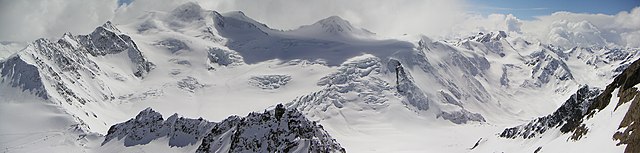
English: Austrian Mountain
Wildspitze (3768 m, second highest mountain in Austria) seen from the Hinterer Brunnkogel (3440 m), the highest point of the ski area of the Pitztal glacier ski resort in Tyrolia. Right beside is the mountain named Hinterer Brochkogel. In the lower left corner, when enlarged, a ski lift and some people on skis can be recognized at the saddle called Mittelbergjoch, an important passageway for mountaineers on the way up to the Wildspitze.
The original pictures were taken on 17 April 2005 with a Minolta X20 digital camera, the stitching process of the four pictures used was carried out at an unknown date between this date and the upload date to Commons in 2009. Deutsch: Die
Wildspitze (3768 m, zweithöchster Berg Österreichs) vom Hinteren Brunnkogel (3440 m) aus gesehen, dem höchsten Punkt des Gletscherskigebiets Pitztal in Tirol. Es folgt nach rechts der
Hintere Brochkogel. In der linken unteren Ecke kann man in vergrößerter Ansicht einen Skilift und mehrere Skifahrer am Sattel "Mittelbergjoch" erkennen, einer wichtigen Passage für Bergsteiger beim Aufstieg zur Wildspitze. Die für den Stitching-Prozess verwendeten Einzelbilder wurden am 17. April 2005 mit einer Digitalkamera Minolta X20 aufgenommen. Der Zusammenbau des Panoramabilds fand zu einem unbekannten Zeitpunkt zwischen diesem Datum und dem Upload auf Commons 2009 statt. |
||
| Date | |||
| Source | Own work | ||
| Author | Pittigrilli | ||
| Permission ( Reusing this file) |
|
||
| Other versions |
Derivative works of this file:
|
_with_saddle_Mittelbergjoch_and_ski_lift_in_front.jpg)


_in_Tyrolia,_Austria,_August_2018_(above)_and_April_2005_(below).jpg)
| Camera location |
| View this and other nearby images on: OpenStreetMap |
|
|---|
Licensing
I, the copyright holder of this work, hereby publish it under the following licenses:

|
Permission is granted to copy, distribute and/or modify this document under the terms of the GNU Free Documentation License, Version 1.2 or any later version published by the Free Software Foundation; with no Invariant Sections, no Front-Cover Texts, and no Back-Cover Texts. A copy of the license is included in the section entitled GNU Free Documentation License. |
This file is licensed under the
Creative Commons Attribution-Share Alike
3.0 Unported,
2.5 Generic,
2.0 Generic and
1.0 Generic license.
- You are free:
- to share – to copy, distribute and transmit the work
- to remix – to adapt the work
- Under the following conditions:
- attribution – You must give appropriate credit, provide a link to the license, and indicate if changes were made. You may do so in any reasonable manner, but not in any way that suggests the licensor endorses you or your use.
- share alike – If you remix, transform, or build upon the material, you must distribute your contributions under the same or compatible license as the original.
You may select the license of your choice.
Categories
File history
Click on a date/time to view the file as it appeared at that time.
| Date/Time | Thumbnail | Dimensions | User | Comment | |
|---|---|---|---|---|---|
| current | 16:10, 11 November 2009 |
| 4,757 × 1,140 (3.46 MB) | Pittigrilli | Version with bigger viewing angle |
| 15:57, 11 November 2009 |
| 3,500 × 1,138 (2.49 MB) | Pittigrilli | {{Information |Description={{en|1=Austrian Mountain Wildspitze (3768 m, second highest mountain in Austria) seen from the Hinterer Brunnkogel (3440 m), the highest point of the ski area of the Pitztal glacier in tyrolia}} {{de|1=Die Wildspitze (3768 m, zw |
File usage
The following pages on the English Wikipedia use this file (pages on other projects are not listed):
Global file usage
The following other wikis use this file:
- Usage on als.wikipedia.org
- Usage on de.wikipedia.org
- Usage on el.wikipedia.org
- Usage on sr.wikipedia.org
Metadata
Size of this preview:
800 × 192 pixels. Other resolutions:
320 × 77 pixels |
640 × 153 pixels |
1,024 × 245 pixels |
1,280 × 307 pixels |
4,757 × 1,140 pixels.
Original file (4,757 × 1,140 pixels, file size: 3.46 MB, MIME type: image/jpeg)
| This is a file from the
Wikimedia Commons. Information from its
description page there is shown below. Commons is a freely licensed media file repository. You can help. |
Summary
| Description |
English: Austrian Mountain
Wildspitze (3768 m, second highest mountain in Austria) seen from the Hinterer Brunnkogel (3440 m), the highest point of the ski area of the Pitztal glacier ski resort in Tyrolia. Right beside is the mountain named Hinterer Brochkogel. In the lower left corner, when enlarged, a ski lift and some people on skis can be recognized at the saddle called Mittelbergjoch, an important passageway for mountaineers on the way up to the Wildspitze.
The original pictures were taken on 17 April 2005 with a Minolta X20 digital camera, the stitching process of the four pictures used was carried out at an unknown date between this date and the upload date to Commons in 2009. Deutsch: Die
Wildspitze (3768 m, zweithöchster Berg Österreichs) vom Hinteren Brunnkogel (3440 m) aus gesehen, dem höchsten Punkt des Gletscherskigebiets Pitztal in Tirol. Es folgt nach rechts der
Hintere Brochkogel. In der linken unteren Ecke kann man in vergrößerter Ansicht einen Skilift und mehrere Skifahrer am Sattel "Mittelbergjoch" erkennen, einer wichtigen Passage für Bergsteiger beim Aufstieg zur Wildspitze. Die für den Stitching-Prozess verwendeten Einzelbilder wurden am 17. April 2005 mit einer Digitalkamera Minolta X20 aufgenommen. Der Zusammenbau des Panoramabilds fand zu einem unbekannten Zeitpunkt zwischen diesem Datum und dem Upload auf Commons 2009 statt. |
||
| Date | |||
| Source | Own work | ||
| Author | Pittigrilli | ||
| Permission ( Reusing this file) |
|
||
| Other versions |
Derivative works of this file:
|
| Camera location |
| View this and other nearby images on: OpenStreetMap |
|
|---|
Licensing
I, the copyright holder of this work, hereby publish it under the following licenses:
|
|
Permission is granted to copy, distribute and/or modify this document under the terms of the GNU Free Documentation License, Version 1.2 or any later version published by the Free Software Foundation; with no Invariant Sections, no Front-Cover Texts, and no Back-Cover Texts. A copy of the license is included in the section entitled GNU Free Documentation License. |
This file is licensed under the
Creative Commons Attribution-Share Alike
3.0 Unported,
2.5 Generic,
2.0 Generic and
1.0 Generic license.
- You are free:
- to share – to copy, distribute and transmit the work
- to remix – to adapt the work
- Under the following conditions:
- attribution – You must give appropriate credit, provide a link to the license, and indicate if changes were made. You may do so in any reasonable manner, but not in any way that suggests the licensor endorses you or your use.
- share alike – If you remix, transform, or build upon the material, you must distribute your contributions under the same or compatible license as the original.
You may select the license of your choice.
Categories
File history
Click on a date/time to view the file as it appeared at that time.
| Date/Time | Thumbnail | Dimensions | User | Comment | |
|---|---|---|---|---|---|
| current | 16:10, 11 November 2009 |
| 4,757 × 1,140 (3.46 MB) | Pittigrilli | Version with bigger viewing angle |
| 15:57, 11 November 2009 |
| 3,500 × 1,138 (2.49 MB) | Pittigrilli | {{Information |Description={{en|1=Austrian Mountain Wildspitze (3768 m, second highest mountain in Austria) seen from the Hinterer Brunnkogel (3440 m), the highest point of the ski area of the Pitztal glacier in tyrolia}} {{de|1=Die Wildspitze (3768 m, zw |
File usage
The following pages on the English Wikipedia use this file (pages on other projects are not listed):
Global file usage
The following other wikis use this file:
- Usage on als.wikipedia.org
- Usage on de.wikipedia.org
- Usage on el.wikipedia.org
- Usage on sr.wikipedia.org