Photos • Location


Size of this preview:
800 × 533 pixels. Other resolutions:
320 × 213 pixels |
640 × 426 pixels |
1,024 × 682 pixels |
1,280 × 853 pixels |
2,362 × 1,574 pixels.
Original file (2,362 × 1,574 pixels, file size: 3.42 MB, MIME type: image/jpeg)
| This is a file from the
Wikimedia Commons. Information from its
description page there is shown below. Commons is a freely licensed media file repository. You can help. |
Summary
| Description |
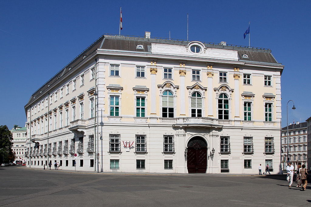
Deutsch: Das Bundeskanzleramt an der Adresse Ballhausplatz 2 im 1. Wiener Gemeindebezirk Innere Stadt.
Ursprünglich wurde es im Auftrag Karls VI. vom Hofarchitekten Johann Lukas von Hildebrandt (Baumeister Christian Alexander Oedtl) als repräsentatives Gebäude für die damalige Geheime Hofkanzlei erbaut (Grundsteinlegung am 13. September 1717) und diente später als Staatskanzlei. Von 1764 bis 1767 wurde das Gebäude im Auftrag Maria Theresias von ihrem Hofarchitekten Nikolaus Pacassi verändert und bedeutend erweitert, wobei die Hauptfassade zum Ballhausplatz hin an sich nur gering verändert wurde. 1922 übersiedelte das Bundeskanzleramt aus seinem ursprünglichen Amtssitz im Palais Modena (heute Innenministerium) hierher. In dem Gebäude amtierten in der Zeit der I. Republik auch noch der Bundespräsident (Trakt in der Löwelstraße) und der Außenminister: [1]. English: Building of the Federal Chancellery on Ballhausplatz in Vienna.
|
| Date | |
| Source | Own work |
| Author | C.Stadler/Bwag |
| Permission ( Reusing this file) |
Deutsch: Hallo, du darfst mein Foto kostenlos nutzen, aber nenne mich bitte als Fotograf, beispielsweise „Foto: C.Stadler/Bwag“ oder © C.Stadler/Bwag; CC-BY-SA-4.0. Auf mehr Angaben bestehe ich nicht - im Gegensatz zu manch anderen, die die Vorgaben der unten angeführten Lizenzierung auf Punkt und Beistrich einfordern. English: Feel free to use my photos, but please mention me as the author like © C.Stadler/Bwag or © C.Stadler/Bwag; CC-BY-SA-4.0 (that's good enough) and if you want send me a message: bwag@gmx.net. |
| Other versions |
|
.JPG)
| Object location |
| View this and other nearby images on: OpenStreetMap |
|
|---|
| Camera location |
| View this and other nearby images on: OpenStreetMap |
|
|---|
Licensing
I, the copyright holder of this work, hereby publish it under the following license:
This file is licensed under the
Creative Commons
Attribution-Share Alike 3.0 Unported license.
- You are free:
- to share – to copy, distribute and transmit the work
- to remix – to adapt the work
- Under the following conditions:
- attribution – You must give appropriate credit, provide a link to the license, and indicate if changes were made. You may do so in any reasonable manner, but not in any way that suggests the licensor endorses you or your use.
- share alike – If you remix, transform, or build upon the material, you must distribute your contributions under the same or compatible license as the original.

|
This image was uploaded as part of
Wiki Loves Monuments 2011.
|
File history
Click on a date/time to view the file as it appeared at that time.
| Date/Time | Thumbnail | Dimensions | User | Comment | |
|---|---|---|---|---|---|
| current | 20:15, 27 September 2011 |
| 2,362 × 1,574 (3.42 MB) | Bwag | {{Information |Description= {{de|1= Das österreichische Bundeskanzleramt, Ballhausplatz 2, 1010 Wien.}} {{Denkmalgeschütztes Objekt Österreich|1=50446}} |Source= {{own}} |Date= 2011-09-25 |Author= [[User:Bwag|Bwa |
File usage
The following pages on the English Wikipedia use this file (pages on other projects are not listed):
Global file usage
The following other wikis use this file:
- Usage on af.wikipedia.org
- Usage on ar.wikipedia.org
- Usage on be-tarask.wikipedia.org
- Usage on ca.wikipedia.org
- Usage on de.wikipedia.org
- Usage on el.wikipedia.org
- Usage on eo.wikipedia.org
- Usage on es.wikipedia.org
- Usage on fr.wikipedia.org
- Chancellerie fédérale (Autriche)
- Wikipédia:Lumière sur/Mai 2018
- Conférence de Vienne (16 mars 1917)
- Wikipédia:Lumière sur/Conférence de Vienne (16 mars 1917)
- Wikipédia:Lumière sur/Juillet 2018
- Conférence de Vienne (22 octobre 1917)
- Conférence de Vienne (1er septembre 1917)
- Conférence de Vienne (1er août 1917)
- Wikipédia:Lumière sur/Conférence de Vienne (22 octobre 1917)
- Wikipédia:Lumière sur/Novembre 2018
- Wikipédia:Lumière sur/Conférence de Vienne (1er août 1917)
- Usage on id.wikipedia.org
- Usage on it.wikipedia.org
- Usage on ja.wikipedia.org
- Usage on mk.wikipedia.org
- Usage on no.wikipedia.org
- Usage on pl.wikipedia.org
- Usage on ru.wikipedia.org
- Usage on sd.wikipedia.org
- Usage on sl.wikipedia.org
- Usage on sr.wikipedia.org
- Usage on tum.wikipedia.org
- Usage on uk.wikipedia.org
Metadata
Size of this preview:
800 × 533 pixels. Other resolutions:
320 × 213 pixels |
640 × 426 pixels |
1,024 × 682 pixels |
1,280 × 853 pixels |
2,362 × 1,574 pixels.
Original file (2,362 × 1,574 pixels, file size: 3.42 MB, MIME type: image/jpeg)
| This is a file from the
Wikimedia Commons. Information from its
description page there is shown below. Commons is a freely licensed media file repository. You can help. |
Summary
| Description |
Deutsch: Das Bundeskanzleramt an der Adresse Ballhausplatz 2 im 1. Wiener Gemeindebezirk Innere Stadt.
Ursprünglich wurde es im Auftrag Karls VI. vom Hofarchitekten Johann Lukas von Hildebrandt (Baumeister Christian Alexander Oedtl) als repräsentatives Gebäude für die damalige Geheime Hofkanzlei erbaut (Grundsteinlegung am 13. September 1717) und diente später als Staatskanzlei. Von 1764 bis 1767 wurde das Gebäude im Auftrag Maria Theresias von ihrem Hofarchitekten Nikolaus Pacassi verändert und bedeutend erweitert, wobei die Hauptfassade zum Ballhausplatz hin an sich nur gering verändert wurde. 1922 übersiedelte das Bundeskanzleramt aus seinem ursprünglichen Amtssitz im Palais Modena (heute Innenministerium) hierher. In dem Gebäude amtierten in der Zeit der I. Republik auch noch der Bundespräsident (Trakt in der Löwelstraße) und der Außenminister: [1]. English: Building of the Federal Chancellery on Ballhausplatz in Vienna.
|
| Date | |
| Source | Own work |
| Author | C.Stadler/Bwag |
| Permission ( Reusing this file) |
Deutsch: Hallo, du darfst mein Foto kostenlos nutzen, aber nenne mich bitte als Fotograf, beispielsweise „Foto: C.Stadler/Bwag“ oder © C.Stadler/Bwag; CC-BY-SA-4.0. Auf mehr Angaben bestehe ich nicht - im Gegensatz zu manch anderen, die die Vorgaben der unten angeführten Lizenzierung auf Punkt und Beistrich einfordern. English: Feel free to use my photos, but please mention me as the author like © C.Stadler/Bwag or © C.Stadler/Bwag; CC-BY-SA-4.0 (that's good enough) and if you want send me a message: bwag@gmx.net. |
| Other versions |
|
| Object location |
| View this and other nearby images on: OpenStreetMap |
|
|---|
| Camera location |
| View this and other nearby images on: OpenStreetMap |
|
|---|
Licensing
I, the copyright holder of this work, hereby publish it under the following license:
This file is licensed under the
Creative Commons
Attribution-Share Alike 3.0 Unported license.
- You are free:
- to share – to copy, distribute and transmit the work
- to remix – to adapt the work
- Under the following conditions:
- attribution – You must give appropriate credit, provide a link to the license, and indicate if changes were made. You may do so in any reasonable manner, but not in any way that suggests the licensor endorses you or your use.
- share alike – If you remix, transform, or build upon the material, you must distribute your contributions under the same or compatible license as the original.
|
|
This image was uploaded as part of
Wiki Loves Monuments 2011.
|
File history
Click on a date/time to view the file as it appeared at that time.
| Date/Time | Thumbnail | Dimensions | User | Comment | |
|---|---|---|---|---|---|
| current | 20:15, 27 September 2011 |
| 2,362 × 1,574 (3.42 MB) | Bwag | {{Information |Description= {{de|1= Das österreichische Bundeskanzleramt, Ballhausplatz 2, 1010 Wien.}} {{Denkmalgeschütztes Objekt Österreich|1=50446}} |Source= {{own}} |Date= 2011-09-25 |Author= [[User:Bwag|Bwa |
File usage
The following pages on the English Wikipedia use this file (pages on other projects are not listed):
Global file usage
The following other wikis use this file:
- Usage on af.wikipedia.org
- Usage on ar.wikipedia.org
- Usage on be-tarask.wikipedia.org
- Usage on ca.wikipedia.org
- Usage on de.wikipedia.org
- Usage on el.wikipedia.org
- Usage on eo.wikipedia.org
- Usage on es.wikipedia.org
- Usage on fr.wikipedia.org
- Chancellerie fédérale (Autriche)
- Wikipédia:Lumière sur/Mai 2018
- Conférence de Vienne (16 mars 1917)
- Wikipédia:Lumière sur/Conférence de Vienne (16 mars 1917)
- Wikipédia:Lumière sur/Juillet 2018
- Conférence de Vienne (22 octobre 1917)
- Conférence de Vienne (1er septembre 1917)
- Conférence de Vienne (1er août 1917)
- Wikipédia:Lumière sur/Conférence de Vienne (22 octobre 1917)
- Wikipédia:Lumière sur/Novembre 2018
- Wikipédia:Lumière sur/Conférence de Vienne (1er août 1917)
- Usage on id.wikipedia.org
- Usage on it.wikipedia.org
- Usage on ja.wikipedia.org
- Usage on mk.wikipedia.org
- Usage on no.wikipedia.org
- Usage on pl.wikipedia.org
- Usage on ru.wikipedia.org
- Usage on sd.wikipedia.org
- Usage on sl.wikipedia.org
- Usage on sr.wikipedia.org
- Usage on tum.wikipedia.org
- Usage on uk.wikipedia.org