Photos • Location


Size of this preview:
800 × 380 pixels. Other resolutions:
320 × 152 pixels |
640 × 304 pixels |
1,024 × 486 pixels |
1,280 × 608 pixels |
3,101 × 1,473 pixels.
Original file (3,101 × 1,473 pixels, file size: 4.85 MB, MIME type: image/jpeg)
| This is a file from the
Wikimedia Commons. Information from its
description page there is shown below. Commons is a freely licensed media file repository. You can help. |
Summary
| Description |
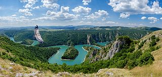
English: Uvac River from the boat perspective. The Uvac is an international trans-boundary river, rising under Golija mountain and Pešter plateau, then flowing through southwestern Serbia and cross into eastern Bosnia and Herzegovina where, after 119 km, finally meets the Lim river from the right, however, before it empties into the Lim, for a 10 kilometers Uvac forms the border between two countries. Also, while meandering through Serbia, Uvac loosely makes the northern border of the Raška region too.
|
||
| Date | |||
| Source | Own work | ||
| Author | Sasapokimica |
| Camera location |
| View this and other nearby images on: OpenStreetMap |
|
|---|
Licensing
I, the copyright holder of this work, hereby publish it under the following license:
This file is licensed under the
Creative Commons
Attribution-Share Alike 4.0 International license.
- You are free:
- to share – to copy, distribute and transmit the work
- to remix – to adapt the work
- Under the following conditions:
- attribution – You must give appropriate credit, provide a link to the license, and indicate if changes were made. You may do so in any reasonable manner, but not in any way that suggests the licensor endorses you or your use.
- share alike – If you remix, transform, or build upon the material, you must distribute your contributions under the same or compatible license as the original.
|
|
This image was uploaded as part of
Wiki Loves Earth 2016.
|
 |
File history
Click on a date/time to view the file as it appeared at that time.
| Date/Time | Thumbnail | Dimensions | User | Comment | |
|---|---|---|---|---|---|
| current | 08:58, 23 May 2016 |
| 3,101 × 1,473 (4.85 MB) | Sasapokimica | User created page with UploadWizard |
File usage
The following pages on the English Wikipedia use this file (pages on other projects are not listed):
Global file usage
The following other wikis use this file:
- Usage on arz.wikipedia.org
- Usage on bg.wikipedia.org
- Usage on bn.wikipedia.org
- Usage on bs.wikipedia.org
- Usage on cs.wikipedia.org
- Usage on de.wikipedia.org
- Usage on el.wikipedia.org
- Usage on hr.wikipedia.org
- Usage on it.wikipedia.org
- Usage on mk.wikipedia.org
- Usage on ne.wikipedia.org
- Usage on no.wikipedia.org
- Usage on ro.wikipedia.org
- Usage on ru.wikipedia.org
- Usage on sl.wikipedia.org
- Usage on sr.wikipedia.org
- Србија
- Увац
- Резервати природе Србије
- Специјални резерват природе Увац
- Списак заштићених подручја у Шумадији и западној Србији
- Википедија:Предлози за изабране слике/Архива 2
- Википедија:Вики воли Земљу 2023./Списак заштићених подручја
- Википедија:Вики воли Земљу 2023./Резервати природе
- Википедија:Вики воли Земљу 2023./Заштићена подручја у Шумадији и западној Србији
- Википедија:Уређивачки маратон Вики воли Земљу 2023./Потребни чланци
- Википедија:Вики воли Земљу 2024./Списак заштићених подручја
- Википедија:Вики воли Земљу 2024./Резервати природе
- Usage on te.wikipedia.org
- Usage on uk.wikipedia.org
- Usage on uz.wikipedia.org
- Usage on www.wikidata.org
- Usage on zh.wikipedia.org
Metadata
Size of this preview:
800 × 380 pixels. Other resolutions:
320 × 152 pixels |
640 × 304 pixels |
1,024 × 486 pixels |
1,280 × 608 pixels |
3,101 × 1,473 pixels.
Original file (3,101 × 1,473 pixels, file size: 4.85 MB, MIME type: image/jpeg)
| This is a file from the
Wikimedia Commons. Information from its
description page there is shown below. Commons is a freely licensed media file repository. You can help. |
Summary
| Description |
English: Uvac River from the boat perspective. The Uvac is an international trans-boundary river, rising under Golija mountain and Pešter plateau, then flowing through southwestern Serbia and cross into eastern Bosnia and Herzegovina where, after 119 km, finally meets the Lim river from the right, however, before it empties into the Lim, for a 10 kilometers Uvac forms the border between two countries. Also, while meandering through Serbia, Uvac loosely makes the northern border of the Raška region too.
|
||
| Date | |||
| Source | Own work | ||
| Author | Sasapokimica |
| Camera location |
| View this and other nearby images on: OpenStreetMap |
|
|---|
Licensing
I, the copyright holder of this work, hereby publish it under the following license:
This file is licensed under the
Creative Commons
Attribution-Share Alike 4.0 International license.
- You are free:
- to share – to copy, distribute and transmit the work
- to remix – to adapt the work
- Under the following conditions:
- attribution – You must give appropriate credit, provide a link to the license, and indicate if changes were made. You may do so in any reasonable manner, but not in any way that suggests the licensor endorses you or your use.
- share alike – If you remix, transform, or build upon the material, you must distribute your contributions under the same or compatible license as the original.
|
|
This image was uploaded as part of
Wiki Loves Earth 2016.
|
|
File history
Click on a date/time to view the file as it appeared at that time.
| Date/Time | Thumbnail | Dimensions | User | Comment | |
|---|---|---|---|---|---|
| current | 08:58, 23 May 2016 |
| 3,101 × 1,473 (4.85 MB) | Sasapokimica | User created page with UploadWizard |
File usage
The following pages on the English Wikipedia use this file (pages on other projects are not listed):
Global file usage
The following other wikis use this file:
- Usage on arz.wikipedia.org
- Usage on bg.wikipedia.org
- Usage on bn.wikipedia.org
- Usage on bs.wikipedia.org
- Usage on cs.wikipedia.org
- Usage on de.wikipedia.org
- Usage on el.wikipedia.org
- Usage on hr.wikipedia.org
- Usage on it.wikipedia.org
- Usage on mk.wikipedia.org
- Usage on ne.wikipedia.org
- Usage on no.wikipedia.org
- Usage on ro.wikipedia.org
- Usage on ru.wikipedia.org
- Usage on sl.wikipedia.org
- Usage on sr.wikipedia.org
- Србија
- Увац
- Резервати природе Србије
- Специјални резерват природе Увац
- Списак заштићених подручја у Шумадији и западној Србији
- Википедија:Предлози за изабране слике/Архива 2
- Википедија:Вики воли Земљу 2023./Списак заштићених подручја
- Википедија:Вики воли Земљу 2023./Резервати природе
- Википедија:Вики воли Земљу 2023./Заштићена подручја у Шумадији и западној Србији
- Википедија:Уређивачки маратон Вики воли Земљу 2023./Потребни чланци
- Википедија:Вики воли Земљу 2024./Списак заштићених подручја
- Википедија:Вики воли Земљу 2024./Резервати природе
- Usage on te.wikipedia.org
- Usage on uk.wikipedia.org
- Usage on uz.wikipedia.org
- Usage on www.wikidata.org
- Usage on zh.wikipedia.org