Size of this preview:
363 × 600 pixels. Other resolutions:
145 × 240 pixels |
465 × 768 pixels.
Original file (465 × 768 pixels, file size: 130 KB, MIME type: image/png)
| This is a file from the
Wikimedia Commons. Information from its
description page there is shown below. Commons is a freely licensed media file repository. You can help. |
Summary
| Description |
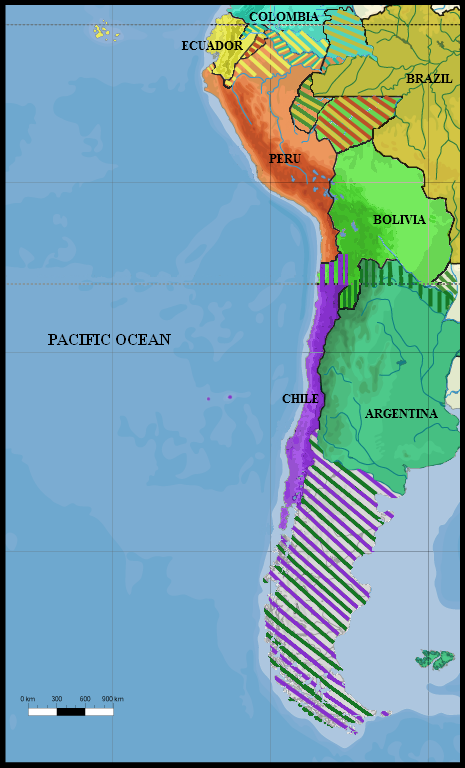
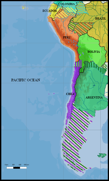
English: South America in 1879, prior to the start of the War of the Pacific. Based on the following maps:
|
| Date | |
| Source | Own work |
| Author | MarshalN20 |
| Other versions | File:SouthAmerica1865 ChinchaIslandsWar.png |
.jpg)
Licensing
I, the copyright holder of this work, hereby publish it under the following license:
This file is licensed under the
Creative Commons
Attribution 3.0 Unported license.
- You are free:
- to share – to copy, distribute and transmit the work
- to remix – to adapt the work
- Under the following conditions:
- attribution – You must give appropriate credit, provide a link to the license, and indicate if changes were made. You may do so in any reasonable manner, but not in any way that suggests the licensor endorses you or your use.
File history
Click on a date/time to view the file as it appeared at that time.
| Date/Time | Thumbnail | Dimensions | User | Comment | |
|---|---|---|---|---|---|
| current | 18:55, 24 February 2018 |
| 465 × 768 (130 KB) | Janitoalevic | Juan Fernández Islands |
| 18:50, 24 February 2018 |
 | 465 × 768 (130 KB) | Janitoalevic | . | |
| 18:31, 24 February 2018 |
 | 465 × 768 (130 KB) | Janitoalevic | Better Patagonia | |
| 22:48, 28 January 2015 |
 | 465 × 768 (168 KB) | Keysanger | added Atacama dispute, and Tarija Dispute | |
| 17:56, 8 August 2011 |
 | 465 × 768 (136 KB) | MarshalN20 | {{Information |Description ={{en|1=South America in 1879, prior to the start of the War of the Pacific. Based on the following maps: * File:Wotp.en.svg: Atacama border dispute map. * File:B-C-E-P claims and reivindications.jpg: Amazon border di |
File usage
The following pages on the English Wikipedia use this file (pages on other projects are not listed):
Global file usage
The following other wikis use this file:
- Usage on ar.wikipedia.org
- Usage on az.wikipedia.org
- Usage on bn.wikipedia.org
- Usage on es.wikipedia.org
- Usage on ja.wikipedia.org
- Usage on mk.wikipedia.org
- Usage on pt.wikipedia.org
- Usage on te.wikipedia.org
Metadata
Size of this preview:
363 × 600 pixels. Other resolutions:
145 × 240 pixels |
465 × 768 pixels.
Original file (465 × 768 pixels, file size: 130 KB, MIME type: image/png)
| This is a file from the
Wikimedia Commons. Information from its
description page there is shown below. Commons is a freely licensed media file repository. You can help. |
Summary
| Description |
English: South America in 1879, prior to the start of the War of the Pacific. Based on the following maps:
|
| Date | |
| Source | Own work |
| Author | MarshalN20 |
| Other versions | File:SouthAmerica1865 ChinchaIslandsWar.png |
Licensing
I, the copyright holder of this work, hereby publish it under the following license:
This file is licensed under the
Creative Commons
Attribution 3.0 Unported license.
- You are free:
- to share – to copy, distribute and transmit the work
- to remix – to adapt the work
- Under the following conditions:
- attribution – You must give appropriate credit, provide a link to the license, and indicate if changes were made. You may do so in any reasonable manner, but not in any way that suggests the licensor endorses you or your use.
File history
Click on a date/time to view the file as it appeared at that time.
| Date/Time | Thumbnail | Dimensions | User | Comment | |
|---|---|---|---|---|---|
| current | 18:55, 24 February 2018 |
| 465 × 768 (130 KB) | Janitoalevic | Juan Fernández Islands |
| 18:50, 24 February 2018 |
| 465 × 768 (130 KB) | Janitoalevic | . | |
| 18:31, 24 February 2018 |
| 465 × 768 (130 KB) | Janitoalevic | Better Patagonia | |
| 22:48, 28 January 2015 |
| 465 × 768 (168 KB) | Keysanger | added Atacama dispute, and Tarija Dispute | |
| 17:56, 8 August 2011 |
| 465 × 768 (136 KB) | MarshalN20 | {{Information |Description ={{en|1=South America in 1879, prior to the start of the War of the Pacific. Based on the following maps: * File:Wotp.en.svg: Atacama border dispute map. * File:B-C-E-P claims and reivindications.jpg: Amazon border di |
File usage
The following pages on the English Wikipedia use this file (pages on other projects are not listed):
Global file usage
The following other wikis use this file:
- Usage on ar.wikipedia.org
- Usage on az.wikipedia.org
- Usage on bn.wikipedia.org
- Usage on es.wikipedia.org
- Usage on ja.wikipedia.org
- Usage on mk.wikipedia.org
- Usage on pt.wikipedia.org
- Usage on te.wikipedia.org