
Size of this preview:
525 × 600 pixels. Other resolutions:
210 × 240 pixels |
420 × 480 pixels |
672 × 768 pixels |
896 × 1,024 pixels |
2,067 × 2,362 pixels.
Original file (2,067 × 2,362 pixels, file size: 1.09 MB, MIME type: image/png)
| This is a file from the
Wikimedia Commons. Information from its
description page there is shown below. Commons is a freely licensed media file repository. You can help. |
Summary
| Description |
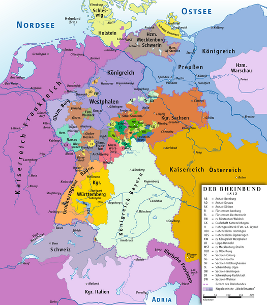
Deutsch: Karte des Rheinbundes 1812
English: Map of Confederation of the Rhine 1812 |
||||||||
| Date | |||||||||
| Source | Own work drawing/Source of Information: Putzger – Historischer Weltatlas, 89. Auflage, 1965; Westermanns Großer Atlas zuur Weltgeschichte, 1969; Haacks geographischer Atlas. VEB Hermann Haack Geographisch-Kartographische Anstalt, Gotha/Leipzig, 1. Auflage, 1979. | ||||||||
| Author | ziegelbrenner | ||||||||
| Permission ( Reusing this file) |
I, the copyright holder of this work, hereby publish it under the following licenses:
This file is licensed under the
Creative Commons
Attribution 2.5 Generic license.
You may select the license of your choice. |


|
This historical map image could be re-created using
vector graphics as an
SVG file. This has several advantages; see
Commons:Media for cleanup for more information. If an SVG form of this image is available, please upload it and afterwards replace this template with
{{
vector version available|new image name}}
.
It is recommended to name the SVG file “Rheinbund 1812, political map.svg”—then the template Vector version available (or Vva) does not need the new image name parameter. |
File history
Click on a date/time to view the file as it appeared at that time.
| Date/Time | Thumbnail | Dimensions | User | Comment | |
|---|---|---|---|---|---|
| current | 11:49, 14 February 2014 |
| 2,067 × 2,362 (1.09 MB) | Ziegelbrenner | 2014-02-14 |
| 10:33, 3 February 2014 |
 | 2,068 × 2,362 (1.89 MB) | Ziegelbrenner | 2014-02-03 | |
| 13:28, 31 January 2014 |
 | 525 × 600 (182 KB) | Ziegelbrenner | Reverted to version as of 14:58, 21 January 2014 Why did you revert this? New version has some corrections. | |
| 16:14, 30 January 2014 |
 | 2,008 × 2,362 (1.72 MB) | Эрманарих | Reverted to version as of 15:13, 3 February 2011 | |
| 14:58, 21 January 2014 |
 | 525 × 600 (182 KB) | Ziegelbrenner | Some borders corrected | |
| 15:13, 3 February 2011 |
 | 2,008 × 2,362 (1.72 MB) | Ziegelbrenner | 2011-02-03 | |
| 15:08, 3 February 2011 |
 | 2,008 × 2,362 (1.72 MB) | Ziegelbrenner | 2011-02-03 | |
| 14:56, 3 February 2011 |
 | 2,067 × 2,362 (1.76 MB) | Ziegelbrenner | 2011-02-03 | |
| 10:43, 3 February 2011 |
 | 2,008 × 2,362 (3.49 MB) | Ziegelbrenner | 2011-02-03 | |
| 18:04, 30 May 2010 |
 | 2,067 × 2,362 (2.44 MB) | Max96 | Edited out the purple "blob" in Thuringia |
File usage
The following pages on the English Wikipedia use this file (pages on other projects are not listed):
- 18th-century history of Germany
- Anhalt-Bernburg
- Anhalt-Dessau
- Anhalt-Köthen
- Arenberg
- Bavaria
- Confederation of the Rhine
- County of Isenburg
- Duchy of Anhalt
- Duchy of Berg
- Duchy of Mecklenburg-Schwerin
- Duchy of Mecklenburg-Strelitz
- Duchy of Nassau
- Duchy of Oldenburg
- Grand Duchy of Baden
- Grand Duchy of Berg
- Grand Duchy of Frankfurt
- Grand Duchy of Hesse
- Grand Duchy of Würzburg
- History of Germany
- History of Liechtenstein
- Hohenzollern-Hechingen
- Hohenzollern-Sigmaringen
- Influence of the French Revolution
- Kingdom of Bavaria
- Kingdom of Saxony
- Kingdom of Westphalia
- Kingdom of Württemberg
- Liechtenstein
- Principality of Aschaffenburg
- Principality of Leyen
- Principality of Lippe
- Principality of Regensburg
- Principality of Reuss-Gera
- Principality of Reuss-Greiz
- Principality of Salm
- Principality of Schaumburg-Lippe
- Principality of Waldeck and Pyrmont
- Reuss-Ebersdorf
- Reuss-Lobenstein
- Salm (state)
- Saxe-Coburg-Saalfeld
- Saxe-Eisenach
- Saxe-Gotha-Altenburg
- Saxe-Hildburghausen
- Saxe-Meiningen
- Saxe-Weimar
- Saxe-Weimar-Eisenach
- Schwarzburg-Rudolstadt
- Schwarzburg-Sondershausen
- User:Falcaorib
- User:Michael!/Deutschland
- User:WinstonMaplewalnut/sandbox
- Template:States of the Confederation of the Rhine
Global file usage
The following other wikis use this file:
- Usage on an.wikipedia.org
- Usage on ar.wikipedia.org
- Usage on ast.wikipedia.org
- Usage on azb.wikipedia.org
- Usage on be.wikipedia.org
- Usage on br.wikipedia.org
- Usage on ca.wikipedia.org
- Liechtenstein
- Waldeck
- Confederació del Rin
- Ducat de Nassau
- Plantilla:Estats de la Confederació del Rin
- Gran Ducat de Berg
- Comtat d'Arenberg
- Hohenzollern-Sigmaringen
- Regne de Saxònia
- Regne de Westfàlia
- Regne de Baviera
- Gran ducat de Hessen i del Rin
- Regne de Württemberg
- Gran Ducat de Baden
- Anhalt
- Anhalt-Bernburg
- Anhalt-Dessau
- Anhalt-Köthen
- Saxònia-Weimar-Eisenach
- Saxònia-Eisenach
- Reuss-Ebersdorf
- Reuss-Lobenstein
- Schaumburg-Lippe
- Principat de Lippe
- Ducat de Mecklenburg-Schwerin
- Usage on cs.wikipedia.org
- Usage on cv.wikipedia.org
- Usage on da.wikipedia.org
View more global usage of this file.
Metadata
Size of this preview:
525 × 600 pixels. Other resolutions:
210 × 240 pixels |
420 × 480 pixels |
672 × 768 pixels |
896 × 1,024 pixels |
2,067 × 2,362 pixels.
Original file (2,067 × 2,362 pixels, file size: 1.09 MB, MIME type: image/png)
| This is a file from the
Wikimedia Commons. Information from its
description page there is shown below. Commons is a freely licensed media file repository. You can help. |
Summary
| Description |
Deutsch: Karte des Rheinbundes 1812
English: Map of Confederation of the Rhine 1812 |
||||||||
| Date | |||||||||
| Source | Own work drawing/Source of Information: Putzger – Historischer Weltatlas, 89. Auflage, 1965; Westermanns Großer Atlas zuur Weltgeschichte, 1969; Haacks geographischer Atlas. VEB Hermann Haack Geographisch-Kartographische Anstalt, Gotha/Leipzig, 1. Auflage, 1979. | ||||||||
| Author | ziegelbrenner | ||||||||
| Permission ( Reusing this file) |
I, the copyright holder of this work, hereby publish it under the following licenses:
This file is licensed under the
Creative Commons
Attribution 2.5 Generic license.
You may select the license of your choice. |
|
|
This historical map image could be re-created using
vector graphics as an
SVG file. This has several advantages; see
Commons:Media for cleanup for more information. If an SVG form of this image is available, please upload it and afterwards replace this template with
{{
vector version available|new image name}}
.
It is recommended to name the SVG file “Rheinbund 1812, political map.svg”—then the template Vector version available (or Vva) does not need the new image name parameter. |
File history
Click on a date/time to view the file as it appeared at that time.
| Date/Time | Thumbnail | Dimensions | User | Comment | |
|---|---|---|---|---|---|
| current | 11:49, 14 February 2014 |
| 2,067 × 2,362 (1.09 MB) | Ziegelbrenner | 2014-02-14 |
| 10:33, 3 February 2014 |
| 2,068 × 2,362 (1.89 MB) | Ziegelbrenner | 2014-02-03 | |
| 13:28, 31 January 2014 |
| 525 × 600 (182 KB) | Ziegelbrenner | Reverted to version as of 14:58, 21 January 2014 Why did you revert this? New version has some corrections. | |
| 16:14, 30 January 2014 |
| 2,008 × 2,362 (1.72 MB) | Эрманарих | Reverted to version as of 15:13, 3 February 2011 | |
| 14:58, 21 January 2014 |
| 525 × 600 (182 KB) | Ziegelbrenner | Some borders corrected | |
| 15:13, 3 February 2011 |
| 2,008 × 2,362 (1.72 MB) | Ziegelbrenner | 2011-02-03 | |
| 15:08, 3 February 2011 |
| 2,008 × 2,362 (1.72 MB) | Ziegelbrenner | 2011-02-03 | |
| 14:56, 3 February 2011 |
| 2,067 × 2,362 (1.76 MB) | Ziegelbrenner | 2011-02-03 | |
| 10:43, 3 February 2011 |
| 2,008 × 2,362 (3.49 MB) | Ziegelbrenner | 2011-02-03 | |
| 18:04, 30 May 2010 |
| 2,067 × 2,362 (2.44 MB) | Max96 | Edited out the purple "blob" in Thuringia |
File usage
The following pages on the English Wikipedia use this file (pages on other projects are not listed):
- 18th-century history of Germany
- Anhalt-Bernburg
- Anhalt-Dessau
- Anhalt-Köthen
- Arenberg
- Bavaria
- Confederation of the Rhine
- County of Isenburg
- Duchy of Anhalt
- Duchy of Berg
- Duchy of Mecklenburg-Schwerin
- Duchy of Mecklenburg-Strelitz
- Duchy of Nassau
- Duchy of Oldenburg
- Grand Duchy of Baden
- Grand Duchy of Berg
- Grand Duchy of Frankfurt
- Grand Duchy of Hesse
- Grand Duchy of Würzburg
- History of Germany
- History of Liechtenstein
- Hohenzollern-Hechingen
- Hohenzollern-Sigmaringen
- Influence of the French Revolution
- Kingdom of Bavaria
- Kingdom of Saxony
- Kingdom of Westphalia
- Kingdom of Württemberg
- Liechtenstein
- Principality of Aschaffenburg
- Principality of Leyen
- Principality of Lippe
- Principality of Regensburg
- Principality of Reuss-Gera
- Principality of Reuss-Greiz
- Principality of Salm
- Principality of Schaumburg-Lippe
- Principality of Waldeck and Pyrmont
- Reuss-Ebersdorf
- Reuss-Lobenstein
- Salm (state)
- Saxe-Coburg-Saalfeld
- Saxe-Eisenach
- Saxe-Gotha-Altenburg
- Saxe-Hildburghausen
- Saxe-Meiningen
- Saxe-Weimar
- Saxe-Weimar-Eisenach
- Schwarzburg-Rudolstadt
- Schwarzburg-Sondershausen
- User:Falcaorib
- User:Michael!/Deutschland
- User:WinstonMaplewalnut/sandbox
- Template:States of the Confederation of the Rhine
Global file usage
The following other wikis use this file:
- Usage on an.wikipedia.org
- Usage on ar.wikipedia.org
- Usage on ast.wikipedia.org
- Usage on azb.wikipedia.org
- Usage on be.wikipedia.org
- Usage on br.wikipedia.org
- Usage on ca.wikipedia.org
- Liechtenstein
- Waldeck
- Confederació del Rin
- Ducat de Nassau
- Plantilla:Estats de la Confederació del Rin
- Gran Ducat de Berg
- Comtat d'Arenberg
- Hohenzollern-Sigmaringen
- Regne de Saxònia
- Regne de Westfàlia
- Regne de Baviera
- Gran ducat de Hessen i del Rin
- Regne de Württemberg
- Gran Ducat de Baden
- Anhalt
- Anhalt-Bernburg
- Anhalt-Dessau
- Anhalt-Köthen
- Saxònia-Weimar-Eisenach
- Saxònia-Eisenach
- Reuss-Ebersdorf
- Reuss-Lobenstein
- Schaumburg-Lippe
- Principat de Lippe
- Ducat de Mecklenburg-Schwerin
- Usage on cs.wikipedia.org
- Usage on cv.wikipedia.org
- Usage on da.wikipedia.org
View more global usage of this file.