North_Carolina_population_map.png (700 × 400 pixels, file size: 171 KB, MIME type: image/png)
| This is a file from the
Wikimedia Commons. Information from its
description page there is shown below. Commons is a freely licensed media file repository. You can help. |
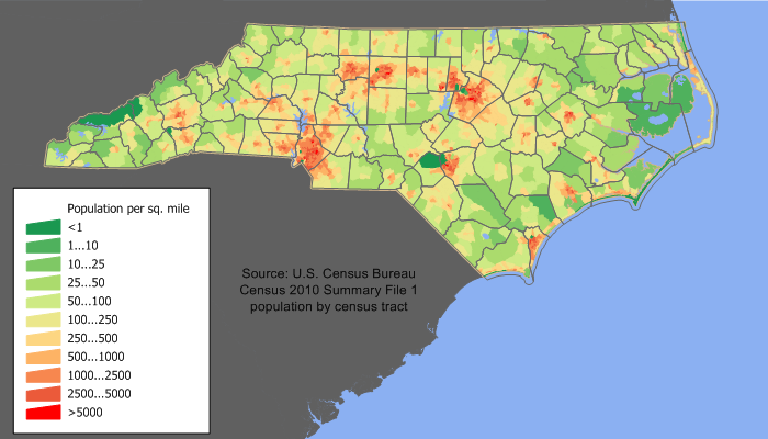
| Description | North Carolina population density map based on Census 2010 data | ||||||||
| Date | see history | ||||||||
| Source | w:en:User:JimIrwin | ||||||||
| Author | w:en:User:JimIrwin | ||||||||
| Permission ( Reusing this file) |
JimIrwin at the
English-language Wikipedia, the copyright holder of this work, hereby publishes it under the following license:
|

Uploaded Originally on EN WP by w:en:User:JimIrwin. 700×450 (37,416 bytes) (North Carolina population density map based on Census 2010 data. See the data lineage for the process description.)
File history
Click on a date/time to view the file as it appeared at that time.
| Date/Time | Thumbnail | Dimensions | User | Comment | |
|---|---|---|---|---|---|
| current | 14:28, 11 December 2011 |
| 700 × 400 (171 KB) | JimIrwin | 2010 census update |
| 18:20, 9 August 2007 |
 | 700 × 450 (37 KB) | Lord Anubis | {{PD-user-w|en|English Wikipedia|JimIrwin}} Uploaded Originally on EN WP by w:en:User:JimIrwin. 700×450 (37,416 bytes) (North Carolina population density map based on Census 2000 data. See the [[:w:en:User:JimIrwin/Lineage_of_population_maps|data l |
File usage
Global file usage
The following other wikis use this file:
- Usage on ar.wikipedia.org
- Usage on cs.wikipedia.org
- Usage on cy.wikipedia.org
- Usage on da.wikipedia.org
- Usage on de.wikipedia.org
- Usage on es.wikipedia.org
- Usage on fr.wikipedia.org
- Usage on gl.wikipedia.org
- Usage on he.wikipedia.org
- Usage on hr.wikipedia.org
- Usage on hu.wikipedia.org
- Usage on incubator.wikimedia.org
- Usage on pl.wikipedia.org
- Usage on ro.wikipedia.org
- Usage on ru.wikipedia.org
- Usage on sh.wikipedia.org
- Usage on sk.wikipedia.org
- Usage on ur.wikipedia.org
- Usage on zh.wikipedia.org
North_Carolina_population_map.png (700 × 400 pixels, file size: 171 KB, MIME type: image/png)
| This is a file from the
Wikimedia Commons. Information from its
description page there is shown below. Commons is a freely licensed media file repository. You can help. |
| Description | North Carolina population density map based on Census 2010 data | ||||||||
| Date | see history | ||||||||
| Source | w:en:User:JimIrwin | ||||||||
| Author | w:en:User:JimIrwin | ||||||||
| Permission ( Reusing this file) |
JimIrwin at the
English-language Wikipedia, the copyright holder of this work, hereby publishes it under the following license:
|
Uploaded Originally on EN WP by w:en:User:JimIrwin. 700×450 (37,416 bytes) (North Carolina population density map based on Census 2010 data. See the data lineage for the process description.)
File history
Click on a date/time to view the file as it appeared at that time.
| Date/Time | Thumbnail | Dimensions | User | Comment | |
|---|---|---|---|---|---|
| current | 14:28, 11 December 2011 |
| 700 × 400 (171 KB) | JimIrwin | 2010 census update |
| 18:20, 9 August 2007 |
| 700 × 450 (37 KB) | Lord Anubis | {{PD-user-w|en|English Wikipedia|JimIrwin}} Uploaded Originally on EN WP by w:en:User:JimIrwin. 700×450 (37,416 bytes) (North Carolina population density map based on Census 2000 data. See the [[:w:en:User:JimIrwin/Lineage_of_population_maps|data l |
File usage
Global file usage
The following other wikis use this file:
- Usage on ar.wikipedia.org
- Usage on cs.wikipedia.org
- Usage on cy.wikipedia.org
- Usage on da.wikipedia.org
- Usage on de.wikipedia.org
- Usage on es.wikipedia.org
- Usage on fr.wikipedia.org
- Usage on gl.wikipedia.org
- Usage on he.wikipedia.org
- Usage on hr.wikipedia.org
- Usage on hu.wikipedia.org
- Usage on incubator.wikimedia.org
- Usage on pl.wikipedia.org
- Usage on ro.wikipedia.org
- Usage on ru.wikipedia.org
- Usage on sh.wikipedia.org
- Usage on sk.wikipedia.org
- Usage on ur.wikipedia.org
- Usage on zh.wikipedia.org