No higher resolution available.
Missouri_population_map_(2000).png (660 × 490 pixels, file size: 33 KB, MIME type: image/png)
| This is a file from the
Wikimedia Commons. Information from its
description page there is shown below. Commons is a freely licensed media file repository. You can help. |
.png)
Summary
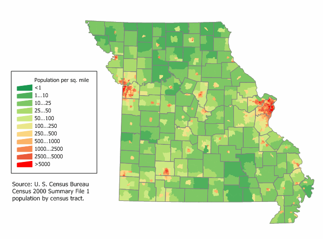
| Description |
English: Missouri state population density map based on Census 2000 data. See the
data lineage for a process description. |
| Date | 12 March 2006 (original upload date) |
| Source | |
| Author | User:JimIrwin |
Licensing
JimIrwin at the
English-language Wikipedia, the copyright holder of this work, hereby publishes it under the following license:

|
Permission is granted to copy, distribute and/or modify this document under the terms of the GNU Free Documentation License, Version 1.2 or any later version published by the Free Software Foundation; with no Invariant Sections, no Front-Cover Texts, and no Back-Cover Texts. A copy of the license is included in the section entitled GNU Free Documentation License. |
| This file is licensed under the Creative Commons Attribution-Share Alike 3.0 Unported license. | ||
| Attribution: JimIrwin | ||
| ||
| This licensing tag was added to this file as part of the GFDL licensing update. |
Original upload log
Transferred from en.wikipedia to Commons using For the Common Good.
The original description page was
here. All following user names refer to en.wikipedia.
| Date/Time | Dimensions | User | Comment |
|---|---|---|---|
| 12:45, 12 March 2006 | 660 × 490 (34,164 bytes) | w:en:JimIrwin ( talk | contribs) | [[Category:U.S. State Population Maps]] [[Category:Missouri maps]] [[Category:United States state population maps]] [[Category:Population maps of the United States]] [[Category:Maps of Missouri]] [[Category:Population density maps of the United States]] |} [[Category:Images of maps without source]] |
File history
Click on a date/time to view the file as it appeared at that time.
| Date/Time | Thumbnail | Dimensions | User | Comment | |
|---|---|---|---|---|---|
| current | 12:45, 21 October 2013 |
| 660 × 490 (33 KB) | Fulvio314 | Transferred from en.wikipedia: see original upload log above |
File usage
The following pages on the English Wikipedia use this file (pages on other projects are not listed):
Global file usage
The following other wikis use this file:
Metadata
.png)
No higher resolution available.
Missouri_population_map_(2000).png (660 × 490 pixels, file size: 33 KB, MIME type: image/png)
| This is a file from the
Wikimedia Commons. Information from its
description page there is shown below. Commons is a freely licensed media file repository. You can help. |
Summary
| Description |
English: Missouri state population density map based on Census 2000 data. See the
data lineage for a process description. |
| Date | 12 March 2006 (original upload date) |
| Source | |
| Author | User:JimIrwin |
Licensing
JimIrwin at the
English-language Wikipedia, the copyright holder of this work, hereby publishes it under the following license:
|
|
Permission is granted to copy, distribute and/or modify this document under the terms of the GNU Free Documentation License, Version 1.2 or any later version published by the Free Software Foundation; with no Invariant Sections, no Front-Cover Texts, and no Back-Cover Texts. A copy of the license is included in the section entitled GNU Free Documentation License. |
| This file is licensed under the Creative Commons Attribution-Share Alike 3.0 Unported license. | ||
| Attribution: JimIrwin | ||
| ||
| This licensing tag was added to this file as part of the GFDL licensing update. |
Original upload log
Transferred from en.wikipedia to Commons using For the Common Good.
The original description page was
here. All following user names refer to en.wikipedia.
| Date/Time | Dimensions | User | Comment |
|---|---|---|---|
| 12:45, 12 March 2006 | 660 × 490 (34,164 bytes) | w:en:JimIrwin ( talk | contribs) | [[Category:U.S. State Population Maps]] [[Category:Missouri maps]] [[Category:United States state population maps]] [[Category:Population maps of the United States]] [[Category:Maps of Missouri]] [[Category:Population density maps of the United States]] |} [[Category:Images of maps without source]] |
File history
Click on a date/time to view the file as it appeared at that time.
| Date/Time | Thumbnail | Dimensions | User | Comment | |
|---|---|---|---|---|---|
| current | 12:45, 21 October 2013 |
| 660 × 490 (33 KB) | Fulvio314 | Transferred from en.wikipedia: see original upload log above |
File usage
The following pages on the English Wikipedia use this file (pages on other projects are not listed):
Global file usage
The following other wikis use this file: