
Size of this PNG preview of this SVG file:
513 × 599 pixels. Other resolutions:
205 × 240 pixels |
411 × 480 pixels |
658 × 768 pixels |
877 × 1,024 pixels |
1,754 × 2,048 pixels |
1,251 × 1,461 pixels.
Original file (SVG file, nominally 1,251 × 1,461 pixels, file size: 923 KB)
| This is a file from the
Wikimedia Commons. Information from its
description page there is shown below. Commons is a freely licensed media file repository. You can help. |
Summary
| Description |
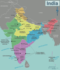
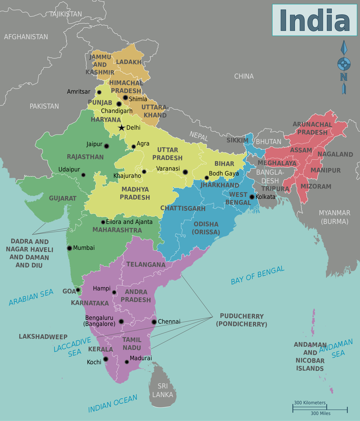
English: Map of India. A map of India's regions, states and metropolis', India
|
| Date | |
| Source | Own work based on: India-states-numbered.svg |
| Author | Cacahuate, Ravikiran Rao, Nichalp (base outline) |
| Other versions |
PNG versions: |
| SVG development |

.png)
.png)
Licensing
This file is licensed under the
Creative Commons Attribution-Share Alike
4.0 International,
3.0 Unported,
2.5 Generic,
2.0 Generic and
1.0 Generic license.
- You are free:
- to share – to copy, distribute and transmit the work
- to remix – to adapt the work
- Under the following conditions:
- attribution – You must give appropriate credit, provide a link to the license, and indicate if changes were made. You may do so in any reasonable manner, but not in any way that suggests the licensor endorses you or your use.
- share alike – If you remix, transform, or build upon the material, you must distribute your contributions under the same or compatible license as the original.
|
|
Warning! According to Indian law, it is illegal to produce maps that in the view of the Indian government, misrepresent Indian territories by showing areas the Indian government claims ownership of but does not control as not belonging to India or as being contested. |
Original upload log
|
|
This file was imported from Wikivoyage WTS. |
The original description page was
here. All following user names refer to wts.wikivoyage-old.
- 2009-08-22 20:29 (WT-shared) Cacahuate dead link 744×1052 (934778 bytes) == Summary == {{Imagecredit|credit=[[User:Cacahuate|Cacahuate]], [[User:Mark|Mark]] (WT logo), [[:commons:User:Nichalp|Nichalp]] (base outli (Import from wikitravel.org/shared)
- 2009-08-25 05:42 (WT-shared) Ravikiranr dead link 744×1052 (957587 bytes) (Import from wikitravel.org/shared)
- 2009-08-25 20:07 (WT-shared) Cacahuate dead link 744×1052 (931860 bytes) Update fonts to DejaVu Sans Condensed (Import from wikitravel.org/shared)
- 2011-10-22 23:00 (WT-shared) Joelf dead link 1251×1461 (868042 bytes) +fr (Import from wikitravel.org/shared)
- 2012-09-11 16:18 Atsirlin dead link 1251×1461 (951593 bytes) +ru, cleanup
File history
Click on a date/time to view the file as it appeared at that time.
| Date/Time | Thumbnail | Dimensions | User | Comment | |
|---|---|---|---|---|---|
| current | 14:38, 16 January 2021 |
| 1,251 × 1,461 (923 KB) | Sbb1413 | Updated to include new jurisdictions, plus the addition of union territories. |
| 12:58, 25 January 2016 |
 | 1,251 × 1,461 (939 KB) | Csyogi | Telangana state update | |
| 10:16, 15 December 2013 |
 | 1,251 × 1,461 (931 KB) | Saqib | typo | |
| 22:14, 8 June 2013 |
 | 1,251 × 1,461 (931 KB) | Saqib | removed hatching | |
| 18:05, 15 December 2012 |
 | 1,251 × 1,461 (929 KB) | OgreBot | (BOT): Reverting to most recent version before archival | |
| 18:04, 15 December 2012 |
 | 1,251 × 1,461 (848 KB) | OgreBot | (BOT): Uploading old version of file from wts.wikivoyage; originally uploaded on 2011-10-22 23:00:45 by (WT-shared) Joelf | |
| 18:04, 15 December 2012 |
 | 744 × 1,052 (910 KB) | OgreBot | (BOT): Uploading old version of file from wts.wikivoyage; originally uploaded on 2009-08-25 20:07:33 by (WT-shared) Cacahuate | |
| 18:04, 15 December 2012 |
 | 744 × 1,052 (935 KB) | OgreBot | (BOT): Uploading old version of file from wts.wikivoyage; originally uploaded on 2009-08-25 05:42:19 by (WT-shared) Ravikiranr | |
| 18:04, 15 December 2012 |
 | 744 × 1,052 (913 KB) | OgreBot | (BOT): Uploading old version of file from wts.wikivoyage; originally uploaded on 2009-08-22 20:29:43 by (WT-shared) Cacahuate | |
| 21:52, 25 November 2012 |
 | 1,251 × 1,461 (929 KB) | MGA73bot2 | {{BotMoveToCommons|wts.oldwikivoyage|year={{subst:CURRENTYEAR}}|month={{subst:CURRENTMONTHNAME}}|day={{subst:CURRENTDAY}}}} == {{int:filedesc}} == {{Information |description=Map of India. A map of India's regions, states and metropolis', India * Map of... |
File usage
The following pages on the English Wikipedia use this file (pages on other projects are not listed):
Global file usage
The following other wikis use this file:
- Usage on nl.wikivoyage.org
Metadata
Size of this PNG preview of this SVG file:
513 × 599 pixels. Other resolutions:
205 × 240 pixels |
411 × 480 pixels |
658 × 768 pixels |
877 × 1,024 pixels |
1,754 × 2,048 pixels |
1,251 × 1,461 pixels.
Original file (SVG file, nominally 1,251 × 1,461 pixels, file size: 923 KB)
| This is a file from the
Wikimedia Commons. Information from its
description page there is shown below. Commons is a freely licensed media file repository. You can help. |
Summary
| Description |
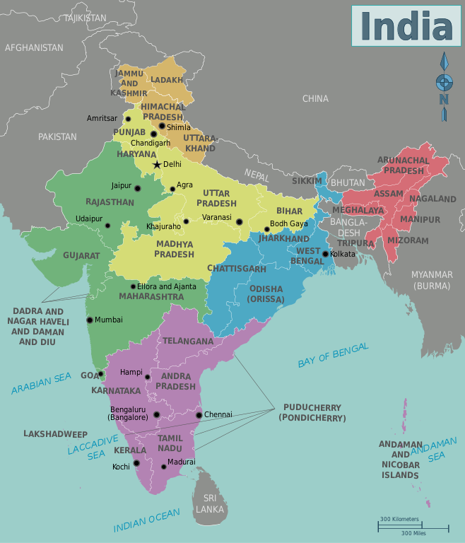
English: Map of India. A map of India's regions, states and metropolis', India
|
| Date | |
| Source | Own work based on: India-states-numbered.svg |
| Author | Cacahuate, Ravikiran Rao, Nichalp (base outline) |
| Other versions |
PNG versions: |
| SVG development |
Licensing
This file is licensed under the
Creative Commons Attribution-Share Alike
4.0 International,
3.0 Unported,
2.5 Generic,
2.0 Generic and
1.0 Generic license.
- You are free:
- to share – to copy, distribute and transmit the work
- to remix – to adapt the work
- Under the following conditions:
- attribution – You must give appropriate credit, provide a link to the license, and indicate if changes were made. You may do so in any reasonable manner, but not in any way that suggests the licensor endorses you or your use.
- share alike – If you remix, transform, or build upon the material, you must distribute your contributions under the same or compatible license as the original.
|
|
Warning! According to Indian law, it is illegal to produce maps that in the view of the Indian government, misrepresent Indian territories by showing areas the Indian government claims ownership of but does not control as not belonging to India or as being contested. |
Original upload log
|
|
This file was imported from Wikivoyage WTS. |
The original description page was
here. All following user names refer to wts.wikivoyage-old.
- 2009-08-22 20:29 (WT-shared) Cacahuate dead link 744×1052 (934778 bytes) == Summary == {{Imagecredit|credit=[[User:Cacahuate|Cacahuate]], [[User:Mark|Mark]] (WT logo), [[:commons:User:Nichalp|Nichalp]] (base outli (Import from wikitravel.org/shared)
- 2009-08-25 05:42 (WT-shared) Ravikiranr dead link 744×1052 (957587 bytes) (Import from wikitravel.org/shared)
- 2009-08-25 20:07 (WT-shared) Cacahuate dead link 744×1052 (931860 bytes) Update fonts to DejaVu Sans Condensed (Import from wikitravel.org/shared)
- 2011-10-22 23:00 (WT-shared) Joelf dead link 1251×1461 (868042 bytes) +fr (Import from wikitravel.org/shared)
- 2012-09-11 16:18 Atsirlin dead link 1251×1461 (951593 bytes) +ru, cleanup
File history
Click on a date/time to view the file as it appeared at that time.
| Date/Time | Thumbnail | Dimensions | User | Comment | |
|---|---|---|---|---|---|
| current | 14:38, 16 January 2021 |
| 1,251 × 1,461 (923 KB) | Sbb1413 | Updated to include new jurisdictions, plus the addition of union territories. |
| 12:58, 25 January 2016 |
| 1,251 × 1,461 (939 KB) | Csyogi | Telangana state update | |
| 10:16, 15 December 2013 |
| 1,251 × 1,461 (931 KB) | Saqib | typo | |
| 22:14, 8 June 2013 |
| 1,251 × 1,461 (931 KB) | Saqib | removed hatching | |
| 18:05, 15 December 2012 |
| 1,251 × 1,461 (929 KB) | OgreBot | (BOT): Reverting to most recent version before archival | |
| 18:04, 15 December 2012 |
| 1,251 × 1,461 (848 KB) | OgreBot | (BOT): Uploading old version of file from wts.wikivoyage; originally uploaded on 2011-10-22 23:00:45 by (WT-shared) Joelf | |
| 18:04, 15 December 2012 |
| 744 × 1,052 (910 KB) | OgreBot | (BOT): Uploading old version of file from wts.wikivoyage; originally uploaded on 2009-08-25 20:07:33 by (WT-shared) Cacahuate | |
| 18:04, 15 December 2012 |
| 744 × 1,052 (935 KB) | OgreBot | (BOT): Uploading old version of file from wts.wikivoyage; originally uploaded on 2009-08-25 05:42:19 by (WT-shared) Ravikiranr | |
| 18:04, 15 December 2012 |
| 744 × 1,052 (913 KB) | OgreBot | (BOT): Uploading old version of file from wts.wikivoyage; originally uploaded on 2009-08-22 20:29:43 by (WT-shared) Cacahuate | |
| 21:52, 25 November 2012 |
| 1,251 × 1,461 (929 KB) | MGA73bot2 | {{BotMoveToCommons|wts.oldwikivoyage|year={{subst:CURRENTYEAR}}|month={{subst:CURRENTMONTHNAME}}|day={{subst:CURRENTDAY}}}} == {{int:filedesc}} == {{Information |description=Map of India. A map of India's regions, states and metropolis', India * Map of... |
File usage
The following pages on the English Wikipedia use this file (pages on other projects are not listed):
Global file usage
The following other wikis use this file:
- Usage on nl.wikivoyage.org