Size of this preview:
800 × 570 pixels. Other resolutions:
320 × 228 pixels |
640 × 456 pixels |
1,024 × 729 pixels |
1,280 × 911 pixels |
1,438 × 1,024 pixels.
Original file (1,438 × 1,024 pixels, file size: 318 KB, MIME type: image/jpeg)
| This is a file from the
Wikimedia Commons. Information from its
description page there is shown below. Commons is a freely licensed media file repository. You can help. |
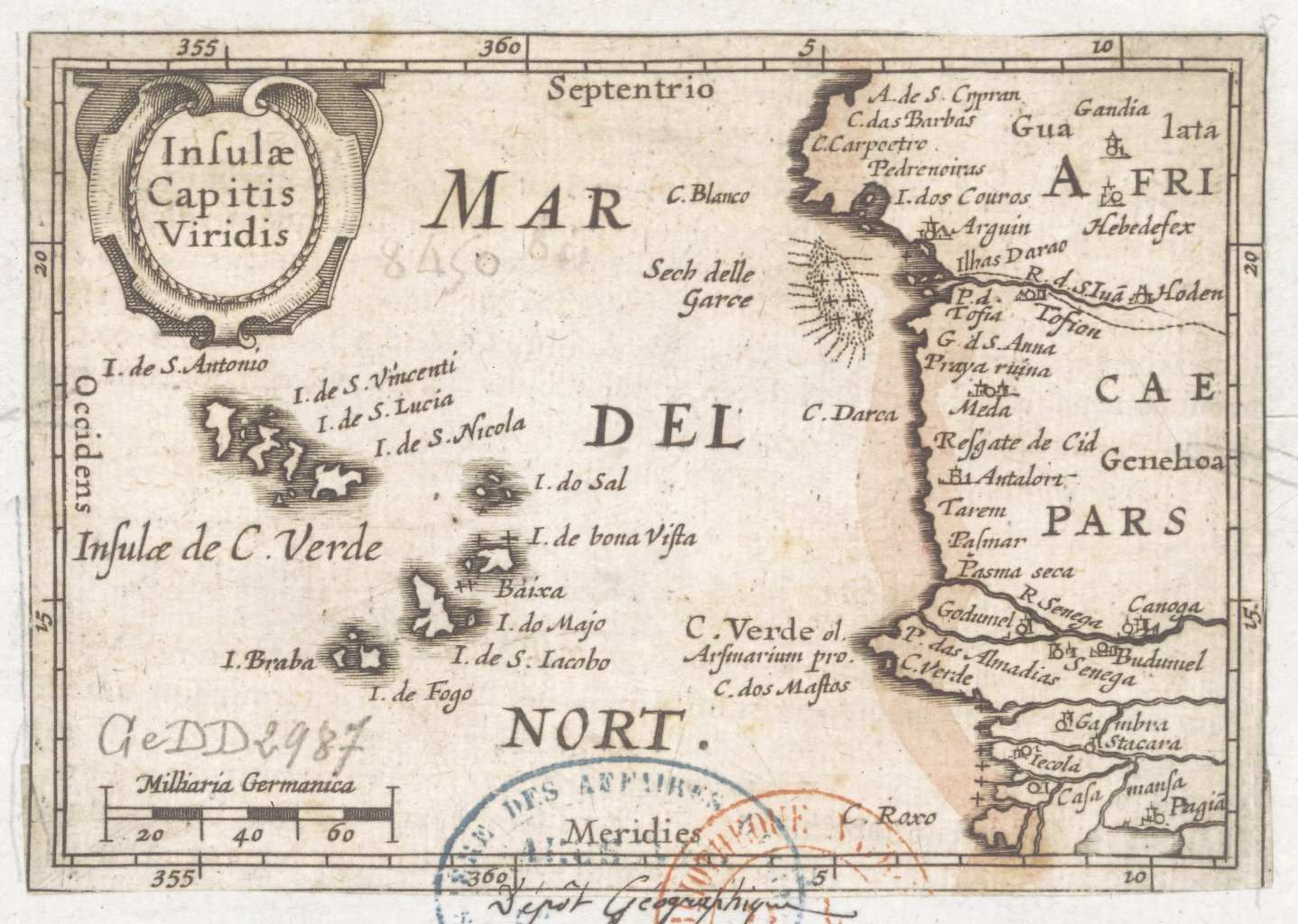
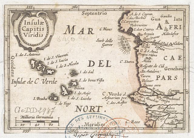
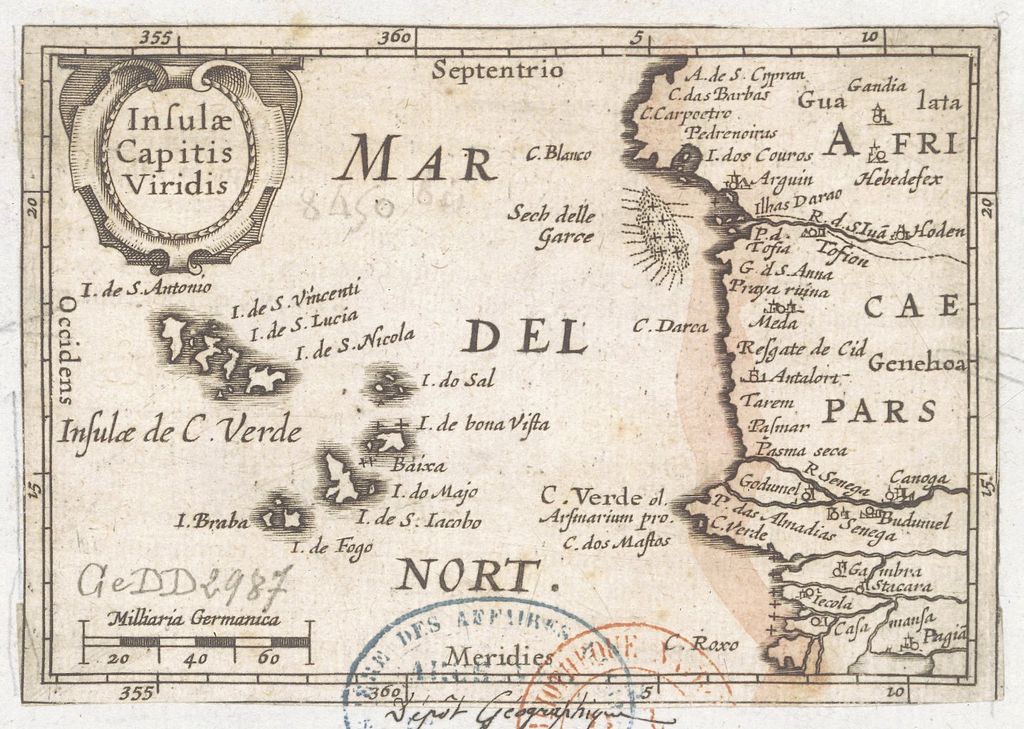
| Description | Insulae Capitis viridis |
| Date | |
| Source |
Bibliothèque nationale de France |
| Author | Langenes, Barent (15..-16..?). Cartographe |
| Previous public domain rationale, no longer applicable | ||
|---|---|---|
|
File history
Click on a date/time to view the file as it appeared at that time.
| Date/Time | Thumbnail | Dimensions | User | Comment | |
|---|---|---|---|---|---|
| current | 08:01, 5 February 2013 |
| 1,438 × 1,024 (318 KB) | Geagea | large |
| 07:20, 22 March 2010 |
 | 719 × 542 (75 KB) | Ji-Elle | {{Information |Description=''Insulae Capitis viridis'' |Source=Gallica [http://gallica.bnf.fr/ark:/12148/btv1b7759743x] |Date=1598 |Author=Langenes, Barent (15..-16..?). Cartographe |Permission= |other_versions= }} [[Category:Maps made in the 16th centur |
File usage
The following pages on the English Wikipedia use this file (pages on other projects are not listed):
Global file usage
The following other wikis use this file:
- Usage on ca.wikipedia.org
- Usage on es.wikipedia.org
- Usage on fi.wikipedia.org
- Usage on fr.wikipedia.org
- Usage on id.wikipedia.org
- Usage on io.wikipedia.org
- Usage on ja.wikipedia.org
- Usage on nl.wikipedia.org
- Usage on no.wikipedia.org
- Usage on sd.wikipedia.org
- Usage on si.wikipedia.org
- Usage on sv.wikipedia.org
- Usage on te.wikipedia.org
Size of this preview:
800 × 570 pixels. Other resolutions:
320 × 228 pixels |
640 × 456 pixels |
1,024 × 729 pixels |
1,280 × 911 pixels |
1,438 × 1,024 pixels.
Original file (1,438 × 1,024 pixels, file size: 318 KB, MIME type: image/jpeg)
| This is a file from the
Wikimedia Commons. Information from its
description page there is shown below. Commons is a freely licensed media file repository. You can help. |
| Description | Insulae Capitis viridis |
| Date | |
| Source |
Bibliothèque nationale de France |
| Author | Langenes, Barent (15..-16..?). Cartographe |
| Previous public domain rationale, no longer applicable | ||
|---|---|---|
|
File history
Click on a date/time to view the file as it appeared at that time.
| Date/Time | Thumbnail | Dimensions | User | Comment | |
|---|---|---|---|---|---|
| current | 08:01, 5 February 2013 |
| 1,438 × 1,024 (318 KB) | Geagea | large |
| 07:20, 22 March 2010 |
| 719 × 542 (75 KB) | Ji-Elle | {{Information |Description=''Insulae Capitis viridis'' |Source=Gallica [http://gallica.bnf.fr/ark:/12148/btv1b7759743x] |Date=1598 |Author=Langenes, Barent (15..-16..?). Cartographe |Permission= |other_versions= }} [[Category:Maps made in the 16th centur |
File usage
The following pages on the English Wikipedia use this file (pages on other projects are not listed):
Global file usage
The following other wikis use this file:
- Usage on ca.wikipedia.org
- Usage on es.wikipedia.org
- Usage on fi.wikipedia.org
- Usage on fr.wikipedia.org
- Usage on id.wikipedia.org
- Usage on io.wikipedia.org
- Usage on ja.wikipedia.org
- Usage on nl.wikipedia.org
- Usage on no.wikipedia.org
- Usage on sd.wikipedia.org
- Usage on si.wikipedia.org
- Usage on sv.wikipedia.org
- Usage on te.wikipedia.org