Size of this preview:
800 × 431 pixels. Other resolutions:
320 × 173 pixels |
640 × 345 pixels |
1,024 × 552 pixels |
1,280 × 690 pixels |
2,560 × 1,380 pixels |
4,000 × 2,157 pixels.
Original file (4,000 × 2,157 pixels, file size: 2.55 MB, MIME type: image/png)
| This is a file from the
Wikimedia Commons. Information from its
description page there is shown below. Commons is a freely licensed media file repository. You can help. |

|
This map image could be re-created using
vector graphics as an
SVG file. This has several advantages; see
Commons:Media for cleanup for more information. If an SVG form of this image is available, please upload it and afterwards replace this template with
{{
vector version available|new image name}}
.
It is recommended to name the SVG file “Hungary 1941-44 Administrative Map.svg”—then the template Vector version available (or Vva) does not need the new image name parameter. |
Summary
| Description |
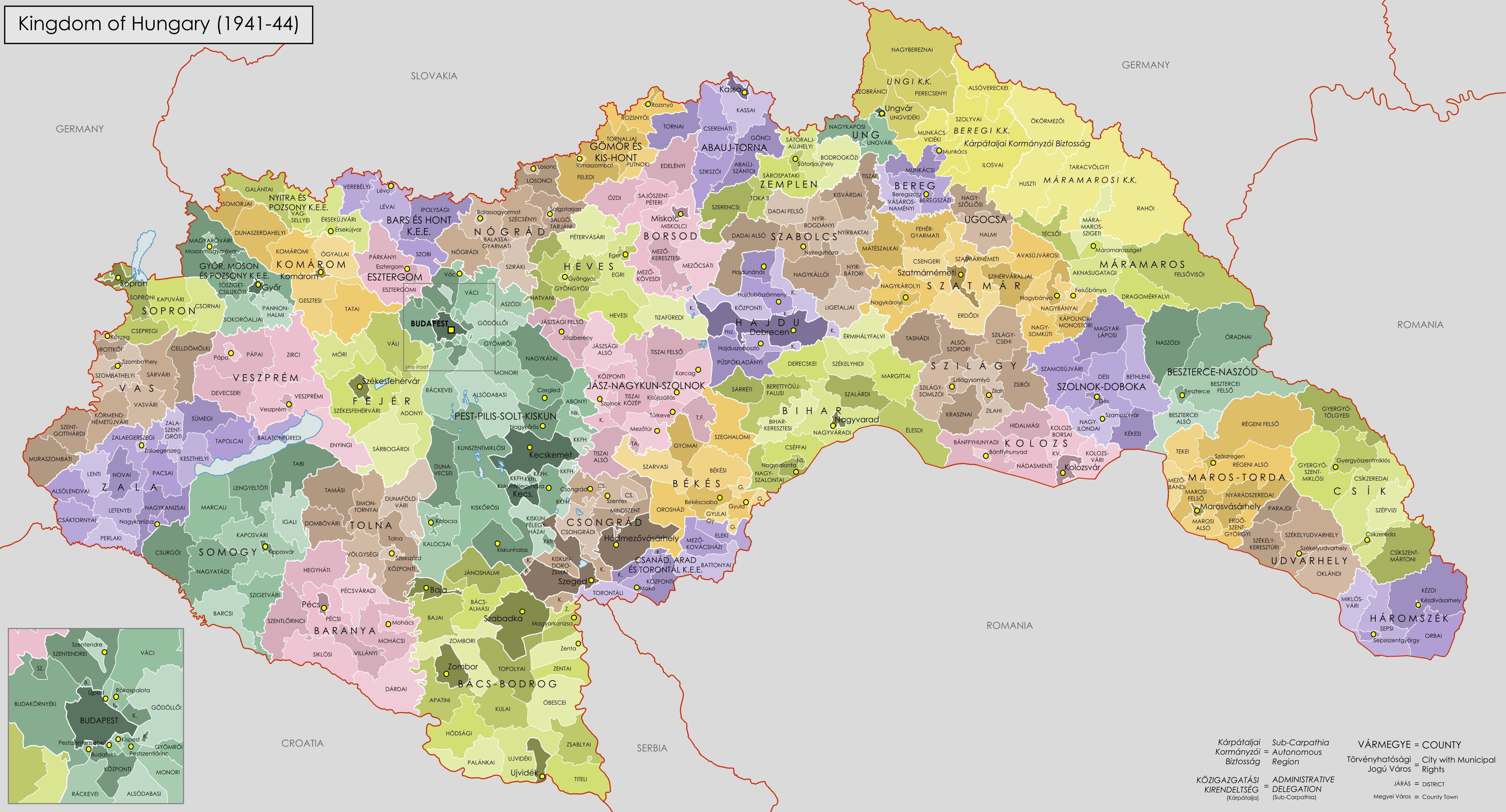
English: Administrative Map of the Kingdom of Hungary from 1941-44. |
| Date | |
| Source |
Own work using:
|
| Author | XrysD |
Licensing
I, the copyright holder of this work, hereby publish it under the following licenses:

|
Permission is granted to copy, distribute and/or modify this document under the terms of the GNU Free Documentation License, Version 1.2 or any later version published by the Free Software Foundation; with no Invariant Sections, no Front-Cover Texts, and no Back-Cover Texts. A copy of the license is included in the section entitled GNU Free Documentation License. |
| This file is licensed under the Creative Commons Attribution-Share Alike 3.0 Unported license. | ||
| ||
| This licensing tag was added to this file as part of the GFDL licensing update. |
You may select the license of your choice.
File history
Click on a date/time to view the file as it appeared at that time.
| Date/Time | Thumbnail | Dimensions | User | Comment | |
|---|---|---|---|---|---|
| current | 18:04, 25 August 2016 |
| 4,000 × 2,157 (2.55 MB) | XrysD | Fixed typo for Hajduböszörmeny (thanks Tunde). |
| 12:40, 11 April 2009 |
 | 4,000 × 2,157 (2.58 MB) | XrysD | Borders edited to be more accurate and spelling mistakes corrected | |
| 21:15, 18 January 2009 |
 | 4,000 × 2,215 (2.47 MB) | XrysD | {{Information |Description= |Source= |Date= |Author= |Permission= |other_versions= }} | |
| 20:50, 18 January 2009 |
 | 4,940 × 2,736 (3.18 MB) | XrysD | {{Information |Description={{en|1=Administrative Map of the Kingdom of Hungary from 1941-44.}} |Source=Own work by uploader |Author= XrysD |Date=18/01/2009 |Permission= |other_versions= }} <!--{{ImageUpload|full}}--> |
File usage
The following pages on the English Wikipedia use this file (pages on other projects are not listed):
Global file usage
The following other wikis use this file:
- Usage on azb.wikipedia.org
- Usage on bn.wikipedia.org
- Usage on cy.wikipedia.org
- Usage on de.wikipedia.org
- Usage on eu.wikipedia.org
- Usage on fr.wikipedia.org
- Usage on hu.wikipedia.org
- Usage on hy.wikipedia.org
- Usage on id.wikipedia.org
- Usage on it.wikipedia.org
- Usage on ja.wikipedia.org
- Usage on mk.wikipedia.org
- Usage on nl.wikipedia.org
- Usage on pl.wikipedia.org
- Usage on pt.wikipedia.org
- Usage on ro.wikipedia.org
- Usage on ru.wikipedia.org
- Usage on sh.wikipedia.org
- Usage on sl.wikipedia.org
- Usage on sr.wikipedia.org
- Usage on te.wikipedia.org
- Usage on th.wikipedia.org
- Usage on uk.wikipedia.org
- Usage on zh.wikipedia.org
Metadata
Size of this preview:
800 × 431 pixels. Other resolutions:
320 × 173 pixels |
640 × 345 pixels |
1,024 × 552 pixels |
1,280 × 690 pixels |
2,560 × 1,380 pixels |
4,000 × 2,157 pixels.
Original file (4,000 × 2,157 pixels, file size: 2.55 MB, MIME type: image/png)
| This is a file from the
Wikimedia Commons. Information from its
description page there is shown below. Commons is a freely licensed media file repository. You can help. |
|
|
This map image could be re-created using
vector graphics as an
SVG file. This has several advantages; see
Commons:Media for cleanup for more information. If an SVG form of this image is available, please upload it and afterwards replace this template with
{{
vector version available|new image name}}
.
It is recommended to name the SVG file “Hungary 1941-44 Administrative Map.svg”—then the template Vector version available (or Vva) does not need the new image name parameter. |
Summary
| Description |
English: Administrative Map of the Kingdom of Hungary from 1941-44. |
| Date | |
| Source |
Own work using:
|
| Author | XrysD |
Licensing
I, the copyright holder of this work, hereby publish it under the following licenses:
|
|
Permission is granted to copy, distribute and/or modify this document under the terms of the GNU Free Documentation License, Version 1.2 or any later version published by the Free Software Foundation; with no Invariant Sections, no Front-Cover Texts, and no Back-Cover Texts. A copy of the license is included in the section entitled GNU Free Documentation License. |
| This file is licensed under the Creative Commons Attribution-Share Alike 3.0 Unported license. | ||
| ||
| This licensing tag was added to this file as part of the GFDL licensing update. |
You may select the license of your choice.
File history
Click on a date/time to view the file as it appeared at that time.
| Date/Time | Thumbnail | Dimensions | User | Comment | |
|---|---|---|---|---|---|
| current | 18:04, 25 August 2016 |
| 4,000 × 2,157 (2.55 MB) | XrysD | Fixed typo for Hajduböszörmeny (thanks Tunde). |
| 12:40, 11 April 2009 |
| 4,000 × 2,157 (2.58 MB) | XrysD | Borders edited to be more accurate and spelling mistakes corrected | |
| 21:15, 18 January 2009 |
| 4,000 × 2,215 (2.47 MB) | XrysD | {{Information |Description= |Source= |Date= |Author= |Permission= |other_versions= }} | |
| 20:50, 18 January 2009 |
| 4,940 × 2,736 (3.18 MB) | XrysD | {{Information |Description={{en|1=Administrative Map of the Kingdom of Hungary from 1941-44.}} |Source=Own work by uploader |Author= XrysD |Date=18/01/2009 |Permission= |other_versions= }} <!--{{ImageUpload|full}}--> |
File usage
The following pages on the English Wikipedia use this file (pages on other projects are not listed):
Global file usage
The following other wikis use this file:
- Usage on azb.wikipedia.org
- Usage on bn.wikipedia.org
- Usage on cy.wikipedia.org
- Usage on de.wikipedia.org
- Usage on eu.wikipedia.org
- Usage on fr.wikipedia.org
- Usage on hu.wikipedia.org
- Usage on hy.wikipedia.org
- Usage on id.wikipedia.org
- Usage on it.wikipedia.org
- Usage on ja.wikipedia.org
- Usage on mk.wikipedia.org
- Usage on nl.wikipedia.org
- Usage on pl.wikipedia.org
- Usage on pt.wikipedia.org
- Usage on ro.wikipedia.org
- Usage on ru.wikipedia.org
- Usage on sh.wikipedia.org
- Usage on sl.wikipedia.org
- Usage on sr.wikipedia.org
- Usage on te.wikipedia.org
- Usage on th.wikipedia.org
- Usage on uk.wikipedia.org
- Usage on zh.wikipedia.org