
Size of this PNG preview of this SVG file:
713 × 600 pixels. Other resolutions:
285 × 240 pixels |
571 × 480 pixels |
913 × 768 pixels |
1,218 × 1,024 pixels |
2,435 × 2,048 pixels |
2,045 × 1,720 pixels.
Original file (SVG file, nominally 2,045 × 1,720 pixels, file size: 7.73 MB)
| This is a file from the
Wikimedia Commons. Information from its
description page there is shown below. Commons is a freely licensed media file repository. You can help. |
Summary
| Description |
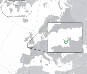
English: The Full Map of Jersey |
||
| Date | |||
| Source |
Own work based on:
Europe-Northern Cyprus.svg and
Europe-Serbia.svg
|
||
| Author | Chipmunkdavis | ||
| Other versions |
Derivative works of this file: |
||
| SVG development |
|

Licensing
This file is licensed under the
Creative Commons
Attribution-Share Alike 3.0 Unported license.
- You are free:
- to share – to copy, distribute and transmit the work
- to remix – to adapt the work
- Under the following conditions:
- attribution – You must give appropriate credit, provide a link to the license, and indicate if changes were made. You may do so in any reasonable manner, but not in any way that suggests the licensor endorses you or your use.
- share alike – If you remix, transform, or build upon the material, you must distribute your contributions under the same or compatible license as the original.
Original upload log
This image is a derivative work of the following images:
-
Europe-Northern Cyprus.svg licensed with Cc-by-3.0
- 2011-02-20T17:16:12Z Chipmunkdavis 2045x1720 (2331880 Bytes) {{Information |Description={{en|1={{Europe-SVG-en|Northern Cyprus}}}} |Source=*[[:File:Europe-Serbia.svg|]] |Date=2011-02-20 17:14 (UTC) |Author=*[[:File:Europe-Serbia.svg|]]: {{click|image=TheEmirr-Logo.png|link=User:The Emi
-
Jersey Map.svg licensed with PD-self
- 2009-04-02T01:46:41Z Ichwan Palongengi 626x433 (208689 Bytes) Remove the flaw...
- 2009-04-02T01:39:59Z Ichwan Palongengi 626x433 (207980 Bytes) {{Information |Description={{en|1=The Full Map of Jersey}} |Source=Own work by uploader |Author=[[User:Ichwan Palongengi|Ichwan Palongengi]] |Date=2009-03-01 |Permission= |other_versions= }} [[Category:Jersey]]
Uploaded with derivativeFX
File history
Click on a date/time to view the file as it appeared at that time.
| Date/Time | Thumbnail | Dimensions | User | Comment | |
|---|---|---|---|---|---|
| current | 01:57, 8 November 2017 |
| 2,045 × 1,720 (7.73 MB) | Rob984 | Added circle like the original |
| 00:35, 8 November 2017 |
 | 2,045 × 1,720 (7.73 MB) | Rob984 | Modified to try to better locate the island both within the Channel and Europe (so multiple maps aren't needed) | |
| 07:49, 21 February 2011 |
 | 2,045 × 1,720 (2.28 MB) | Chipmunkdavis | {{Information |Description={{en|1={{Europe-SVG-en|Northern Cyprus}}}} {{en|1=The Full Map of Jersey}} |Source=* File:Europe-Northern_Cyprus.svg * File:Jersey_Map.svg |Date=2011-02-21 07:48 (UTC) |Author=* File:Europe-Northern_Cyprus.svg: *[ |
File usage
The following pages on the English Wikipedia use this file (pages on other projects are not listed):
Global file usage
The following other wikis use this file:
- Usage on af.wikipedia.org
- Usage on ang.wikipedia.org
- Usage on ar.wikipedia.org
- Usage on arz.wikipedia.org
- Usage on ast.wikipedia.org
- Usage on azb.wikipedia.org
- Usage on az.wikipedia.org
- Usage on be-tarask.wikipedia.org
- Usage on be.wikipedia.org
- Usage on bh.wikipedia.org
- Usage on bn.wikipedia.org
- Usage on ca.wikipedia.org
- Usage on cdo.wikipedia.org
- Usage on chr.wikipedia.org
- Usage on cs.wikipedia.org
- Usage on da.wikipedia.org
- Usage on diq.wikipedia.org
- Usage on en.wikivoyage.org
- Usage on es.wikipedia.org
- Usage on fa.wikipedia.org
- Usage on fi.wikipedia.org
- Usage on fr.wikipedia.org
- Usage on ga.wikipedia.org
- Usage on gl.wikipedia.org
- Usage on hak.wikipedia.org
- Usage on ha.wikipedia.org
- Usage on he.wikipedia.org
- Usage on he.wikivoyage.org
- Usage on hr.wikipedia.org
- Usage on hy.wikipedia.org
- Usage on ia.wikipedia.org
- Usage on incubator.wikimedia.org
- Usage on is.wikipedia.org
- Usage on it.wikipedia.org
- Usage on ja.wikipedia.org
- Usage on ka.wikipedia.org
- Usage on km.wikipedia.org
View more global usage of this file.
Metadata
Size of this PNG preview of this SVG file:
713 × 600 pixels. Other resolutions:
285 × 240 pixels |
571 × 480 pixels |
913 × 768 pixels |
1,218 × 1,024 pixels |
2,435 × 2,048 pixels |
2,045 × 1,720 pixels.
Original file (SVG file, nominally 2,045 × 1,720 pixels, file size: 7.73 MB)
| This is a file from the
Wikimedia Commons. Information from its
description page there is shown below. Commons is a freely licensed media file repository. You can help. |
Summary
| Description |
English: The Full Map of Jersey |
||
| Date | |||
| Source |
Own work based on:
Europe-Northern Cyprus.svg and
Europe-Serbia.svg
|
||
| Author | Chipmunkdavis | ||
| Other versions |
Derivative works of this file: |
||
| SVG development |
|
Licensing
This file is licensed under the
Creative Commons
Attribution-Share Alike 3.0 Unported license.
- You are free:
- to share – to copy, distribute and transmit the work
- to remix – to adapt the work
- Under the following conditions:
- attribution – You must give appropriate credit, provide a link to the license, and indicate if changes were made. You may do so in any reasonable manner, but not in any way that suggests the licensor endorses you or your use.
- share alike – If you remix, transform, or build upon the material, you must distribute your contributions under the same or compatible license as the original.
Original upload log
This image is a derivative work of the following images:
-
Europe-Northern Cyprus.svg licensed with Cc-by-3.0
- 2011-02-20T17:16:12Z Chipmunkdavis 2045x1720 (2331880 Bytes) {{Information |Description={{en|1={{Europe-SVG-en|Northern Cyprus}}}} |Source=*[[:File:Europe-Serbia.svg|]] |Date=2011-02-20 17:14 (UTC) |Author=*[[:File:Europe-Serbia.svg|]]: {{click|image=TheEmirr-Logo.png|link=User:The Emi
-
Jersey Map.svg licensed with PD-self
- 2009-04-02T01:46:41Z Ichwan Palongengi 626x433 (208689 Bytes) Remove the flaw...
- 2009-04-02T01:39:59Z Ichwan Palongengi 626x433 (207980 Bytes) {{Information |Description={{en|1=The Full Map of Jersey}} |Source=Own work by uploader |Author=[[User:Ichwan Palongengi|Ichwan Palongengi]] |Date=2009-03-01 |Permission= |other_versions= }} [[Category:Jersey]]
Uploaded with derivativeFX
File history
Click on a date/time to view the file as it appeared at that time.
| Date/Time | Thumbnail | Dimensions | User | Comment | |
|---|---|---|---|---|---|
| current | 01:57, 8 November 2017 |
| 2,045 × 1,720 (7.73 MB) | Rob984 | Added circle like the original |
| 00:35, 8 November 2017 |
| 2,045 × 1,720 (7.73 MB) | Rob984 | Modified to try to better locate the island both within the Channel and Europe (so multiple maps aren't needed) | |
| 07:49, 21 February 2011 |
| 2,045 × 1,720 (2.28 MB) | Chipmunkdavis | {{Information |Description={{en|1={{Europe-SVG-en|Northern Cyprus}}}} {{en|1=The Full Map of Jersey}} |Source=* File:Europe-Northern_Cyprus.svg * File:Jersey_Map.svg |Date=2011-02-21 07:48 (UTC) |Author=* File:Europe-Northern_Cyprus.svg: *[ |
File usage
The following pages on the English Wikipedia use this file (pages on other projects are not listed):
Global file usage
The following other wikis use this file:
- Usage on af.wikipedia.org
- Usage on ang.wikipedia.org
- Usage on ar.wikipedia.org
- Usage on arz.wikipedia.org
- Usage on ast.wikipedia.org
- Usage on azb.wikipedia.org
- Usage on az.wikipedia.org
- Usage on be-tarask.wikipedia.org
- Usage on be.wikipedia.org
- Usage on bh.wikipedia.org
- Usage on bn.wikipedia.org
- Usage on ca.wikipedia.org
- Usage on cdo.wikipedia.org
- Usage on chr.wikipedia.org
- Usage on cs.wikipedia.org
- Usage on da.wikipedia.org
- Usage on diq.wikipedia.org
- Usage on en.wikivoyage.org
- Usage on es.wikipedia.org
- Usage on fa.wikipedia.org
- Usage on fi.wikipedia.org
- Usage on fr.wikipedia.org
- Usage on ga.wikipedia.org
- Usage on gl.wikipedia.org
- Usage on hak.wikipedia.org
- Usage on ha.wikipedia.org
- Usage on he.wikipedia.org
- Usage on he.wikivoyage.org
- Usage on hr.wikipedia.org
- Usage on hy.wikipedia.org
- Usage on ia.wikipedia.org
- Usage on incubator.wikimedia.org
- Usage on is.wikipedia.org
- Usage on it.wikipedia.org
- Usage on ja.wikipedia.org
- Usage on ka.wikipedia.org
- Usage on km.wikipedia.org
View more global usage of this file.