
Size of this PNG preview of this SVG file:
713 × 600 pixels. Other resolutions:
285 × 240 pixels |
571 × 480 pixels |
913 × 768 pixels |
1,218 × 1,024 pixels |
2,435 × 2,048 pixels |
2,045 × 1,720 pixels.
Original file (SVG file, nominally 2,045 × 1,720 pixels, file size: 7.33 MB)
| This is a file from the
Wikimedia Commons. Information from its
description page there is shown below. Commons is a freely licensed media file repository. You can help. |
польша
Summary
Polski:
(Green)
Polska.
(Light-green)
Unia Europejska (UE).
(Gray)
Europa.
(Light-gray) Inne terytoria.
| Description |
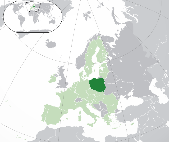
English: (Dark-Green)
Poland. (Light-Green) The rest of the
European Union (EU). (Dark-gray) The rest of
Europe. (Light-gray) The surrounding region.
See also: |
| SVG development | |
| Date | |
| Source | Own work based on: Location European nation states.svg |
| Author | NuclearVacuum |
| Other versions |
|
| SVG development |


Licensing
I, the copyright holder of this work, hereby publish it under the following licenses:
This file is licensed under the
Creative Commons
Attribution-Share Alike 3.0 Unported license.
- You are free:
- to share – to copy, distribute and transmit the work
- to remix – to adapt the work
- Under the following conditions:
- attribution – You must give appropriate credit, provide a link to the license, and indicate if changes were made. You may do so in any reasonable manner, but not in any way that suggests the licensor endorses you or your use.
- share alike – If you remix, transform, or build upon the material, you must distribute your contributions under the same or compatible license as the original.

|
Permission is granted to copy, distribute and/or modify this document under the terms of the GNU Free Documentation License, Version 1.2 or any later version published by the Free Software Foundation; with no Invariant Sections, no Front-Cover Texts, and no Back-Cover Texts. A copy of the license is included in the section entitled GNU Free Documentation License. |
You may select the license of your choice.
File history
Click on a date/time to view the file as it appeared at that time.
| Date/Time | Thumbnail | Dimensions | User | Comment | |
|---|---|---|---|---|---|
| current | 05:19, 1 February 2020 |
| 2,045 × 1,720 (7.33 MB) | Rob984 | UK and Gibraltar have left the EU. New base which includes all of Portugal's islands within frame, as well as Arctic Russian islands part of Europe. Also fixed Flevoland in the Netherlands. |
| 20:34, 25 October 2016 |
 | 2,045 × 1,720 (7.32 MB) | Giorgi Balakhadze | fix | |
| 09:25, 24 December 2015 |
 | 2,045 × 1,720 (7.33 MB) | Nordwestern | Per original framework and Commons' rules. Agree with A2D2. | |
| 15:58, 18 March 2015 |
 | 2,045 × 1,720 (7.38 MB) | Mapclean | Reverted to Leftcry's version, please go to your talk page | |
| 14:10, 21 February 2015 |
 | 2,045 × 1,720 (2.61 MB) | VS6507 | Spain. Greece. Slovakia. Cyprus. Romania VETO | |
| 19:34, 16 November 2014 |
 | 2,045 × 1,720 (7.38 MB) | Leftcry | Reverted to version as of 15:48, 6 August 2014 Please go to your talk page | |
| 16:36, 16 November 2014 |
 | 2,045 × 1,720 (2.61 MB) | A2D2 | The map must show the original de-jure status with no breakaway regions, as it was originally created. An alternative map showing the de-facto status with breakaway regions needs to be created instead. | |
| 15:48, 6 August 2014 |
 | 2,045 × 1,720 (7.38 MB) | Rob984 | Improved version: More accurate coastline, borders, etc. Added Gradient and Longitude and latitude lines. Sudan border. | |
| 09:31, 1 July 2013 |
 | 2,045 × 1,720 (2.61 MB) | U5K0 | croatia | |
| 14:41, 23 October 2009 |
 | 2,045 × 1,720 (2.59 MB) | NuclearVacuum | consensus version |
File usage
The following pages on the English Wikipedia use this file (pages on other projects are not listed):
- LGBT rights in Poland
- List of companies of Poland
- List of sovereign states and dependent territories in Europe
- Outline of Poland
- Poland
- Polish withdrawal from the European Union
- Rzeczpospolita
- User:Artemis Andromeda/sandbox/WikiBelta/Poland
- User:Byzantium128/sandbox
- User:Discuss-Dubious/sandbox
- User:EarthLucas/sandbox
- User:Kaznia/sandbox
- User:Rob984/Locator maps of countries in Europe
- User talk:Xuxalliope/Archives/2012/April
Global file usage
The following other wikis use this file:
- Usage on ace.wikipedia.org
- Usage on ady.wikipedia.org
- Usage on af.wikipedia.org
- Usage on ami.wikipedia.org
- Usage on ar.wikipedia.org
- العلاقات البولندية السعودية
- مستخدم:ElWaliElAlaoui/ملعب 8
- معاملة المثليين في بولندا
- مستخدم:جار الله/قائمة صور مقالات العلاقات الثنائية
- العلاقات الأمريكية البولندية
- العلاقات الأنغولية البولندية
- العلاقات البولندية الكورية الجنوبية
- العلاقات الإريترية البولندية
- العلاقات البولندية السويسرية
- العلاقات البولندية الليختنشتانية
- العلاقات البولندية البوليفية
- العلاقات البولندية الموزمبيقية
- العلاقات الألبانية البولندية
- العلاقات البلجيكية البولندية
- العلاقات الإثيوبية البولندية
- العلاقات البولندية البيلاروسية
- العلاقات البولندية الطاجيكستانية
- العلاقات البولندية الروسية
- العلاقات الأرجنتينية البولندية
- العلاقات البولندية الغامبية
- العلاقات البولندية القبرصية
- العلاقات البولندية السيراليونية
- العلاقات البولندية النيبالية
- العلاقات البولندية الليبيرية
- العلاقات التشيكية البولندية
- العلاقات البولندية الميانمارية
- العلاقات البولندية الكندية
- العلاقات البولندية الزيمبابوية
- العلاقات الإسرائيلية البولندية
- العلاقات البالاوية البولندية
- العلاقات البولندية المالية
- العلاقات البولندية النيجيرية
- العلاقات اليمنية البولندية
- العلاقات البولندية الفانواتية
- العلاقات الغابونية البولندية
- العلاقات البنمية البولندية
- العلاقات البولندية الكوبية
- العلاقات البولندية الجورجية
- العلاقات البولندية التونسية
- العلاقات البولندية الكورية الشمالية
- العلاقات الهندية البولندية
- العلاقات اليابانية البولندية
- العلاقات الإيطالية البولندية
- العلاقات البولندية الناوروية
- العلاقات الأسترالية البولندية
- العلاقات البولندية الزامبية
View more global usage of this file.
Metadata
Size of this PNG preview of this SVG file:
713 × 600 pixels. Other resolutions:
285 × 240 pixels |
571 × 480 pixels |
913 × 768 pixels |
1,218 × 1,024 pixels |
2,435 × 2,048 pixels |
2,045 × 1,720 pixels.
Original file (SVG file, nominally 2,045 × 1,720 pixels, file size: 7.33 MB)
| This is a file from the
Wikimedia Commons. Information from its
description page there is shown below. Commons is a freely licensed media file repository. You can help. |
польша
Summary
Polski:
(Green)
Polska.
(Light-green)
Unia Europejska (UE).
(Gray)
Europa.
(Light-gray) Inne terytoria.
| Description |
English: (Dark-Green)
Poland. (Light-Green) The rest of the
European Union (EU). (Dark-gray) The rest of
Europe. (Light-gray) The surrounding region.
See also: |
| SVG development | |
| Date | |
| Source | Own work based on: Location European nation states.svg |
| Author | NuclearVacuum |
| Other versions |
|
| SVG development |
Licensing
I, the copyright holder of this work, hereby publish it under the following licenses:
This file is licensed under the
Creative Commons
Attribution-Share Alike 3.0 Unported license.
- You are free:
- to share – to copy, distribute and transmit the work
- to remix – to adapt the work
- Under the following conditions:
- attribution – You must give appropriate credit, provide a link to the license, and indicate if changes were made. You may do so in any reasonable manner, but not in any way that suggests the licensor endorses you or your use.
- share alike – If you remix, transform, or build upon the material, you must distribute your contributions under the same or compatible license as the original.
|
|
Permission is granted to copy, distribute and/or modify this document under the terms of the GNU Free Documentation License, Version 1.2 or any later version published by the Free Software Foundation; with no Invariant Sections, no Front-Cover Texts, and no Back-Cover Texts. A copy of the license is included in the section entitled GNU Free Documentation License. |
You may select the license of your choice.
File history
Click on a date/time to view the file as it appeared at that time.
| Date/Time | Thumbnail | Dimensions | User | Comment | |
|---|---|---|---|---|---|
| current | 05:19, 1 February 2020 |
| 2,045 × 1,720 (7.33 MB) | Rob984 | UK and Gibraltar have left the EU. New base which includes all of Portugal's islands within frame, as well as Arctic Russian islands part of Europe. Also fixed Flevoland in the Netherlands. |
| 20:34, 25 October 2016 |
| 2,045 × 1,720 (7.32 MB) | Giorgi Balakhadze | fix | |
| 09:25, 24 December 2015 |
| 2,045 × 1,720 (7.33 MB) | Nordwestern | Per original framework and Commons' rules. Agree with A2D2. | |
| 15:58, 18 March 2015 |
| 2,045 × 1,720 (7.38 MB) | Mapclean | Reverted to Leftcry's version, please go to your talk page | |
| 14:10, 21 February 2015 |
| 2,045 × 1,720 (2.61 MB) | VS6507 | Spain. Greece. Slovakia. Cyprus. Romania VETO | |
| 19:34, 16 November 2014 |
| 2,045 × 1,720 (7.38 MB) | Leftcry | Reverted to version as of 15:48, 6 August 2014 Please go to your talk page | |
| 16:36, 16 November 2014 |
| 2,045 × 1,720 (2.61 MB) | A2D2 | The map must show the original de-jure status with no breakaway regions, as it was originally created. An alternative map showing the de-facto status with breakaway regions needs to be created instead. | |
| 15:48, 6 August 2014 |
| 2,045 × 1,720 (7.38 MB) | Rob984 | Improved version: More accurate coastline, borders, etc. Added Gradient and Longitude and latitude lines. Sudan border. | |
| 09:31, 1 July 2013 |
| 2,045 × 1,720 (2.61 MB) | U5K0 | croatia | |
| 14:41, 23 October 2009 |
| 2,045 × 1,720 (2.59 MB) | NuclearVacuum | consensus version |
File usage
The following pages on the English Wikipedia use this file (pages on other projects are not listed):
- LGBT rights in Poland
- List of companies of Poland
- List of sovereign states and dependent territories in Europe
- Outline of Poland
- Poland
- Polish withdrawal from the European Union
- Rzeczpospolita
- User:Artemis Andromeda/sandbox/WikiBelta/Poland
- User:Byzantium128/sandbox
- User:Discuss-Dubious/sandbox
- User:EarthLucas/sandbox
- User:Kaznia/sandbox
- User:Rob984/Locator maps of countries in Europe
- User talk:Xuxalliope/Archives/2012/April
Global file usage
The following other wikis use this file:
- Usage on ace.wikipedia.org
- Usage on ady.wikipedia.org
- Usage on af.wikipedia.org
- Usage on ami.wikipedia.org
- Usage on ar.wikipedia.org
- العلاقات البولندية السعودية
- مستخدم:ElWaliElAlaoui/ملعب 8
- معاملة المثليين في بولندا
- مستخدم:جار الله/قائمة صور مقالات العلاقات الثنائية
- العلاقات الأمريكية البولندية
- العلاقات الأنغولية البولندية
- العلاقات البولندية الكورية الجنوبية
- العلاقات الإريترية البولندية
- العلاقات البولندية السويسرية
- العلاقات البولندية الليختنشتانية
- العلاقات البولندية البوليفية
- العلاقات البولندية الموزمبيقية
- العلاقات الألبانية البولندية
- العلاقات البلجيكية البولندية
- العلاقات الإثيوبية البولندية
- العلاقات البولندية البيلاروسية
- العلاقات البولندية الطاجيكستانية
- العلاقات البولندية الروسية
- العلاقات الأرجنتينية البولندية
- العلاقات البولندية الغامبية
- العلاقات البولندية القبرصية
- العلاقات البولندية السيراليونية
- العلاقات البولندية النيبالية
- العلاقات البولندية الليبيرية
- العلاقات التشيكية البولندية
- العلاقات البولندية الميانمارية
- العلاقات البولندية الكندية
- العلاقات البولندية الزيمبابوية
- العلاقات الإسرائيلية البولندية
- العلاقات البالاوية البولندية
- العلاقات البولندية المالية
- العلاقات البولندية النيجيرية
- العلاقات اليمنية البولندية
- العلاقات البولندية الفانواتية
- العلاقات الغابونية البولندية
- العلاقات البنمية البولندية
- العلاقات البولندية الكوبية
- العلاقات البولندية الجورجية
- العلاقات البولندية التونسية
- العلاقات البولندية الكورية الشمالية
- العلاقات الهندية البولندية
- العلاقات اليابانية البولندية
- العلاقات الإيطالية البولندية
- العلاقات البولندية الناوروية
- العلاقات الأسترالية البولندية
- العلاقات البولندية الزامبية
View more global usage of this file.