
Size of this PNG preview of this SVG file:
800 × 406 pixels. Other resolutions:
320 × 162 pixels |
640 × 325 pixels |
1,024 × 520 pixels |
1,280 × 650 pixels |
2,560 × 1,300 pixels |
2,754 × 1,398 pixels.
Original file (SVG file, nominally 2,754 × 1,398 pixels, file size: 1.2 MB)
| This is a file from the
Wikimedia Commons. Information from its
description page there is shown below. Commons is a freely licensed media file repository. You can help. |
Summary
| Description |
Bahasa Indonesia:
Bahasa Indonesia (id): Peta dunia yang menunjukkan arah mengemudi untuk semua negara serta setiap perubahan yang terjadi di masa lalu dimulai dengan perubahan di Finlandia pada tahun 1858.
Selalu melaju di sebelah kanan. Awalnya melaju di sebelah kiri, tapi sekarang melaju di sebelah kanan. Selalu melaju di sebelah kiri. Awalnya melaju di sebelah kanan, tapi sekarang melaju di sebelah kiri. Dahulu memiliki aturan jalan yang berbeda (tergantung pada lokasinya), tapi sekarang melaju di sebelah kanan.
Deutsch:
Deutsch (de): Weltkarte aller Länder mit Rechts- bzw.
Linksverkehr und historischen Umstellungen, die seit der Umstellung Finnland 1858 stattfanden
Rechtsverkehr. Ursprünglich Linksverkehr, jetzt aber Rechtsverkehr. Linksverkehr. Ursprünglich Rechtsverkehr, jetzt aber Linksverkehr. Einst mit unterschiedlichen Regelungen (abhängig vom Ort), jetzt mit Rechtsverkehr.
English:
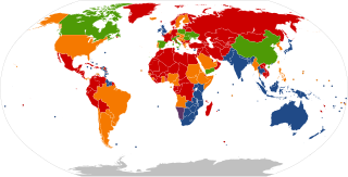
English (en): World map showing the
driving directions for all countries and any changes that have occurred in the past starting with Finland's change in 1858.
Has always driven on the right (RHT) or change happened before 1858. Originally drove on the left, but now drives on the right side of the road. Has always driven on the left side of the road (LHT). Originally drove on the right, but now drives on the left. Once had different rules of the road (depending on one's location), but now drives on the right.
Español:
español (es): Mapa mundi mostrando el
sentido de circulación de los países y las inversiones ocurridas.
Circulación por la derecha. Circulación originalmente por la izquierda, actualmente por la derecha. Circulación por la izquierda. Circulación originalmente por la derecha, actualmente por la izquierda. Circulación originalmente en sentidos diversos (dependiendo del lugar); actualmente por la derecha.
Fil:
fil (fil): Mapa sa mundo na nagpapakita
direksyon sa pagmamaneho sa kalsada sa lahat ng bansa at sa pagbabago na naganap noong nakaraan magmula pa sa pagbabago ng bansang Pinlandiya noong taong 1858.
Nagmamaneho sa kanan nagmula pa sa una. Sa kaliwa unang nagmamaneho, pero sa kasalukuyan ay sa kanan na nagmamaneho. Nagmamaneho sa kaliwa nagmula pa sa una. Sa kanan unang nagmamaneho, pero sa kasalukuyan ay sa kaliwa na nagmamaneho. May iba't ibang batas sa kalsada (depende sa kanilang lokasyon), pero sa kanan na nagmamaneho.
Français :
français (fr): Carte du monde montrant le
sens de circulation pour chaque pays et les changements passés depuis celui de la Finlande en 1858.
Conduite à droite. Originellement à gauche puis à droite. Conduite à gauche. Originellement à droite puis à gauche. Pays qui possédaient différentes règles de conduite (selon le lieu) et conduisant maintenant à droite.
Íslenska:
íslenska (is): Heimskort sem sýnir
umferðarhliðina fyrir öll lönd og nokkrar breytingar sem hafa gerst í fortíðinni síðan breytinguna Finnlands árið 1858.
Hefur alltaf notað hægri umferð. Upprunalega notaði vinstri umferð, en núna notar hægri umferð. Hefur alltaf notað vinstri umferð. Upprunalega notaði hægri umferð, en núna notar vinstri umferð. Einu sinni notaði annarskonar umferðarhliðar (fyrir annarskonar staði), en núna notar hægri umferð.
Italiano:
italiano (it): Mappa del mondo che mostra il
senso di marcia in ogni paese e i cambiamenti che sono avvenuti.
Ha sempre guidato a destra (RHT). Originariamente guidava a sinistra, attualmente guida a destra. Ha sempre guidato a sinistra (LHT). Originariamente guidava a destra, attualmente guida a sinistra. Aveva differenti regole di circolazione all'interno dei confini, ma ora guida a destra.
Polski:
polski (pl): Mapa świata pokazująca
kierunki ruchu drogowego dla wszystkich krajów i wszelkie zmiany, które zaszły w przeszłoci. Zaczynając od zmian w finlandii w roku 1858.
Zawsze obowiązywał ruch prawostronny. Pierwotnie
ruch lewostronny. Obecnie obowiązuje
ruch prawostronny. Zawsze obowiązywał ruch lewostronny. Pierwotnie ruch prawostronny. Obecnie obowiązuje ruch lewostronny. Kiedyś obowiązywały różne zasady poruszania się na drodze(zależnie od miejsca). Teraz jeździ się po prawej stronie.
Português:
português (pt): Mapa do mundo mostrando o
sentido de circulação dos países do mundo e as inversões já ocorridas.
Circulação pela direita. Circulava anteriormente pela esquerda, atualmente pela direita. Circulação pela esquerda. Circulava anteriormente pela direita, atualmente pela esquerda. Circulava em sentido oposto dependendo da localização.
Tiếng Việt:
Tiếng Việt (vi): Bản đồ thế giới hiển thị
hướng lưu thông của mọi quốc gia và mọi thay đổi đã xảy ra, bắt đầu với sự chuyển đổi của Phần Lan năm 1858.
luôn lưu thông bên phải từ trước đến nay. từng lưu thông bên trái, hiện đang lưu thông bên phải. luôn lưu thông bên trái từ trước đến nay. từng lưu thông bên phải, hiện đang lưu thông bên trái. một vài vùng lãnh thổ trực thuộc lưu thông bên trái, nhưng hiện đang lưu thông bên phải.
Türkçe:
Türkçe (tr): tüm ülkelerde ve 1858 yılında Finlandiya'nın değişikliği ile başlayan, geçmişte meydana gelen herhangi bir değişiklik tariflerini gösteren Dünya haritası.
Trafik, ilk baştan beri sağdan akmakta. Trafik başlangıçta soldan, ama şimdi sağdan akmakta. Trafik, ilk baştan beri soldan akmakta. Trafik başlangıçta sağdan, ama şimdi soldan akmakta. Önceleri farklı kurallara (bölgelere göre) sahip olup ama şimdi sağdan akan trafik.
Ελληνικά:
Ελληνικά (el): Παγκόσμιος χάρτης που δείχνει την
κατεύθυνση της κυκλοφορίας για όλες τις χώρες και τις αλλαγές που έχουν συμβεί, ξεκινώντας με αυτή της Φινλανδίας το 1858.
Ανέκαθεν οδήγηση στη δεξιά μερία του δρόμου. Αρχικά οδήγηση στα αριστερά, τώρα στα δεξιά. Ανέκαθεν οδήγηση στην αριστερή μερία του δρόμου. Αρχικά οδήγηση στα δεξιά, τώρα στα αριστερά. Είχε διάφορους κανόνες οδικής κυκλοφορίας (ανάλογα με την τοποθεσία), τώρα οδήγηση μόνο στα δεξιά.
Русский:
русский (ru): Карта мира, показывающая
направления движения по всем странам, с учётом любых изменений, которые произошли в прошлом (включая изменение в Финляндии в 1858 году).
Всегда было правосторонее движение. Первоначально было левостороннее движение, сейчас — правосторонее движение. Всегда было левосторонее движение. Первоначальное было правосторонее движение, сейчас — левосторонее движение. Существовали различные правила движения (в зависимости от места положения), но сейчас — правосторонее движение.
हिन्दी :
हिन्दी (hi): विश्व मानचित्र जहाँ सभी देशों के
यातायात की दिशा को 1858 में फ़िनलैंड द्वारा बदलाव के बाद से दर्शाया गया है।
हमेशा से दाएँ हाथ का। पहले बाए हाथ का, अभी दाएँ हाथ का। हमेशा से बाएँ हाथ का। पहले बाएँ हाथ का, अभी दाएँ हाथ का। पहले स्थान के अनुसार नियम अलग थे, अभी दाएँ हाथ का।
ไทย:
ไทย (th): แผนที่แสดงการขับรถชิดฝั่งของแต่ละประเทศ
ชิดขวา แต่ก่อนชิดซ้าย ปัจจุบันเปลี่ยนเป็นชิดขวา ชิดซ้าย แต่ก่อนชิดขวา ปัจจุบันเปลี่ยนเป็นชิดซ้าย แต่ก่อนมีความแตกต่างกันในแต่ละพื้นที่ของประเทศนั้น แต่ปัจจุบันเปลี่ยนเป็นชิดขวาเหมือนกันหมดแล้ว
日本語:
日本語 (ja): 通行区分を示す世界地図。
右側通行。 かつては左側通行だったが、現在は右側通行。 左側通行。 かつては右側通行だったが、現在は左側通行。 かつては地域によって通行区分が異なっていたが、現在は右側通行に統一。
中文: עברית :
עברית (he): מפת העולם המציגה את
כיווני התנועה בכל המדינות, ואת השינויים שחלו בכיוונים אלו, מאז השינוי בפינלנד בשנת 1858.
כיוון התנועה - בימין הכביש. בעבר, כיוון התנועה היה בשמאל הכביש, אך כיום - בימין הכביש. כיוון התנועה - בשמאל הכביש. בעבר, כיוון התנועה היה בימין הכביש, אך כיום - בשמאל הכביש. בעבר, כיוון התנועה לא היה קבוע והשתנה לפי מיקום הכביש במדינה, אך כיום, כיוון התנועה הוא בימין הכביש.
العربية :
العربية (ar): خريطة عالمية تظهر
ar:جهة القيادة لجميع البلدان والتغييرات التي حدثت بدءا من تغير فلندا عام 1985 م.
بلدان تستعمل اليمين كوجهة قيادة(RHT). بلدان في الأصل تستعمل اليسار كوجهة قيادة ، لكن الأن تستعمل اليمين. بلدان تستعمل اليسار كوجهة قيادة(LHT). بلدان في الأصل تستعمل اليمين كوجهة قيادة ، لكن الأن تستعمل اليسار. كانت تختلف في الأنظمة بين اليمين واليسار (إعتمادا على الموقع)لكن الأن تستخدم اليمين فقط.
فارسی :
فارسی (fa):
fa:جهت رانندگی در کشورهای مختلف برای همه کشورها و هر تغییری در جهت رانندگی که از هنگام ورود خودرو در آنها ایجاد شده است. آغاز تاریخ تغییراتِ نشان داده شده در این نقشه، تغییر جهت رانندگی در فنلاند در سال 1858 است.
از آغاز تاکنون، رانندگی در سمت راست بوده است. (RHT) در آغاز، رانندگی در سمت چپ راه بوده ولی امروزه در سمت راست راه رانندگی میشود. از آغاز تاکنون، رانندگی در سمت چپ بوده است. (LHT) در آغاز، رانندگی در سمت راست راه بوده ولی امروزه در سمت چپ راه رانندگی میشود. زمانی بسته به تقسیمات کشوری یا مکان خاص، قوانین متفاوتی برای رانندگی داشتند. اما امروزه در سمت راست راه رانندگی میشود.
|
| Date | |
| Source |
File:BlankMap-World-Microstates.svg This W3C-unspecified
vector image was created with
Inkscape . |
| Author | NuclearVacuum |
| Other versions |
File:Driving standards historic.png File:Countries driving on the left or right.svg |
Licensing
I, the copyright holder of this work, hereby publish it under the following licenses:
This file is licensed under the
Creative Commons
Attribution-Share Alike 3.0 Unported license.
- You are free:
- to share – to copy, distribute and transmit the work
- to remix – to adapt the work
- Under the following conditions:
- attribution – You must give appropriate credit, provide a link to the license, and indicate if changes were made. You may do so in any reasonable manner, but not in any way that suggests the licensor endorses you or your use.
- share alike – If you remix, transform, or build upon the material, you must distribute your contributions under the same or compatible license as the original.

|
Permission is granted to copy, distribute and/or modify this document under the terms of the GNU Free Documentation License, Version 1.2 or any later version published by the Free Software Foundation; with no Invariant Sections, no Front-Cover Texts, and no Back-Cover Texts. A copy of the license is included in the section entitled GNU Free Documentation License. |
You may select the license of your choice.
| Annotations | This image is annotated: View the annotations at Commons |
File history
Click on a date/time to view the file as it appeared at that time.
| Date/Time | Thumbnail | Dimensions | User | Comment | |
|---|---|---|---|---|---|
| current | 14:01, 20 December 2023 |
| 2,754 × 1,398 (1.2 MB) | Santiago Claudio | Corrected more map colors |
| 19:43, 2 August 2021 |
 | 2,754 × 1,398 (1.19 MB) | ThebeOkonma | Corrected map errors | |
| 14:07, 29 July 2021 |
 | 2,754 × 1,398 (1.2 MB) | Chubit | 更新圖像 | |
| 21:52, 28 April 2020 |
 | 940 × 477 (1.63 MB) | Numberguy6 | Brazil | |
| 11:27, 12 August 2011 |
 | 940 × 477 (1.63 MB) | Banhtrung1 | Added the South Sudan. | |
| 11:26, 12 August 2011 |
 | 940 × 477 (1.63 MB) | Banhtrung1 | Added the South Sudan. | |
| 17:26, 8 September 2009 |
 | 940 × 477 (1.62 MB) | NuclearVacuum | minor change in color | |
| 09:55, 8 September 2009 |
 | 940 × 477 (1.63 MB) | Haku8645 | Changed Samoa; also corrected Portugal and Gibraltar from red to orange | |
| 04:43, 27 June 2009 |
 | 940 × 477 (1.62 MB) | NuclearVacuum | made standard with the original file | |
| 01:24, 19 June 2009 |
 | 940 × 477 (1.75 MB) | NuclearVacuum | minor |
File usage
The following pages on the English Wikipedia use this file (pages on other projects are not listed):
Global file usage
The following other wikis use this file:
- Usage on af.wikipedia.org
- Usage on az.wikipedia.org
- Usage on bg.wikipedia.org
- Usage on de.wikipedia.org
- Usage on es.wikipedia.org
- Usage on fa.wikipedia.org
- Usage on fi.wikipedia.org
- Usage on fr.wikipedia.org
- Usage on fy.wikipedia.org
- Usage on id.wikipedia.org
- Usage on it.wikipedia.org
- Usage on lmo.wikipedia.org
- Usage on nl.wikipedia.org
- Usage on pt.wikipedia.org
- Usage on ru.wikipedia.org
- Usage on sd.wikipedia.org
- Usage on th.wikipedia.org
- Usage on uk.wikipedia.org
- Usage on vi.wikipedia.org
- Usage on zh.wikipedia.org
Metadata
Size of this PNG preview of this SVG file:
800 × 406 pixels. Other resolutions:
320 × 162 pixels |
640 × 325 pixels |
1,024 × 520 pixels |
1,280 × 650 pixels |
2,560 × 1,300 pixels |
2,754 × 1,398 pixels.
Original file (SVG file, nominally 2,754 × 1,398 pixels, file size: 1.2 MB)
| This is a file from the
Wikimedia Commons. Information from its
description page there is shown below. Commons is a freely licensed media file repository. You can help. |
Summary
| Description |
Bahasa Indonesia:
Bahasa Indonesia (id): Peta dunia yang menunjukkan arah mengemudi untuk semua negara serta setiap perubahan yang terjadi di masa lalu dimulai dengan perubahan di Finlandia pada tahun 1858.
Selalu melaju di sebelah kanan. Awalnya melaju di sebelah kiri, tapi sekarang melaju di sebelah kanan. Selalu melaju di sebelah kiri. Awalnya melaju di sebelah kanan, tapi sekarang melaju di sebelah kiri. Dahulu memiliki aturan jalan yang berbeda (tergantung pada lokasinya), tapi sekarang melaju di sebelah kanan.
Deutsch:
Deutsch (de): Weltkarte aller Länder mit Rechts- bzw.
Linksverkehr und historischen Umstellungen, die seit der Umstellung Finnland 1858 stattfanden
Rechtsverkehr. Ursprünglich Linksverkehr, jetzt aber Rechtsverkehr. Linksverkehr. Ursprünglich Rechtsverkehr, jetzt aber Linksverkehr. Einst mit unterschiedlichen Regelungen (abhängig vom Ort), jetzt mit Rechtsverkehr.
English:
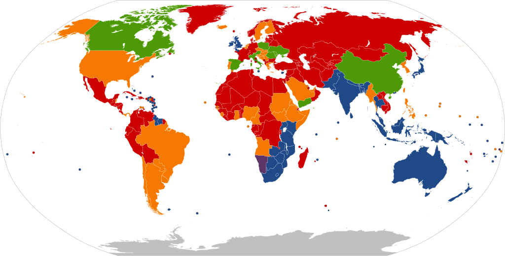
English (en): World map showing the
driving directions for all countries and any changes that have occurred in the past starting with Finland's change in 1858.
Has always driven on the right (RHT) or change happened before 1858. Originally drove on the left, but now drives on the right side of the road. Has always driven on the left side of the road (LHT). Originally drove on the right, but now drives on the left. Once had different rules of the road (depending on one's location), but now drives on the right.
Español:
español (es): Mapa mundi mostrando el
sentido de circulación de los países y las inversiones ocurridas.
Circulación por la derecha. Circulación originalmente por la izquierda, actualmente por la derecha. Circulación por la izquierda. Circulación originalmente por la derecha, actualmente por la izquierda. Circulación originalmente en sentidos diversos (dependiendo del lugar); actualmente por la derecha.
Fil:
fil (fil): Mapa sa mundo na nagpapakita
direksyon sa pagmamaneho sa kalsada sa lahat ng bansa at sa pagbabago na naganap noong nakaraan magmula pa sa pagbabago ng bansang Pinlandiya noong taong 1858.
Nagmamaneho sa kanan nagmula pa sa una. Sa kaliwa unang nagmamaneho, pero sa kasalukuyan ay sa kanan na nagmamaneho. Nagmamaneho sa kaliwa nagmula pa sa una. Sa kanan unang nagmamaneho, pero sa kasalukuyan ay sa kaliwa na nagmamaneho. May iba't ibang batas sa kalsada (depende sa kanilang lokasyon), pero sa kanan na nagmamaneho.
Français :
français (fr): Carte du monde montrant le
sens de circulation pour chaque pays et les changements passés depuis celui de la Finlande en 1858.
Conduite à droite. Originellement à gauche puis à droite. Conduite à gauche. Originellement à droite puis à gauche. Pays qui possédaient différentes règles de conduite (selon le lieu) et conduisant maintenant à droite.
Íslenska:
íslenska (is): Heimskort sem sýnir
umferðarhliðina fyrir öll lönd og nokkrar breytingar sem hafa gerst í fortíðinni síðan breytinguna Finnlands árið 1858.
Hefur alltaf notað hægri umferð. Upprunalega notaði vinstri umferð, en núna notar hægri umferð. Hefur alltaf notað vinstri umferð. Upprunalega notaði hægri umferð, en núna notar vinstri umferð. Einu sinni notaði annarskonar umferðarhliðar (fyrir annarskonar staði), en núna notar hægri umferð.
Italiano:
italiano (it): Mappa del mondo che mostra il
senso di marcia in ogni paese e i cambiamenti che sono avvenuti.
Ha sempre guidato a destra (RHT). Originariamente guidava a sinistra, attualmente guida a destra. Ha sempre guidato a sinistra (LHT). Originariamente guidava a destra, attualmente guida a sinistra. Aveva differenti regole di circolazione all'interno dei confini, ma ora guida a destra.
Polski:
polski (pl): Mapa świata pokazująca
kierunki ruchu drogowego dla wszystkich krajów i wszelkie zmiany, które zaszły w przeszłoci. Zaczynając od zmian w finlandii w roku 1858.
Zawsze obowiązywał ruch prawostronny. Pierwotnie
ruch lewostronny. Obecnie obowiązuje
ruch prawostronny. Zawsze obowiązywał ruch lewostronny. Pierwotnie ruch prawostronny. Obecnie obowiązuje ruch lewostronny. Kiedyś obowiązywały różne zasady poruszania się na drodze(zależnie od miejsca). Teraz jeździ się po prawej stronie.
Português:
português (pt): Mapa do mundo mostrando o
sentido de circulação dos países do mundo e as inversões já ocorridas.
Circulação pela direita. Circulava anteriormente pela esquerda, atualmente pela direita. Circulação pela esquerda. Circulava anteriormente pela direita, atualmente pela esquerda. Circulava em sentido oposto dependendo da localização.
Tiếng Việt:
Tiếng Việt (vi): Bản đồ thế giới hiển thị
hướng lưu thông của mọi quốc gia và mọi thay đổi đã xảy ra, bắt đầu với sự chuyển đổi của Phần Lan năm 1858.
luôn lưu thông bên phải từ trước đến nay. từng lưu thông bên trái, hiện đang lưu thông bên phải. luôn lưu thông bên trái từ trước đến nay. từng lưu thông bên phải, hiện đang lưu thông bên trái. một vài vùng lãnh thổ trực thuộc lưu thông bên trái, nhưng hiện đang lưu thông bên phải.
Türkçe:
Türkçe (tr): tüm ülkelerde ve 1858 yılında Finlandiya'nın değişikliği ile başlayan, geçmişte meydana gelen herhangi bir değişiklik tariflerini gösteren Dünya haritası.
Trafik, ilk baştan beri sağdan akmakta. Trafik başlangıçta soldan, ama şimdi sağdan akmakta. Trafik, ilk baştan beri soldan akmakta. Trafik başlangıçta sağdan, ama şimdi soldan akmakta. Önceleri farklı kurallara (bölgelere göre) sahip olup ama şimdi sağdan akan trafik.
Ελληνικά:
Ελληνικά (el): Παγκόσμιος χάρτης που δείχνει την
κατεύθυνση της κυκλοφορίας για όλες τις χώρες και τις αλλαγές που έχουν συμβεί, ξεκινώντας με αυτή της Φινλανδίας το 1858.
Ανέκαθεν οδήγηση στη δεξιά μερία του δρόμου. Αρχικά οδήγηση στα αριστερά, τώρα στα δεξιά. Ανέκαθεν οδήγηση στην αριστερή μερία του δρόμου. Αρχικά οδήγηση στα δεξιά, τώρα στα αριστερά. Είχε διάφορους κανόνες οδικής κυκλοφορίας (ανάλογα με την τοποθεσία), τώρα οδήγηση μόνο στα δεξιά.
Русский:
русский (ru): Карта мира, показывающая
направления движения по всем странам, с учётом любых изменений, которые произошли в прошлом (включая изменение в Финляндии в 1858 году).
Всегда было правосторонее движение. Первоначально было левостороннее движение, сейчас — правосторонее движение. Всегда было левосторонее движение. Первоначальное было правосторонее движение, сейчас — левосторонее движение. Существовали различные правила движения (в зависимости от места положения), но сейчас — правосторонее движение.
हिन्दी :
हिन्दी (hi): विश्व मानचित्र जहाँ सभी देशों के
यातायात की दिशा को 1858 में फ़िनलैंड द्वारा बदलाव के बाद से दर्शाया गया है।
हमेशा से दाएँ हाथ का। पहले बाए हाथ का, अभी दाएँ हाथ का। हमेशा से बाएँ हाथ का। पहले बाएँ हाथ का, अभी दाएँ हाथ का। पहले स्थान के अनुसार नियम अलग थे, अभी दाएँ हाथ का।
ไทย:
ไทย (th): แผนที่แสดงการขับรถชิดฝั่งของแต่ละประเทศ
ชิดขวา แต่ก่อนชิดซ้าย ปัจจุบันเปลี่ยนเป็นชิดขวา ชิดซ้าย แต่ก่อนชิดขวา ปัจจุบันเปลี่ยนเป็นชิดซ้าย แต่ก่อนมีความแตกต่างกันในแต่ละพื้นที่ของประเทศนั้น แต่ปัจจุบันเปลี่ยนเป็นชิดขวาเหมือนกันหมดแล้ว
日本語:
日本語 (ja): 通行区分を示す世界地図。
右側通行。 かつては左側通行だったが、現在は右側通行。 左側通行。 かつては右側通行だったが、現在は左側通行。 かつては地域によって通行区分が異なっていたが、現在は右側通行に統一。
中文: עברית :
עברית (he): מפת העולם המציגה את
כיווני התנועה בכל המדינות, ואת השינויים שחלו בכיוונים אלו, מאז השינוי בפינלנד בשנת 1858.
כיוון התנועה - בימין הכביש. בעבר, כיוון התנועה היה בשמאל הכביש, אך כיום - בימין הכביש. כיוון התנועה - בשמאל הכביש. בעבר, כיוון התנועה היה בימין הכביש, אך כיום - בשמאל הכביש. בעבר, כיוון התנועה לא היה קבוע והשתנה לפי מיקום הכביש במדינה, אך כיום, כיוון התנועה הוא בימין הכביש.
العربية :
العربية (ar): خريطة عالمية تظهر
ar:جهة القيادة لجميع البلدان والتغييرات التي حدثت بدءا من تغير فلندا عام 1985 م.
بلدان تستعمل اليمين كوجهة قيادة(RHT). بلدان في الأصل تستعمل اليسار كوجهة قيادة ، لكن الأن تستعمل اليمين. بلدان تستعمل اليسار كوجهة قيادة(LHT). بلدان في الأصل تستعمل اليمين كوجهة قيادة ، لكن الأن تستعمل اليسار. كانت تختلف في الأنظمة بين اليمين واليسار (إعتمادا على الموقع)لكن الأن تستخدم اليمين فقط.
فارسی :
فارسی (fa):
fa:جهت رانندگی در کشورهای مختلف برای همه کشورها و هر تغییری در جهت رانندگی که از هنگام ورود خودرو در آنها ایجاد شده است. آغاز تاریخ تغییراتِ نشان داده شده در این نقشه، تغییر جهت رانندگی در فنلاند در سال 1858 است.
از آغاز تاکنون، رانندگی در سمت راست بوده است. (RHT) در آغاز، رانندگی در سمت چپ راه بوده ولی امروزه در سمت راست راه رانندگی میشود. از آغاز تاکنون، رانندگی در سمت چپ بوده است. (LHT) در آغاز، رانندگی در سمت راست راه بوده ولی امروزه در سمت چپ راه رانندگی میشود. زمانی بسته به تقسیمات کشوری یا مکان خاص، قوانین متفاوتی برای رانندگی داشتند. اما امروزه در سمت راست راه رانندگی میشود.
|
| Date | |
| Source |
File:BlankMap-World-Microstates.svg This W3C-unspecified
vector image was created with
Inkscape . |
| Author | NuclearVacuum |
| Other versions |
File:Driving standards historic.png File:Countries driving on the left or right.svg |
Licensing
I, the copyright holder of this work, hereby publish it under the following licenses:
This file is licensed under the
Creative Commons
Attribution-Share Alike 3.0 Unported license.
- You are free:
- to share – to copy, distribute and transmit the work
- to remix – to adapt the work
- Under the following conditions:
- attribution – You must give appropriate credit, provide a link to the license, and indicate if changes were made. You may do so in any reasonable manner, but not in any way that suggests the licensor endorses you or your use.
- share alike – If you remix, transform, or build upon the material, you must distribute your contributions under the same or compatible license as the original.
|
|
Permission is granted to copy, distribute and/or modify this document under the terms of the GNU Free Documentation License, Version 1.2 or any later version published by the Free Software Foundation; with no Invariant Sections, no Front-Cover Texts, and no Back-Cover Texts. A copy of the license is included in the section entitled GNU Free Documentation License. |
You may select the license of your choice.
| Annotations | This image is annotated: View the annotations at Commons |
File history
Click on a date/time to view the file as it appeared at that time.
| Date/Time | Thumbnail | Dimensions | User | Comment | |
|---|---|---|---|---|---|
| current | 14:01, 20 December 2023 |
| 2,754 × 1,398 (1.2 MB) | Santiago Claudio | Corrected more map colors |
| 19:43, 2 August 2021 |
| 2,754 × 1,398 (1.19 MB) | ThebeOkonma | Corrected map errors | |
| 14:07, 29 July 2021 |
| 2,754 × 1,398 (1.2 MB) | Chubit | 更新圖像 | |
| 21:52, 28 April 2020 |
| 940 × 477 (1.63 MB) | Numberguy6 | Brazil | |
| 11:27, 12 August 2011 |
| 940 × 477 (1.63 MB) | Banhtrung1 | Added the South Sudan. | |
| 11:26, 12 August 2011 |
| 940 × 477 (1.63 MB) | Banhtrung1 | Added the South Sudan. | |
| 17:26, 8 September 2009 |
| 940 × 477 (1.62 MB) | NuclearVacuum | minor change in color | |
| 09:55, 8 September 2009 |
| 940 × 477 (1.63 MB) | Haku8645 | Changed Samoa; also corrected Portugal and Gibraltar from red to orange | |
| 04:43, 27 June 2009 |
| 940 × 477 (1.62 MB) | NuclearVacuum | made standard with the original file | |
| 01:24, 19 June 2009 |
| 940 × 477 (1.75 MB) | NuclearVacuum | minor |
File usage
The following pages on the English Wikipedia use this file (pages on other projects are not listed):
Global file usage
The following other wikis use this file:
- Usage on af.wikipedia.org
- Usage on az.wikipedia.org
- Usage on bg.wikipedia.org
- Usage on de.wikipedia.org
- Usage on es.wikipedia.org
- Usage on fa.wikipedia.org
- Usage on fi.wikipedia.org
- Usage on fr.wikipedia.org
- Usage on fy.wikipedia.org
- Usage on id.wikipedia.org
- Usage on it.wikipedia.org
- Usage on lmo.wikipedia.org
- Usage on nl.wikipedia.org
- Usage on pt.wikipedia.org
- Usage on ru.wikipedia.org
- Usage on sd.wikipedia.org
- Usage on th.wikipedia.org
- Usage on uk.wikipedia.org
- Usage on vi.wikipedia.org
- Usage on zh.wikipedia.org