No higher resolution available.
Congo_regions_named.png (300 × 337 pixels, file size: 14 KB, MIME type: image/png)
| This is a file from the
Wikimedia Commons. Information from its
description page there is shown below. Commons is a freely licensed media file repository. You can help. |
| Description |
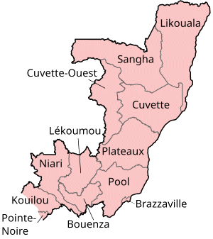
Map of the regions of the Republic of the Congo, named in French (local language), mostly compatible with English. The individual maps are: |
| Date | |
| Source | Self-made, traced from public domain UN or CIA maps. |
| Author | User:Golbez |
| Permission ( Reusing this file) |
Provide attribution, please. See below. |
I, the copyright holder of this work, hereby publish it under the following licenses:
This file is licensed under the
Creative Commons Attribution-Share Alike
2.5 Generic,
2.0 Generic and
1.0 Generic license.
- You are free:
- to share – to copy, distribute and transmit the work
- to remix – to adapt the work
- Under the following conditions:
- attribution – You must give appropriate credit, provide a link to the license, and indicate if changes were made. You may do so in any reasonable manner, but not in any way that suggests the licensor endorses you or your use.
- share alike – If you remix, transform, or build upon the material, you must distribute your contributions under the same or compatible license as the original.

|
Permission is granted to copy, distribute and/or modify this document under the terms of the GNU Free Documentation License, Version 1.2 or any later version published by the Free Software Foundation; with no Invariant Sections, no Front-Cover Texts, and no Back-Cover Texts. A copy of the license is included in the section entitled GNU Free Documentation License. |
| This file is licensed under the Creative Commons Attribution-Share Alike 3.0 Unported license. | ||
| ||
| This licensing tag was added to this file as part of the GFDL licensing update. |
You may select the license of your choice.
File history
Click on a date/time to view the file as it appeared at that time.
| Date/Time | Thumbnail | Dimensions | User | Comment | |
|---|---|---|---|---|---|
| current | 17:29, 1 October 2023 |
| 300 × 337 (14 KB) | Yunan973 | fix all boundaries according to last offical maps (2023) |
| 16:53, 28 December 2004 |
 | 300 × 370 (13 KB) | Golbez | Map of the regions of the Republic of the Congo. Made by User:Golbez. {{cc-by-sa-2.0}} |
File usage
The following pages on the English Wikipedia use this file (pages on other projects are not listed):
- Abala District
- Allembé District
- Bambama District
- Banda District (Republic of the Congo)
- Boko-Songho District
- Boko District
- Bouanéla District
- Boundji District
- Bétou District
- Departments of the Republic of the Congo
- Districts of the Republic of the Congo
- Divénié District
- Djambala District
- Dongou District
- Enyellé District
- Epena District
- Etoumbi District
- Ewo District
- Gamboma District
- Goma Tsé-Tsé District
- Hinda District
- Ignié District
- Ile Mbamou
- Impfondo District
- Kabo District
- Kakamoeka District
- Kayes District
- Kelle District
- Kibangou District
- Kimba District
- Kimongo District
- Kindamba District
- Kingoué District
- Kinkala District
- Komono District
- Liranga District
- Londéla–Kayes District
- Loudima District
- Louingui District
- Loukela District
- Loukoléla District
- Loumo District
- Louvakou District
- Lékana District
- Mabombo District
- Madingo-Kayes District
- Madingou District
- Makabana District
- Makotimpoko District
- Makoua District
- Mayama District
- Mayoko District
- Mayéyé District
- Mbama District (Republic of the Congo)
- Mbanza–Ndounga District
- Mbinda District
- Mbomo District
- Mbon District
- Mfouati District
- Mindouli District
- Mokéko District
- Mossaka District
- Moungoundou-nord District
- Moungoundou-sud District
- Moutamba District
- Mouyondzi District
- Mpouya District
- Mvouti District
- N'gbala District
- Ngabé District
- Ngo District
- Ngoko District
- Ntokou District
- Nyanga District (Republic of the Congo)
- Nzambi District
- Okoyo District
- Ollombo District
- Ongogni District
- Ouésso District
- Oyo District
- Pikounda District
- Pointe-Noire
- Republic of the Congo
- Sembé District
- Sibiti District
- Souanké District
- Tchiamba-Nzassi
- Tchikapika District
- Tsiaki District
- Vindza District
- Yamba District (Republic of the Congo)
- Yaya District (Republic of the Congo)
- Zanaga District
- User:Jonny-mt/Gallery of current first-level administrative country subdivisions maps
- User talk:Markussep/Archive 4
- Template:Departments of the Republic of the Congo Image Map
- Template:Districts of the Republic of the Congo
- Portal:Republic of the Congo
Global file usage
The following other wikis use this file:
- Usage on ast.wikipedia.org
- Usage on avk.wikipedia.org
- Usage on be-tarask.wikipedia.org
- Usage on bg.wikipedia.org
- Usage on bn.wikipedia.org
- Usage on br.wikipedia.org
- Usage on ca.wikipedia.org
- Usage on de.wikipedia.org
- Usage on el.wikipedia.org
- Usage on es.wikipedia.org
- Usage on eu.wikipedia.org
- Usage on fa.wikipedia.org
- Usage on fi.wikipedia.org
- Usage on frr.wikipedia.org
- Usage on fr.wikipedia.org
- Usage on he.wikipedia.org
- Usage on hr.wikipedia.org
- Usage on hu.wikipedia.org
- Usage on id.wikipedia.org
- Usage on is.wikipedia.org
- Usage on it.wikipedia.org
- Usage on ja.wikipedia.org
- Usage on ka.wikipedia.org
- Usage on kg.wikipedia.org
- Usage on kk.wikipedia.org
- Usage on ko.wikipedia.org
- Usage on li.wikipedia.org
- Usage on ln.wikipedia.org
- Usage on lt.wikipedia.org
- Usage on mt.wikipedia.org
- Usage on mzn.wikipedia.org
- Usage on nl.wikipedia.org
- Usage on nn.wikipedia.org
- Usage on no.wikipedia.org
View more global usage of this file.
Metadata
No higher resolution available.
Congo_regions_named.png (300 × 337 pixels, file size: 14 KB, MIME type: image/png)
| This is a file from the
Wikimedia Commons. Information from its
description page there is shown below. Commons is a freely licensed media file repository. You can help. |
| Description |
Map of the regions of the Republic of the Congo, named in French (local language), mostly compatible with English. The individual maps are: |
| Date | |
| Source | Self-made, traced from public domain UN or CIA maps. |
| Author | User:Golbez |
| Permission ( Reusing this file) |
Provide attribution, please. See below. |
I, the copyright holder of this work, hereby publish it under the following licenses:
This file is licensed under the
Creative Commons Attribution-Share Alike
2.5 Generic,
2.0 Generic and
1.0 Generic license.
- You are free:
- to share – to copy, distribute and transmit the work
- to remix – to adapt the work
- Under the following conditions:
- attribution – You must give appropriate credit, provide a link to the license, and indicate if changes were made. You may do so in any reasonable manner, but not in any way that suggests the licensor endorses you or your use.
- share alike – If you remix, transform, or build upon the material, you must distribute your contributions under the same or compatible license as the original.
|
|
Permission is granted to copy, distribute and/or modify this document under the terms of the GNU Free Documentation License, Version 1.2 or any later version published by the Free Software Foundation; with no Invariant Sections, no Front-Cover Texts, and no Back-Cover Texts. A copy of the license is included in the section entitled GNU Free Documentation License. |
| This file is licensed under the Creative Commons Attribution-Share Alike 3.0 Unported license. | ||
| ||
| This licensing tag was added to this file as part of the GFDL licensing update. |
You may select the license of your choice.
File history
Click on a date/time to view the file as it appeared at that time.
| Date/Time | Thumbnail | Dimensions | User | Comment | |
|---|---|---|---|---|---|
| current | 17:29, 1 October 2023 |
| 300 × 337 (14 KB) | Yunan973 | fix all boundaries according to last offical maps (2023) |
| 16:53, 28 December 2004 |
| 300 × 370 (13 KB) | Golbez | Map of the regions of the Republic of the Congo. Made by User:Golbez. {{cc-by-sa-2.0}} |
File usage
The following pages on the English Wikipedia use this file (pages on other projects are not listed):
- Abala District
- Allembé District
- Bambama District
- Banda District (Republic of the Congo)
- Boko-Songho District
- Boko District
- Bouanéla District
- Boundji District
- Bétou District
- Departments of the Republic of the Congo
- Districts of the Republic of the Congo
- Divénié District
- Djambala District
- Dongou District
- Enyellé District
- Epena District
- Etoumbi District
- Ewo District
- Gamboma District
- Goma Tsé-Tsé District
- Hinda District
- Ignié District
- Ile Mbamou
- Impfondo District
- Kabo District
- Kakamoeka District
- Kayes District
- Kelle District
- Kibangou District
- Kimba District
- Kimongo District
- Kindamba District
- Kingoué District
- Kinkala District
- Komono District
- Liranga District
- Londéla–Kayes District
- Loudima District
- Louingui District
- Loukela District
- Loukoléla District
- Loumo District
- Louvakou District
- Lékana District
- Mabombo District
- Madingo-Kayes District
- Madingou District
- Makabana District
- Makotimpoko District
- Makoua District
- Mayama District
- Mayoko District
- Mayéyé District
- Mbama District (Republic of the Congo)
- Mbanza–Ndounga District
- Mbinda District
- Mbomo District
- Mbon District
- Mfouati District
- Mindouli District
- Mokéko District
- Mossaka District
- Moungoundou-nord District
- Moungoundou-sud District
- Moutamba District
- Mouyondzi District
- Mpouya District
- Mvouti District
- N'gbala District
- Ngabé District
- Ngo District
- Ngoko District
- Ntokou District
- Nyanga District (Republic of the Congo)
- Nzambi District
- Okoyo District
- Ollombo District
- Ongogni District
- Ouésso District
- Oyo District
- Pikounda District
- Pointe-Noire
- Republic of the Congo
- Sembé District
- Sibiti District
- Souanké District
- Tchiamba-Nzassi
- Tchikapika District
- Tsiaki District
- Vindza District
- Yamba District (Republic of the Congo)
- Yaya District (Republic of the Congo)
- Zanaga District
- User:Jonny-mt/Gallery of current first-level administrative country subdivisions maps
- User talk:Markussep/Archive 4
- Template:Departments of the Republic of the Congo Image Map
- Template:Districts of the Republic of the Congo
- Portal:Republic of the Congo
Global file usage
The following other wikis use this file:
- Usage on ast.wikipedia.org
- Usage on avk.wikipedia.org
- Usage on be-tarask.wikipedia.org
- Usage on bg.wikipedia.org
- Usage on bn.wikipedia.org
- Usage on br.wikipedia.org
- Usage on ca.wikipedia.org
- Usage on de.wikipedia.org
- Usage on el.wikipedia.org
- Usage on es.wikipedia.org
- Usage on eu.wikipedia.org
- Usage on fa.wikipedia.org
- Usage on fi.wikipedia.org
- Usage on frr.wikipedia.org
- Usage on fr.wikipedia.org
- Usage on he.wikipedia.org
- Usage on hr.wikipedia.org
- Usage on hu.wikipedia.org
- Usage on id.wikipedia.org
- Usage on is.wikipedia.org
- Usage on it.wikipedia.org
- Usage on ja.wikipedia.org
- Usage on ka.wikipedia.org
- Usage on kg.wikipedia.org
- Usage on kk.wikipedia.org
- Usage on ko.wikipedia.org
- Usage on li.wikipedia.org
- Usage on ln.wikipedia.org
- Usage on lt.wikipedia.org
- Usage on mt.wikipedia.org
- Usage on mzn.wikipedia.org
- Usage on nl.wikipedia.org
- Usage on nn.wikipedia.org
- Usage on no.wikipedia.org
View more global usage of this file.